You are here: Home > Network List > TA - USArray Transportable Network (new EarthScope stations) Stations List
> Station O01C Eel River Conservation Camp, Redway, CA, USA > Earthquake Result Viewer
O01C Eel River Conservation Camp, Redway, CA, USA - Earthquake Result Viewer
| Earthquake location: |
Kermadec Islands Region |
| Earthquake latitude/longitude: |
-31.8/-179.3 |
| Earthquake time(UTC): |
2006/05/16 (136) 10:39:23 GMT |
| Earthquake Depth: |
152 km |
| Earthquake Magnitude: |
6.8 MB, 7.4 MW, 7.4 MW |
| Earthquake Catalog/Contributor: |
WHDF/NEIC |
|
| Network: |
TA USArray Transportable Network (new EarthScope stations) |
| Station: |
O01C Eel River Conservation Camp, Redway, CA, USA |
| Lat/Lon: |
40.14 N/123.82 W |
| Elevation: |
138 m |
|
| Distance: |
88.1 deg |
| Az: |
39.204 deg |
| Baz: |
224.605 deg |
| Ray Param: |
0.04250585 |
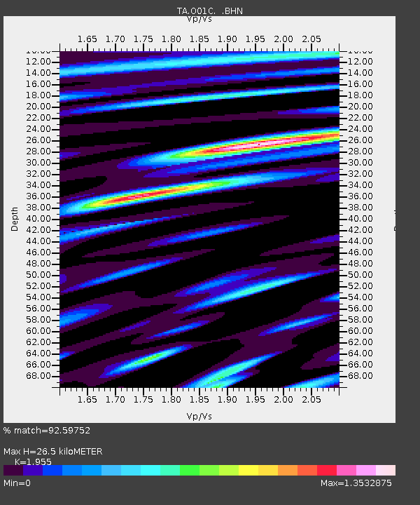
| Estimated Moho Depth: |
26.5 km |
| Estimated Crust Vp/Vs: |
1.96 |
| Assumed Crust Vp: |
6.566 km/s |
| Estimated Crust Vs: |
3.359 km/s |
| Estimated Crust Poisson's Ratio: |
0.32 |
|
| Radial Match: |
92.59752 % |
| Radial Bump: |
400 |
| Transverse Match: |
88.96454 % |
| Transverse Bump: |
400 |
| SOD ConfigId: |
2669 |
| Insert Time: |
2010-03-07 04:12:28.039 +0000 |
| GWidth: |
2.5 |
| Max Bumps: |
400 |
| Tol: |
0.001 |
|
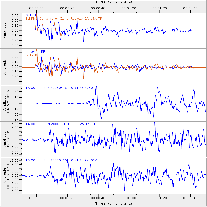
Signal To Noise
| Channel | StoN | STA | LTA |
| TA:O01C: :BHN:20060516T10:51:25.47501Z | 2.3659494 | 7.280266E-7 | 3.077101E-7 |
| TA:O01C: :BHE:20060516T10:51:25.47501Z | 0.94497496 | 4.1425415E-7 | 4.3837582E-7 |
| TA:O01C: :BHZ:20060516T10:51:25.47501Z | 4.352789 | 1.3341408E-6 | 3.0650253E-7 |
| Arrivals |
| Ps | 3.9 SECOND |
| PpPs | 12 SECOND |
| PsPs/PpSs | 16 SECOND |


