You are here: Home > Network List > TA - USArray Transportable Network (new EarthScope stations) Stations List
> Station R12A Pony Springs, Pioche, NV, USA > Earthquake Result Viewer
R12A Pony Springs, Pioche, NV, USA - Earthquake Result Viewer
| Earthquake location: |
Santa Cruz Islands |
| Earthquake latitude/longitude: |
-11.6/165.8 |
| Earthquake time(UTC): |
2007/09/02 (245) 01:05:18 GMT |
| Earthquake Depth: |
35 km |
| Earthquake Magnitude: |
5.9 MB, 7.3 MS, 7.2 MW, 6.9 ME |
| Earthquake Catalog/Contributor: |
WHDF/NEIC |
|
| Network: |
TA USArray Transportable Network (new EarthScope stations) |
| Station: |
R12A Pony Springs, Pioche, NV, USA |
| Lat/Lon: |
38.33 N/114.61 W |
| Elevation: |
1845 m |
|
| Distance: |
89.1 deg |
| Az: |
50.691 deg |
| Baz: |
254.561 deg |
| Ray Param: |
0.04203119 |
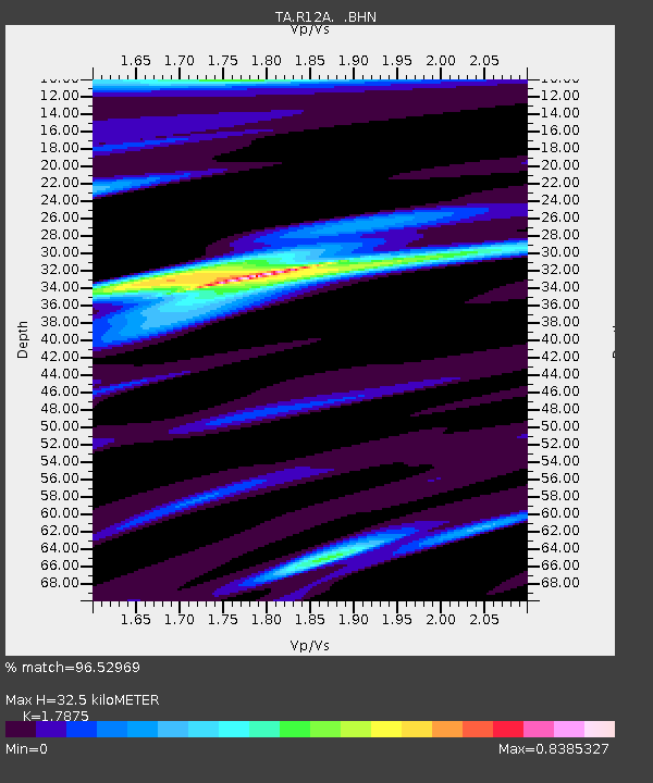
| Estimated Moho Depth: |
32.5 km |
| Estimated Crust Vp/Vs: |
1.79 |
| Assumed Crust Vp: |
6.276 km/s |
| Estimated Crust Vs: |
3.511 km/s |
| Estimated Crust Poisson's Ratio: |
0.27 |
|
| Radial Match: |
96.52969 % |
| Radial Bump: |
400 |
| Transverse Match: |
87.76641 % |
| Transverse Bump: |
400 |
| SOD ConfigId: |
2564 |
| Insert Time: |
2010-03-07 04:12:40.416 +0000 |
| GWidth: |
2.5 |
| Max Bumps: |
400 |
| Tol: |
0.001 |
|

Signal To Noise
| Channel | StoN | STA | LTA |
| TA:R12A: :BHN:20070902T01:17:38.725012Z | 3.408949 | 2.1766853E-7 | 6.385209E-8 |
| TA:R12A: :BHE:20070902T01:17:38.725012Z | 9.607632 | 7.695841E-7 | 8.010134E-8 |
| TA:R12A: :BHZ:20070902T01:17:38.725012Z | 22.87917 | 2.1545086E-6 | 9.4169E-8 |
| Arrivals |
| Ps | 4.2 SECOND |
| PpPs | 14 SECOND |
| PsPs/PpSs | 18 SECOND |


