
Station TA R12A - Pony Springs, Pioche, NV, USA
Network: TA - USArray Transportable Network (new EarthScope stations)
Nearby stations (2 deg radius)

| Station | Name | (Lat, Lon) | Start / End | Elevation |
| R12A | Pony Springs, Pioche, NV, USA | (38.33, -114.61) | 2007-01-25 / 2499-01-01 | 1.8 km |
| Crust2 Type: | M5,extended crust, 0.5 km seds. |
| Thickness Estimate: | 33 km |
| Thickness StdDev: | 0.3 km |
| Vp/Vs Estimate: | 1.76 |
| Vp/Vs StdDev: | 0.02 |
| Vs Estimate: | 3.571 km/s |
| Poisson's Ratio: | 0.26 |
| Peak Value: | 0.05 |
| Assumed Vp: | 6.276 km/s |
| Ps Weight: | 0.33333334 |
| PpPs Weight: | 0.33333334 |
| PsPs Weight: | 0.33333328 |
| Residual Complexity: | 0.463 |
| Nearby stations H: | +- |
| (2.0 deg) Vp/Vs: | +- |
8 with match > 90% ( 42.105263 %) and 19 with match > 80% ( 100.0 %) out of 19.
Download stack as xyz text file.
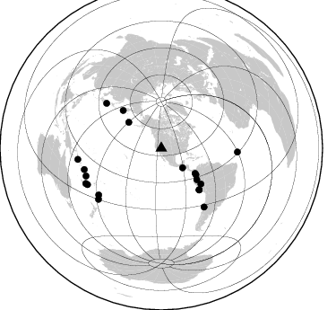
Azimuth Distribution of Events:
Prior Results for this Station
| Study | Thickness | Vp/Vs | Vp | Vs | Poissons Ratio | Extra |
| EARS | 33 km | 1.76 | 6.276 km/s | 3.571 km/s | 0.26 | |
| Crust2.0 | 31 km | 1.78 | 6.276 km/s | 3.529 km/s | 0.27 | M5,extended crust, 0.5 km seds. |
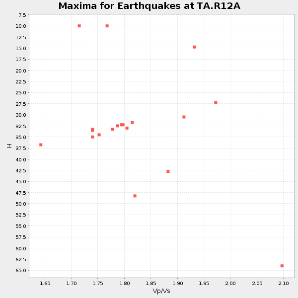
| Global Maxima | 33 km | 1.76 | 6.276 km/s | 3.571 km/s | 0.26 | amp=0.053952567 |
| Local Maxima 1 | 34 km | 1.76 | 6.276 km/s | 3.556 km/s | 0.26 | amp=0.025631769 |
| Local Maxima 2 | 26 km | 1.90 | 6.276 km/s | 3.303 km/s | 0.31 | amp=0.022196347 |
| Local Maxima 3 | 33 km | 1.66 | 6.276 km/s | 3.781 km/s | 0.22 | amp=0.017618624 |
| Local Maxima 4 | 36 km | 1.67 | 6.276 km/s | 3.758 km/s | 0.22 | amp=0.007970674 |
| Predicted Arrivals for vertical incidence (zero ray parameter) | |
| Ps | 3.95 SECOND |
| PpPs | 14.39 SECOND |
| PsPs/PpSs | 18.34 SECOND |
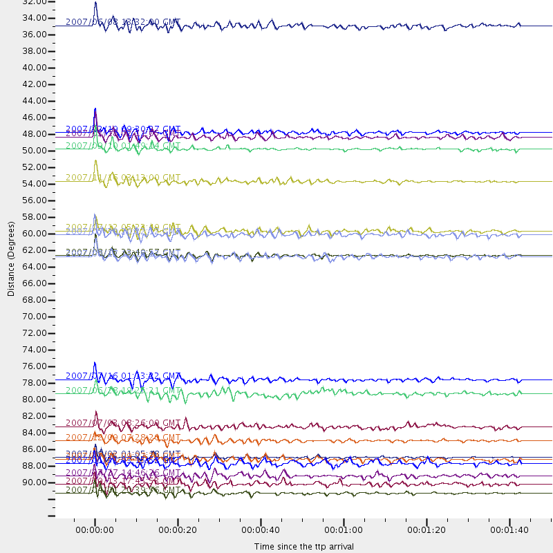
Events Processed for this Station
Download zip of receiver functions as SAC
Plot maxima for each earthquake.
Events Used in the Stack
(19 events)| Radial Match | Distance | Baz | FERegion | Time | Lat/Lon | Depth | Magnitude |
| 96.52969 | 89.1 deg | 254.561 deg | Santa Cruz Islands | 2007/09/02 01:05:18 GMT | (-11.6, 165.8) | 35 km | 5.9 MB, 7.3 MS, 7.2 MW, 6.9 ME |
| 96.332794 | 62.5 deg | 137.526 deg | Near Coast Of Peru | 2007/08/15 23:40:57 GMT | (-13.4, -76.6) | 39 km | 6.7 MB, 7.9 MS, 8.0 MW, 7.5 ME |
| 96.28494 | 93.9 deg | 262.365 deg | Solomon Islands | 2007/04/01 20:39:56 GMT | (-8.5, 157.0) | 10 km | 6.8 MB, 7.9 MS, 8.1 MW, 7.7 ME |
| 95.79009 | 48.5 deg | 127.314 deg | Near West Coast Of Colombia | 2007/09/10 01:49:14 GMT | (3.0, -78.0) | 31 km | 6.1 MB, 6.7 MS, 6.8 MW |
| 94.957695 | 52.8 deg | 131.321 deg | Peru-Ecuador Border Region | 2007/11/16 03:13:00 GMT | (-2.3, -77.8) | 123 km | 6.3 MB, 6.8 MW, 6.7 MW |
| 91.70069 | 78.9 deg | 309.202 deg | Near West Coast Of Honshu, Japan | 2007/07/16 01:13:22 GMT | (37.5, 138.4) | 12 km | 6.5 MB, 6.4 MS, 6.6 MW, 6.5 MW |
| 91.09308 | 62.7 deg | 137.657 deg | Near Coast Of Peru | 2007/08/17 13:18:13 GMT | (-13.6, -76.6) | 48 km | 5.6 MB, 5.6 MS, 5.9 MW |
| 90.13337 | 87.0 deg | 233.355 deg | South Of Fiji Islands | 2007/12/09 07:28:20 GMT | (-26.0, -177.5) | 152 km | 7.0 MB, 7.8 MW, 7.7 MW |
| 89.13512 | 47.0 deg | 126.518 deg | South Of Panama | 2007/03/18 02:11:05 GMT | (4.6, -78.5) | 8.0 km | 6.4 MB, 5.7 MS, 6.2 MW, 6.1 MW |
| 88.0078 | 89.4 deg | 249.913 deg | Vanuatu Islands | 2007/07/15 09:27:34 GMT | (-15.4, 168.6) | 8.0 km | 6.0 MB, 5.8 MS, 6.1 MW, 6.0 MW |
| 87.4568 | 46.4 deg | 308.309 deg | Andreanof Islands, Aleutian Is. | 2007/12/19 09:30:27 GMT | (51.4, -179.5) | 29 km | 6.4 MB, 7.1 MS, 7.1 MW, 7.0 MW |
| 85.12863 | 32.3 deg | 132.662 deg | Near Coast Of Guatemala | 2007/06/08 13:32:00 GMT | (13.8, -90.8) | 48 km | 5.5 MB, 5.4 MS, 5.8 MW, 5.8 MW |
| 82.91549 | 59.3 deg | 131.944 deg | Peru-Brazil Border Region | 2007/07/12 05:23:49 GMT | (-7.9, -74.4) | 152 km | 5.9 MB, 6.1 MW, 6.0 MW |
| 82.31769 | 59.8 deg | 314.565 deg | Kamchatka Peninsula, Russia | 2007/05/30 20:22:12 GMT | (52.1, 157.3) | 116 km | 6.4 MB, 6.4 MW, 6.4 MW |
| 81.851944 | 80.7 deg | 143.843 deg | Near Coast Of Central Chile | 2007/06/28 19:25:21 GMT | (-32.0, -71.3) | 69 km | 5.5 MB, 5.7 MW, 5.6 MW |
| 81.75018 | 89.9 deg | 231.018 deg | Kermadec Islands, New Zealand | 2007/01/31 03:15:52 GMT | (-29.8, -178.0) | 34 km | 6.1 MB, 6.3 MS, 6.5 MW, 6.4 MW |
| 81.65273 | 91.6 deg | 243.869 deg | Southeast Of Loyalty Islands | 2007/07/27 14:46:26 GMT | (-21.5, 170.9) | 10 km | 6.0 MB, 6.0 MS, 6.1 MW, 6.1 MW |
| 80.51446 | 92.7 deg | 245.097 deg | Southeast Of Loyalty Islands | 2007/10/13 17:45:53 GMT | (-21.2, 169.2) | 37 km | 5.8 MB, 5.9 MS, 6.1 MW, 6.1 MW |
| 80.472664 | 85.1 deg | 92.946 deg | Central Mid-Atlantic Ridge | 2007/07/03 08:26:00 GMT | (0.7, -30.3) | 10 km | 5.8 MB, 5.9 MS, 6.3 MW, 6.1 MW |
Losers
(0 events)| Radial Match | Distance | Baz | FERegion | Time | Lat/Lon | Depth | Magnitude | Reason |
