You are here: Home > Network List > TA - USArray Transportable Network (new EarthScope stations) Stations List
> Station R12A Pony Springs, Pioche, NV, USA > Earthquake Result Viewer
R12A Pony Springs, Pioche, NV, USA - Earthquake Result Viewer
| Earthquake location: |
Near Coast Of Peru |
| Earthquake latitude/longitude: |
-13.4/-76.6 |
| Earthquake time(UTC): |
2007/08/15 (227) 23:40:57 GMT |
| Earthquake Depth: |
39 km |
| Earthquake Magnitude: |
6.7 MB, 7.9 MS, 8.0 MW, 7.5 ME |
| Earthquake Catalog/Contributor: |
WHDF/NEIC |
|
| Network: |
TA USArray Transportable Network (new EarthScope stations) |
| Station: |
R12A Pony Springs, Pioche, NV, USA |
| Lat/Lon: |
38.33 N/114.61 W |
| Elevation: |
1845 m |
|
| Distance: |
62.5 deg |
| Az: |
326.926 deg |
| Baz: |
137.526 deg |
| Ray Param: |
0.060082193 |
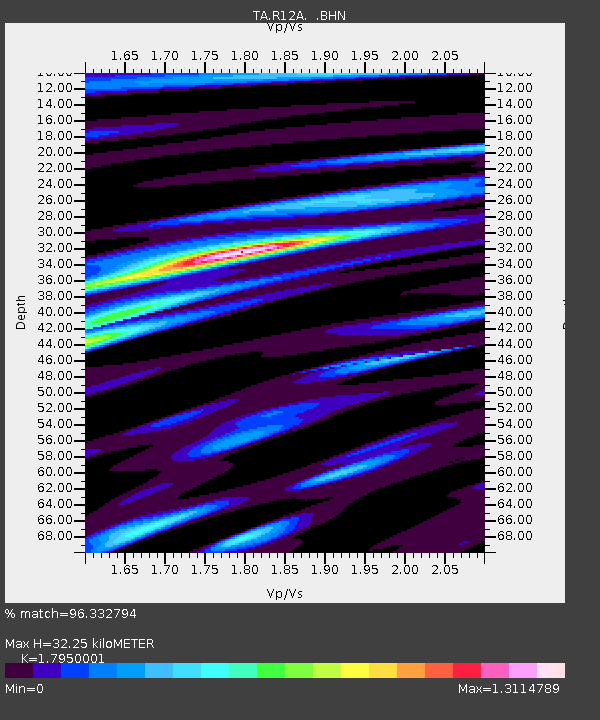
| Estimated Moho Depth: |
32.25 km |
| Estimated Crust Vp/Vs: |
1.80 |
| Assumed Crust Vp: |
6.276 km/s |
| Estimated Crust Vs: |
3.496 km/s |
| Estimated Crust Poisson's Ratio: |
0.27 |
|
| Radial Match: |
96.332794 % |
| Radial Bump: |
400 |
| Transverse Match: |
92.145195 % |
| Transverse Bump: |
400 |
| SOD ConfigId: |
2564 |
| Insert Time: |
2010-03-07 04:12:44.585 +0000 |
| GWidth: |
2.5 |
| Max Bumps: |
400 |
| Tol: |
0.001 |
|
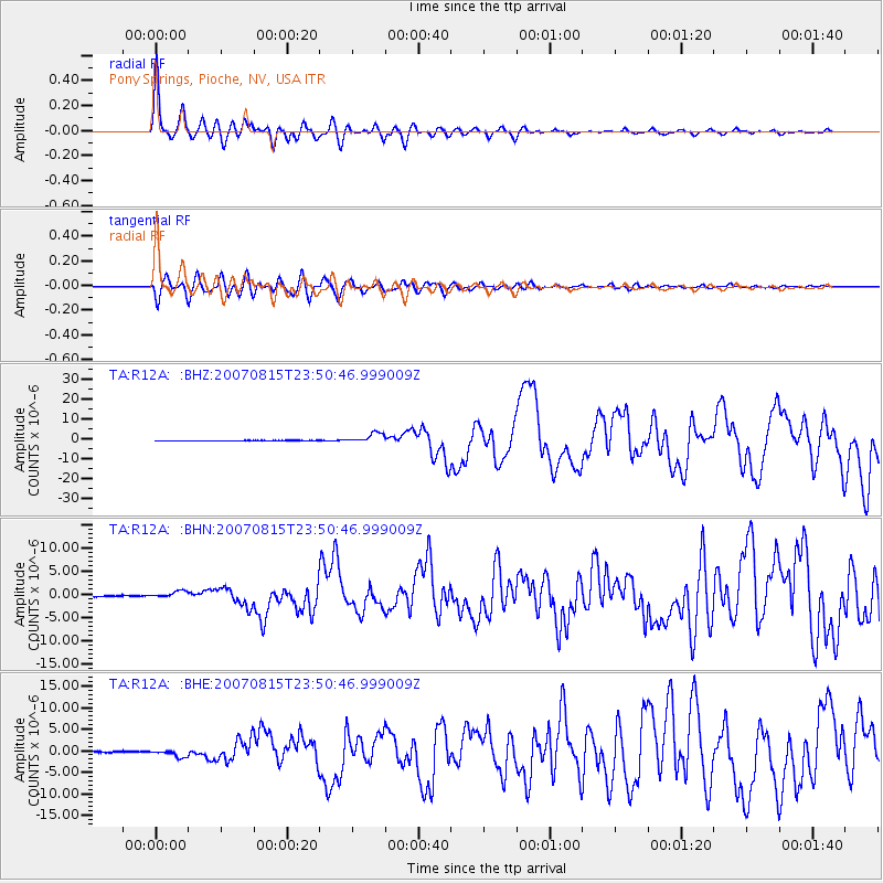
Signal To Noise
| Channel | StoN | STA | LTA |
| TA:R12A: :BHN:20070815T23:50:46.999009Z | 6.369497 | 8.02362E-7 | 1.2596945E-7 |
| TA:R12A: :BHE:20070815T23:50:46.999009Z | 7.8043146 | 8.753627E-7 | 1.1216394E-7 |
| TA:R12A: :BHZ:20070815T23:50:46.999009Z | 27.237108 | 2.5416089E-6 | 9.331419E-8 |
| Arrivals |
| Ps | 4.3 SECOND |
| PpPs | 14 SECOND |
| PsPs/PpSs | 18 SECOND |


