You are here: Home > Network List > TA - USArray Transportable Network (new EarthScope stations) Stations List
> Station R12A Pony Springs, Pioche, NV, USA > Earthquake Result Viewer
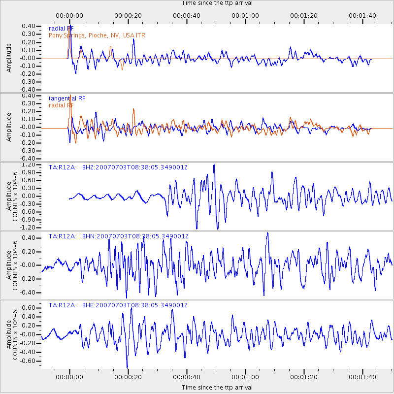
R12A Pony Springs, Pioche, NV, USA - Earthquake Result Viewer

| Earthquake location: |
Central Mid-Atlantic Ridge |
| Earthquake latitude/longitude: |
0.7/-30.3 |
| Earthquake time(UTC): |
2007/07/03 (184) 08:26:00 GMT |
| Earthquake Depth: |
10 km |
| Earthquake Magnitude: |
5.8 MB, 5.9 MS, 6.3 MW, 6.1 MW |
| Earthquake Catalog/Contributor: |
WHDF/NEIC |
|
| Network: |
TA USArray Transportable Network (new EarthScope stations) |
| Station: |
R12A Pony Springs, Pioche, NV, USA |
| Lat/Lon: |
38.33 N/114.61 W |
| Elevation: |
1845 m |
|
| Distance: |
85.1 deg |
| Az: |
308.232 deg |
| Baz: |
92.946 deg |
| Ray Param: |
0.045001455 |
| Estimated Moho Depth: |
34.5 km |
| Estimated Crust Vp/Vs: |
1.75 |
| Assumed Crust Vp: |
6.276 km/s |
| Estimated Crust Vs: |
3.581 km/s |
| Estimated Crust Poisson's Ratio: |
0.26 |
|
| Radial Match: |
80.472664 % |
| Radial Bump: |
400 |
| Transverse Match: |
70.99201 % |
| Transverse Bump: |
400 |
| SOD ConfigId: |
2564 |
| Insert Time: |
2010-03-07 04:12:53.405 +0000 |
| GWidth: |
2.5 |
| Max Bumps: |
400 |
| Tol: |
0.001 |
|
Signal To Noise
| Channel | StoN | STA | LTA |
| TA:R12A: :BHN:20070703T08:38:05.349001Z | 2.0653188 | 8.707077E-8 | 4.2158515E-8 |
| TA:R12A: :BHE:20070703T08:38:05.349001Z | 2.2500846 | 1.2049885E-7 | 5.355303E-8 |
| TA:R12A: :BHZ:20070703T08:38:05.349001Z | 3.2975152 | 2.6723814E-7 | 8.104228E-8 |
| Arrivals |
| Ps | 4.2 SECOND |
| PpPs | 15 SECOND |
| PsPs/PpSs | 19 SECOND |


