You are here: Home > Network List > TA - USArray Transportable Network (new EarthScope stations) Stations List
> Station R12A Pony Springs, Pioche, NV, USA > Earthquake Result Viewer
R12A Pony Springs, Pioche, NV, USA - Earthquake Result Viewer

| Earthquake location: |
Kamchatka Peninsula, Russia |
| Earthquake latitude/longitude: |
52.1/157.3 |
| Earthquake time(UTC): |
2007/05/30 (150) 20:22:12 GMT |
| Earthquake Depth: |
116 km |
| Earthquake Magnitude: |
6.4 MB, 6.4 MW, 6.4 MW |
| Earthquake Catalog/Contributor: |
WHDF/NEIC |
|
| Network: |
TA USArray Transportable Network (new EarthScope stations) |
| Station: |
R12A Pony Springs, Pioche, NV, USA |
| Lat/Lon: |
38.33 N/114.61 W |
| Elevation: |
1845 m |
|
| Distance: |
59.8 deg |
| Az: |
65.386 deg |
| Baz: |
314.565 deg |
| Ray Param: |
0.061583463 |
| Estimated Moho Depth: |
30.5 km |
| Estimated Crust Vp/Vs: |
1.91 |
| Assumed Crust Vp: |
6.276 km/s |
| Estimated Crust Vs: |
3.281 km/s |
| Estimated Crust Poisson's Ratio: |
0.31 |
|
| Radial Match: |
82.31769 % |
| Radial Bump: |
400 |
| Transverse Match: |
81.30877 % |
| Transverse Bump: |
400 |
| SOD ConfigId: |
2564 |
| Insert Time: |
2010-03-07 04:12:58.174 +0000 |
| GWidth: |
2.5 |
| Max Bumps: |
400 |
| Tol: |
0.001 |
|
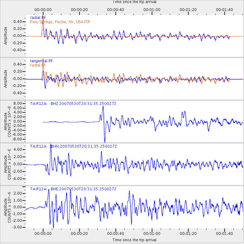
Signal To Noise
| Channel | StoN | STA | LTA |
| TA:R12A: :BHN:20070530T20:31:35.250027Z | 28.945692 | 1.915092E-6 | 6.616156E-8 |
| TA:R12A: :BHE:20070530T20:31:35.250027Z | 13.874558 | 1.1407474E-6 | 8.221864E-8 |
| TA:R12A: :BHZ:20070530T20:31:35.250027Z | 38.552017 | 3.826747E-6 | 9.9261925E-8 |
| Arrivals |
| Ps | 4.6 SECOND |
| PpPs | 14 SECOND |
| PsPs/PpSs | 18 SECOND |


