You are here: Home > Network List > TA - USArray Transportable Network (new EarthScope stations) Stations List
> Station R12A Pony Springs, Pioche, NV, USA > Earthquake Result Viewer
R12A Pony Springs, Pioche, NV, USA - Earthquake Result Viewer
| Earthquake location: |
South Of Panama |
| Earthquake latitude/longitude: |
4.6/-78.5 |
| Earthquake time(UTC): |
2007/03/18 (077) 02:11:05 GMT |
| Earthquake Depth: |
8.0 km |
| Earthquake Magnitude: |
6.4 MB, 5.7 MS, 6.2 MW, 6.1 MW |
| Earthquake Catalog/Contributor: |
WHDF/NEIC |
|
| Network: |
TA USArray Transportable Network (new EarthScope stations) |
| Station: |
R12A Pony Springs, Pioche, NV, USA |
| Lat/Lon: |
38.33 N/114.61 W |
| Elevation: |
1845 m |
|
| Distance: |
47.0 deg |
| Az: |
320.648 deg |
| Baz: |
126.518 deg |
| Ray Param: |
0.07031149 |
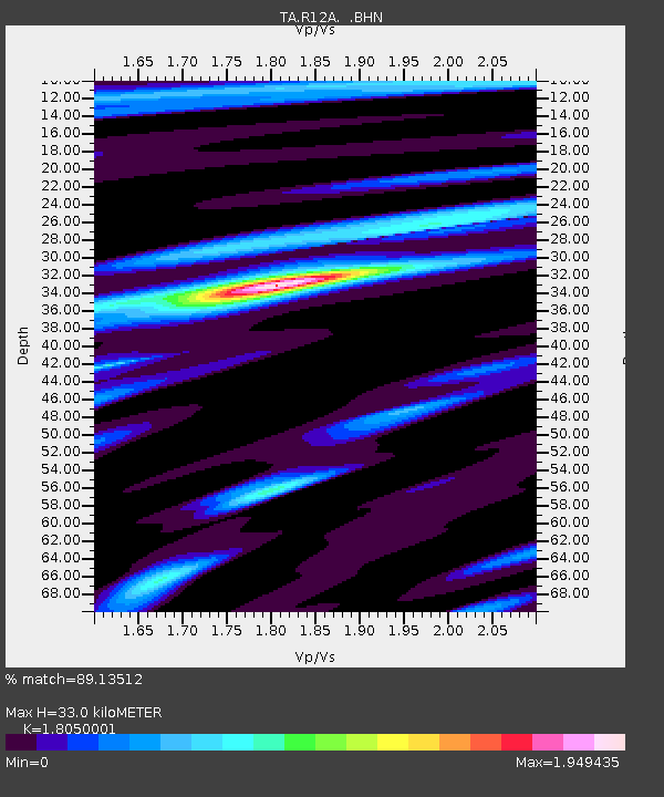
| Estimated Moho Depth: |
33.0 km |
| Estimated Crust Vp/Vs: |
1.81 |
| Assumed Crust Vp: |
6.276 km/s |
| Estimated Crust Vs: |
3.477 km/s |
| Estimated Crust Poisson's Ratio: |
0.28 |
|
| Radial Match: |
89.13512 % |
| Radial Bump: |
400 |
| Transverse Match: |
79.337944 % |
| Transverse Bump: |
400 |
| SOD ConfigId: |
2564 |
| Insert Time: |
2010-03-07 04:13:01.522 +0000 |
| GWidth: |
2.5 |
| Max Bumps: |
400 |
| Tol: |
0.001 |
|
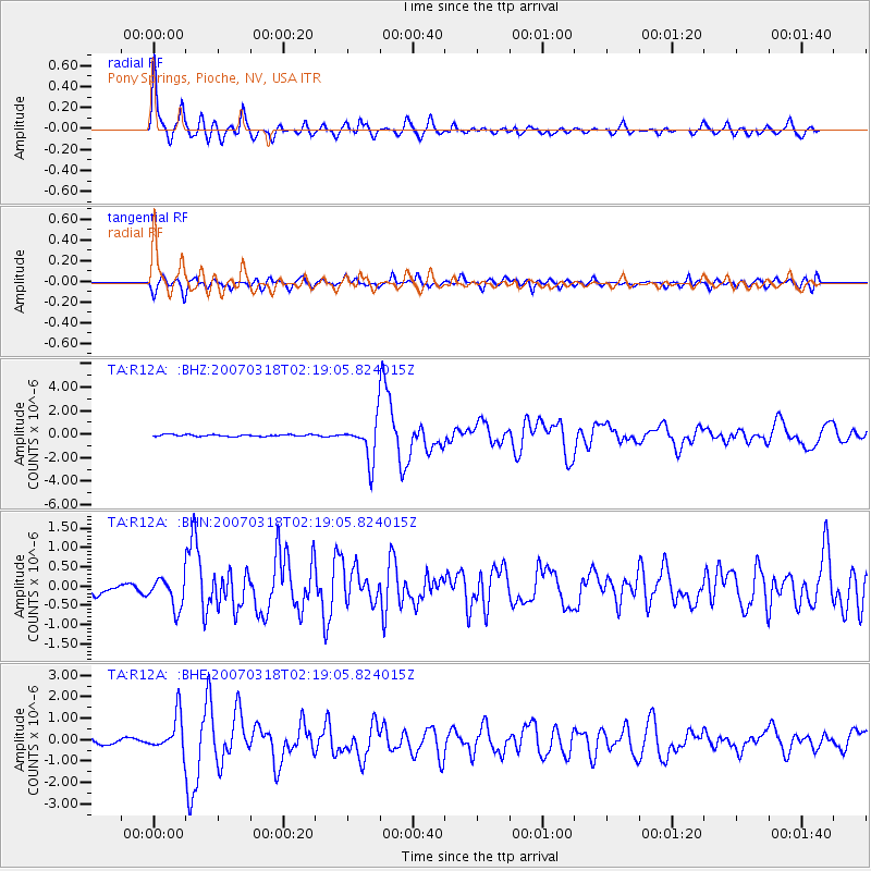
Signal To Noise
| Channel | StoN | STA | LTA |
| TA:R12A: :BHN:20070318T02:19:05.824015Z | 2.8141727 | 3.9127738E-7 | 1.3903815E-7 |
| TA:R12A: :BHE:20070318T02:19:05.824015Z | 4.8497505 | 8.5345704E-7 | 1.7597957E-7 |
| TA:R12A: :BHZ:20070318T02:19:05.824015Z | 22.49643 | 1.6927106E-6 | 7.524353E-8 |
| Arrivals |
| Ps | 4.5 SECOND |
| PpPs | 14 SECOND |
| PsPs/PpSs | 18 SECOND |


