You are here: Home > Network List > TA - USArray Transportable Network (new EarthScope stations) Stations List
> Station O02C Red Bluff, CA, USA > Earthquake Result Viewer
O02C Red Bluff, CA, USA - Earthquake Result Viewer
| Earthquake location: |
Kuril Islands |
| Earthquake latitude/longitude: |
45.8/150.1 |
| Earthquake time(UTC): |
2007/09/03 (246) 16:14:53 GMT |
| Earthquake Depth: |
94 km |
| Earthquake Magnitude: |
6.3 MB, 6.2 MW, 6.2 ME |
| Earthquake Catalog/Contributor: |
WHDF/NEIC |
|
| Network: |
TA USArray Transportable Network (new EarthScope stations) |
| Station: |
O02C Red Bluff, CA, USA |
| Lat/Lon: |
40.18 N/122.79 W |
| Elevation: |
962 m |
|
| Distance: |
60.9 deg |
| Az: |
61.123 deg |
| Baz: |
306.965 deg |
| Ray Param: |
0.06095285 |
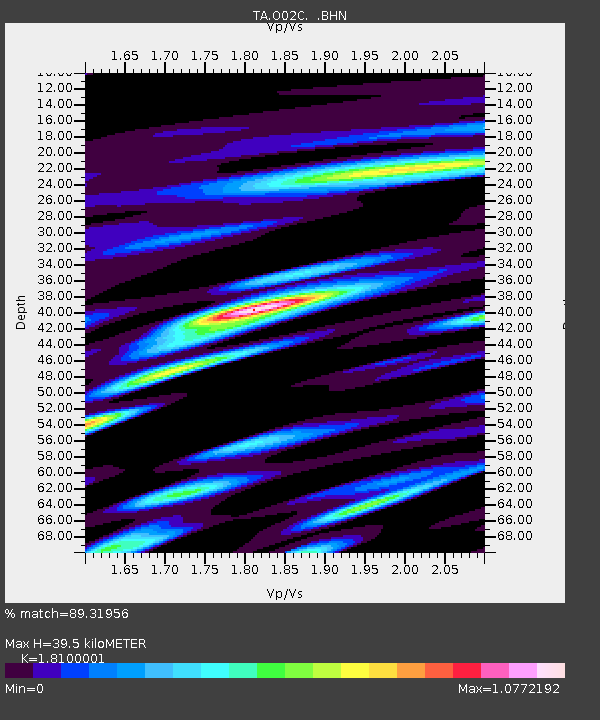
| Estimated Moho Depth: |
39.5 km |
| Estimated Crust Vp/Vs: |
1.81 |
| Assumed Crust Vp: |
6.566 km/s |
| Estimated Crust Vs: |
3.628 km/s |
| Estimated Crust Poisson's Ratio: |
0.28 |
|
| Radial Match: |
89.31956 % |
| Radial Bump: |
388 |
| Transverse Match: |
86.40592 % |
| Transverse Bump: |
400 |
| SOD ConfigId: |
2564 |
| Insert Time: |
2010-03-07 04:14:39.701 +0000 |
| GWidth: |
2.5 |
| Max Bumps: |
400 |
| Tol: |
0.001 |
|
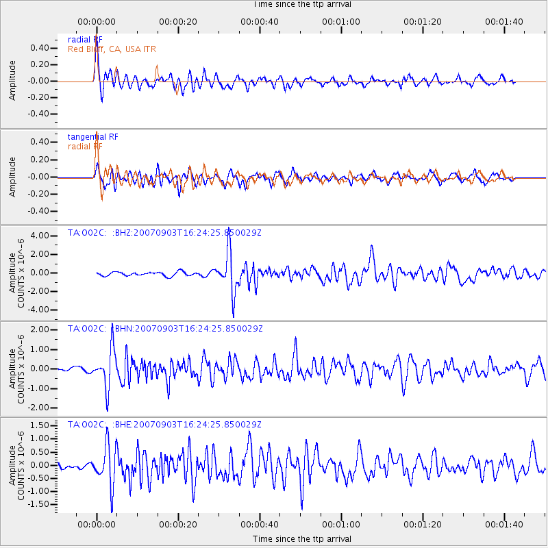
Signal To Noise
| Channel | StoN | STA | LTA |
| TA:O02C: :BHN:20070903T16:24:25.850029Z | 10.035539 | 1.0109026E-6 | 1.00732265E-7 |
| TA:O02C: :BHE:20070903T16:24:25.850029Z | 5.688464 | 7.798373E-7 | 1.37091E-7 |
| TA:O02C: :BHZ:20070903T16:24:25.850029Z | 10.544782 | 2.22224E-6 | 2.1074311E-7 |
| Arrivals |
| Ps | 5.1 SECOND |
| PpPs | 16 SECOND |
| PsPs/PpSs | 21 SECOND |


