
Station TA O02C - Red Bluff, CA, USA
Network: TA - USArray Transportable Network (new EarthScope stations)
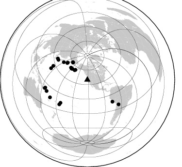
Nearby stations (2 deg radius)
| Station | Name | (Lat, Lon) | Start / End | Elevation |
| O02C | Red Bluff, CA, USA | (40.18, -122.79) | 2005-07-20 / 2499-01-01 | 1.0 km |
| Crust2 Type: | L8,thin continental arc, Cordilleras, 0.5 km seds. |
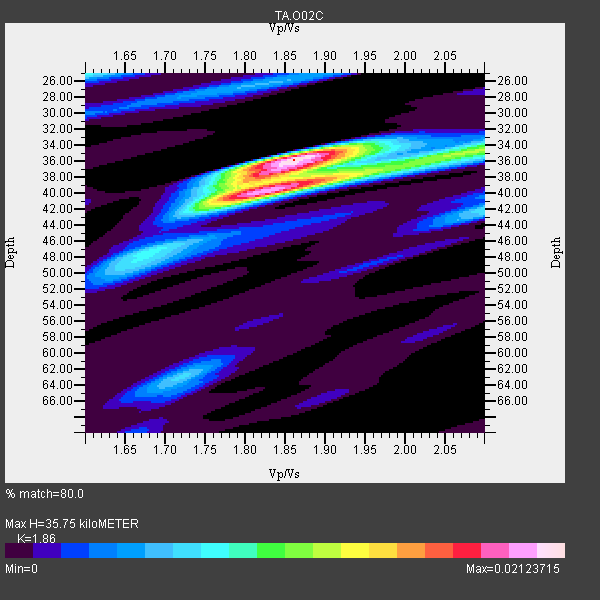
| Thickness Estimate: | 36 km |
| Thickness StdDev: | 1.8 km |
| Vp/Vs Estimate: | 1.86 |
| Vp/Vs StdDev: | 0.06 |
| Vs Estimate: | 3.53 km/s |
| Poisson's Ratio: | 0.30 |
| Peak Value: | 0.02 |
| Assumed Vp: | 6.566 km/s |
| Ps Weight: | 0.33333334 |
| PpPs Weight: | 0.33333334 |
| PsPs Weight: | 0.33333328 |
| Residual Complexity: | 0.688 |
| Nearby stations H: | +- |
| (2.0 deg) Vp/Vs: | +- |
13 with match > 90% ( 54.166668 %) and 24 with match > 80% ( 100.0 %) out of 24.
Download stack as xyz text file.
Azimuth Distribution of Events:
Prior Results for this Station
| Study | Thickness | Vp/Vs | Vp | Vs | Poissons Ratio | Extra |
| EARS | 36 km | 1.86 | 6.566 km/s | 3.53 km/s | 0.30 | |
| Crust2.0 | 34 km | 1.77 | 6.566 km/s | 3.707 km/s | 0.27 | L8,thin continental arc, Cordilleras, 0.5 km seds. |
| Global Maxima | 36 km | 1.86 | 6.566 km/s | 3.53 km/s | 0.30 | amp=0.02123715 |
| Local Maxima 1 | 39 km | 1.85 | 6.566 km/s | 3.554 km/s | 0.29 | amp=0.017019317 |
| Local Maxima 2 | 34 km | 2.10 | 6.566 km/s | 3.13 km/s | 0.35 | amp=0.010715463 |
| Local Maxima 3 | 25 km | 1.60 | 6.566 km/s | 4.104 km/s | 0.18 | amp=0.0076361834 |
| Local Maxima 4 | 42 km | 2.10 | 6.566 km/s | 3.13 km/s | 0.35 | amp=0.0071176994 |
| Predicted Arrivals for vertical incidence (zero ray parameter) | |
| Ps | 4.68 SECOND |
| PpPs | 15.57 SECOND |
| PsPs/PpSs | 20.25 SECOND |
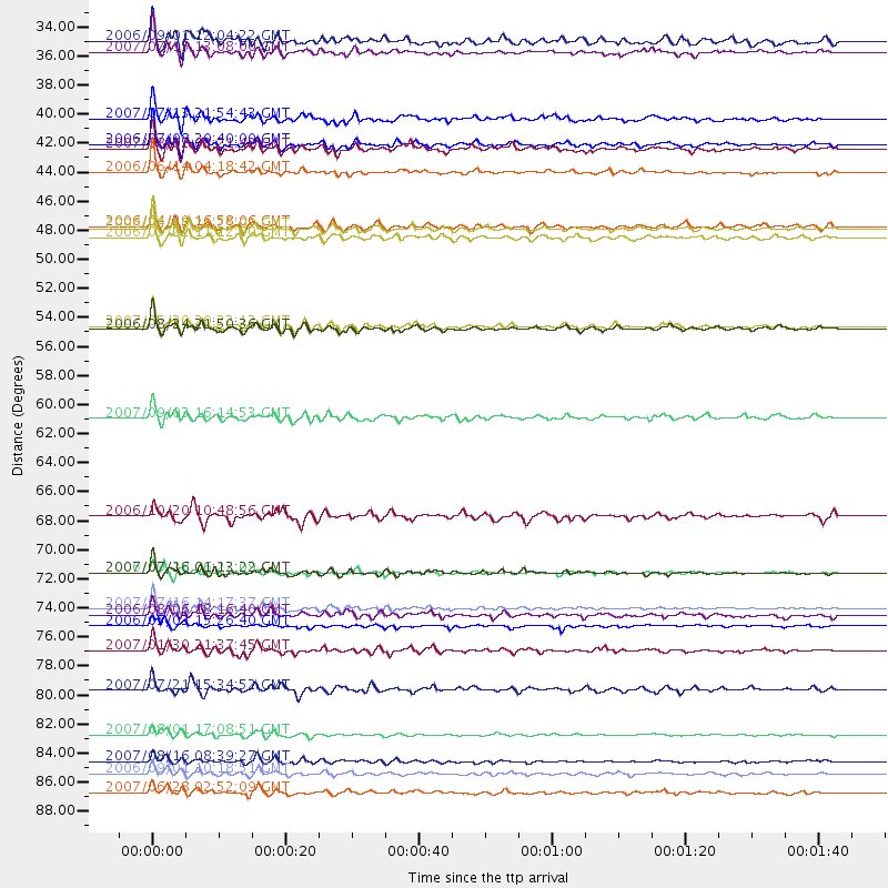
Events Processed for this Station
Download zip of receiver functions as SAC
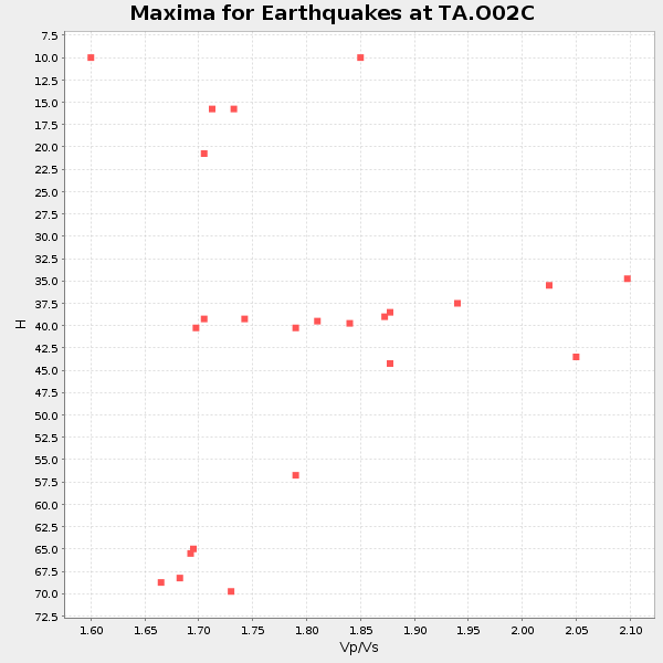
Plot maxima for each earthquake.
Events Used in the Stack
(24 events)| Radial Match | Distance | Baz | FERegion | Time | Lat/Lon | Depth | Magnitude |
| 96.89628 | 53.9 deg | 311.349 deg | Kamchatka Peninsula, Russia | 2007/05/30 20:22:12 GMT | (52.1, 157.3) | 116 km | 6.4 MB, 6.4 MW, 6.4 MW |
| 96.84819 | 72.7 deg | 304.634 deg | Near West Coast Of Honshu, Japan | 2007/07/16 01:13:22 GMT | (37.5, 138.4) | 12 km | 6.5 MB, 6.4 MS, 6.6 MW, 6.5 MW |
| 96.55986 | 76.8 deg | 228.893 deg | Tonga Islands | 2006/05/03 15:26:40 GMT | (-20.2, -174.1) | 55 km | 7.2 MB, 7.8 MS, 7.9 MW, 7.9 MW |
| 93.65527 | 72.7 deg | 229.53 deg | Samoa Islands Region | 2006/09/28 06:22:09 GMT | (-16.6, -172.0) | 28 km | 6.5 MB, 6.6 MS, 6.9 MW, 6.7 MW |
| 92.987724 | 75.4 deg | 305.9 deg | Sea Of Japan | 2007/07/16 14:17:37 GMT | (36.8, 134.9) | 350 km | 6.2 MB, 6.8 MW, 6.8 MW |
| 92.91533 | 89.5 deg | 259.181 deg | Solomon Islands | 2007/06/28 02:52:09 GMT | (-8.0, 154.6) | 10 km | 6.3 MB, 6.7 MS, 6.7 MW, 6.7 MW |
| 92.71266 | 46.5 deg | 320.765 deg | Eastern Siberia, Russia | 2006/04/20 23:25:02 GMT | (60.9, 167.1) | 22 km | 6.8 MB, 7.6 MS, 7.6 MW, 7.3 MW |
| 92.665726 | 38.1 deg | 306.101 deg | Andreanof Islands, Aleutian Is. | 2007/07/13 21:54:43 GMT | (51.8, -176.3) | 35 km | 5.7 MB, 5.6 MS, 6.0 MW, 5.9 MW |
| 92.65199 | 40.1 deg | 305.391 deg | Andreanof Islands, Aleutian Is. | 2006/07/08 20:40:00 GMT | (51.2, -179.3) | 22 km | 6.2 MB, 6.4 MS, 6.6 MW, 6.6 MW |
| 92.30532 | 54.2 deg | 310.145 deg | Near East Coast Of Kamchatka | 2006/08/24 21:50:36 GMT | (51.1, 157.5) | 43 km | 5.9 MB, 6.2 MS, 6.5 MW, 6.5 MW |
| 92.210655 | 85.0 deg | 244.987 deg | Vanuatu Islands | 2007/08/01 17:08:51 GMT | (-15.6, 167.7) | 120 km | 6.2 MB, 7.2 MW, 7.2 MW |
| 92.19024 | 87.1 deg | 254.649 deg | Solomon Islands | 2007/08/16 08:39:27 GMT | (-9.8, 159.5) | 10 km | 6.1 MB, 6.7 MS, 6.4 MW |
| 90.46825 | 40.5 deg | 305.611 deg | Andreanof Islands, Aleutian Is. | 2007/08/02 03:21:42 GMT | (51.3, -180.0) | 21 km | 6.3 MB, 6.6 MS, 6.7 MW, 6.6 MW |
| 89.31956 | 60.9 deg | 306.965 deg | Kuril Islands | 2007/09/03 16:14:53 GMT | (45.8, 150.1) | 94 km | 6.3 MB, 6.2 MW, 6.2 ME |
| 86.28274 | 42.2 deg | 306.66 deg | Rat Islands, Aleutian Islands | 2006/06/14 04:18:42 GMT | (51.8, 177.1) | 14 km | 5.9 MB, 6.4 MS, 6.4 MW, 6.4 MW |
| 85.94595 | 75.9 deg | 292.28 deg | Bonin Islands, Japan Region | 2006/08/06 18:16:40 GMT | (26.1, 144.0) | 23 km | 6.0 MB, 5.6 MS, 5.8 MW, 5.8 MW |
| 85.701416 | 78.6 deg | 287.767 deg | Mariana Islands | 2007/01/30 21:37:45 GMT | (21.0, 144.7) | 30 km | 6.3 MB, 6.5 MS, 6.6 MW, 6.5 MW |
| 85.594055 | 46.4 deg | 320.1 deg | Eastern Siberia, Russia | 2006/04/29 16:58:06 GMT | (60.5, 167.5) | 11 km | 6.4 MB, 6.6 MS, 6.6 MW, 6.4 MW |
| 85.08098 | 68.4 deg | 131.051 deg | Near Coast Of Peru | 2006/10/20 10:48:56 GMT | (-13.5, -76.7) | 23 km | 5.9 MB, 6.6 MS, 6.7 MW, 6.6 MW |
| 84.49552 | 81.6 deg | 128.186 deg | Jujuy Province, Argentina | 2007/07/21 15:34:52 GMT | (-22.2, -65.8) | 290 km | 5.8 MB, 6.4 MW, 6.3 MW |
| 83.53096 | 33.0 deg | 307.179 deg | Fox Islands, Aleutian Islands | 2007/07/15 13:08:00 GMT | (52.5, -168.0) | 10 km | 5.8 MB, 5.9 MS, 6.1 MW, 6.0 MW |
| 82.43725 | 88.0 deg | 259.524 deg | Solomon Islands | 2006/09/01 10:18:51 GMT | (-6.8, 155.5) | 38 km | 6.3 MB, 6.7 MS, 6.8 MW, 6.7 MW |
| 81.43939 | 47.2 deg | 320.638 deg | Eastern Siberia, Russia | 2006/05/22 11:12:00 GMT | (60.8, 165.7) | 16 km | 6.0 MB, 6.7 MS, 6.6 MW, 6.5 MW |
| 81.213356 | 32.2 deg | 310.113 deg | Fox Islands, Aleutian Islands | 2006/09/01 12:04:22 GMT | (54.0, -166.4) | 76 km | 5.8 MB, 5.9 MW |
Losers
(0 events)| Radial Match | Distance | Baz | FERegion | Time | Lat/Lon | Depth | Magnitude | Reason |
