You are here: Home > Network List > TA - USArray Transportable Network (new EarthScope stations) Stations List
> Station O02C Red Bluff, CA, USA > Earthquake Result Viewer
O02C Red Bluff, CA, USA - Earthquake Result Viewer
| Earthquake location: |
Near Coast Of Peru |
| Earthquake latitude/longitude: |
-13.5/-76.7 |
| Earthquake time(UTC): |
2006/10/20 (293) 10:48:56 GMT |
| Earthquake Depth: |
23 km |
| Earthquake Magnitude: |
5.9 MB, 6.6 MS, 6.7 MW, 6.6 MW |
| Earthquake Catalog/Contributor: |
WHDF/NEIC |
|
| Network: |
TA USArray Transportable Network (new EarthScope stations) |
| Station: |
O02C Red Bluff, CA, USA |
| Lat/Lon: |
40.18 N/122.79 W |
| Elevation: |
962 m |
|
| Distance: |
68.4 deg |
| Az: |
323.566 deg |
| Baz: |
131.051 deg |
| Ray Param: |
0.0563032 |
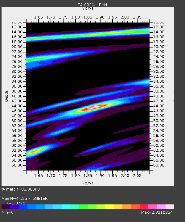
| Estimated Moho Depth: |
44.25 km |
| Estimated Crust Vp/Vs: |
1.88 |
| Assumed Crust Vp: |
6.566 km/s |
| Estimated Crust Vs: |
3.497 km/s |
| Estimated Crust Poisson's Ratio: |
0.30 |
|
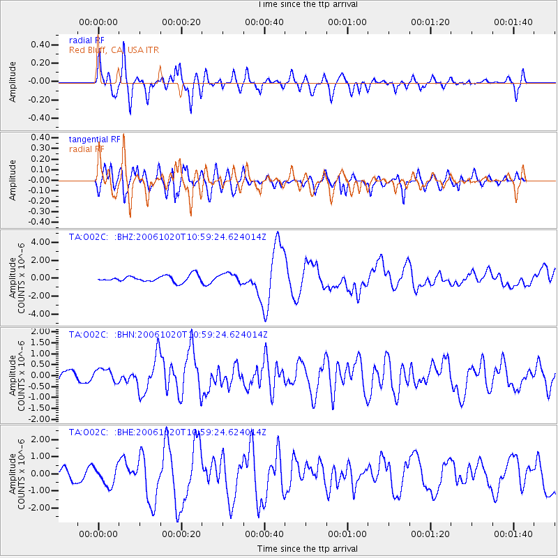
| Radial Match: |
85.08098 % |
| Radial Bump: |
400 |
| Transverse Match: |
77.1971 % |
| Transverse Bump: |
400 |
| SOD ConfigId: |
2665 |
| Insert Time: |
2010-03-07 04:14:51.018 +0000 |
| GWidth: |
2.5 |
| Max Bumps: |
400 |
| Tol: |
0.001 |
|
Signal To Noise
| Channel | StoN | STA | LTA |
| TA:O02C: :BHN:20061020T10:59:24.624014Z | 1.4186676 | 3.083117E-7 | 2.1732484E-7 |
| TA:O02C: :BHE:20061020T10:59:24.624014Z | 1.9863055 | 5.410972E-7 | 2.724139E-7 |
| TA:O02C: :BHZ:20061020T10:59:24.624014Z | 1.4680611 | 5.295191E-7 | 3.6069284E-7 |
| Arrivals |
| Ps | 6.1 SECOND |
| PpPs | 19 SECOND |
| PsPs/PpSs | 25 SECOND |


