You are here: Home > Network List > TA - USArray Transportable Network (new EarthScope stations) Stations List
> Station O02C Red Bluff, CA, USA > Earthquake Result Viewer
O02C Red Bluff, CA, USA - Earthquake Result Viewer

| Earthquake location: |
Samoa Islands Region |
| Earthquake latitude/longitude: |
-16.6/-172.0 |
| Earthquake time(UTC): |
2006/09/28 (271) 06:22:09 GMT |
| Earthquake Depth: |
28 km |
| Earthquake Magnitude: |
6.5 MB, 6.6 MS, 6.9 MW, 6.7 MW |
| Earthquake Catalog/Contributor: |
WHDF/NEIC |
|
| Network: |
TA USArray Transportable Network (new EarthScope stations) |
| Station: |
O02C Red Bluff, CA, USA |
| Lat/Lon: |
40.18 N/122.79 W |
| Elevation: |
962 m |
|
| Distance: |
72.7 deg |
| Az: |
37.436 deg |
| Baz: |
229.53 deg |
| Ray Param: |
0.053446583 |
| Estimated Moho Depth: |
15.75 km |
| Estimated Crust Vp/Vs: |
1.71 |
| Assumed Crust Vp: |
6.566 km/s |
| Estimated Crust Vs: |
3.834 km/s |
| Estimated Crust Poisson's Ratio: |
0.24 |
|
| Radial Match: |
93.65527 % |
| Radial Bump: |
400 |
| Transverse Match: |
89.85455 % |
| Transverse Bump: |
400 |
| SOD ConfigId: |
2665 |
| Insert Time: |
2010-03-07 04:14:52.643 +0000 |
| GWidth: |
2.5 |
| Max Bumps: |
400 |
| Tol: |
0.001 |
|
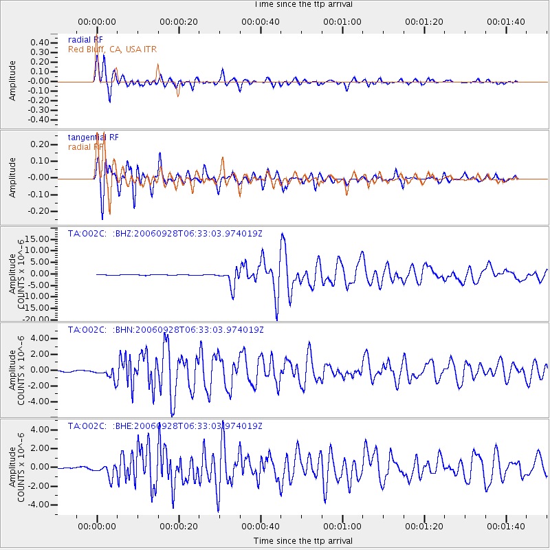
Signal To Noise
| Channel | StoN | STA | LTA |
| TA:O02C: :BHN:20060928T06:33:03.974019Z | 4.263269 | 7.870533E-7 | 1.8461263E-7 |
| TA:O02C: :BHE:20060928T06:33:03.974019Z | 9.025341 | 7.0650833E-7 | 7.828051E-8 |
| TA:O02C: :BHZ:20060928T06:33:03.974019Z | 26.91999 | 3.83587E-6 | 1.424915E-7 |
| Arrivals |
| Ps | 1.8 SECOND |
| PpPs | 6.3 SECOND |
| PsPs/PpSs | 8.0 SECOND |


