You are here: Home > Network List > TA - USArray Transportable Network (new EarthScope stations) Stations List
> Station O02C Red Bluff, CA, USA > Earthquake Result Viewer
O02C Red Bluff, CA, USA - Earthquake Result Viewer

| Earthquake location: |
Near East Coast Of Kamchatka |
| Earthquake latitude/longitude: |
51.1/157.5 |
| Earthquake time(UTC): |
2006/08/24 (236) 21:50:36 GMT |
| Earthquake Depth: |
43 km |
| Earthquake Magnitude: |
5.9 MB, 6.2 MS, 6.5 MW, 6.5 MW |
| Earthquake Catalog/Contributor: |
WHDF/NEIC |
|
| Network: |
TA USArray Transportable Network (new EarthScope stations) |
| Station: |
O02C Red Bluff, CA, USA |
| Lat/Lon: |
40.18 N/122.79 W |
| Elevation: |
962 m |
|
| Distance: |
54.2 deg |
| Az: |
68.414 deg |
| Baz: |
310.145 deg |
| Ray Param: |
0.06552885 |
| Estimated Moho Depth: |
35.5 km |
| Estimated Crust Vp/Vs: |
2.03 |
| Assumed Crust Vp: |
6.566 km/s |
| Estimated Crust Vs: |
3.243 km/s |
| Estimated Crust Poisson's Ratio: |
0.34 |
|
| Radial Match: |
92.30532 % |
| Radial Bump: |
400 |
| Transverse Match: |
82.464714 % |
| Transverse Bump: |
400 |
| SOD ConfigId: |
2665 |
| Insert Time: |
2010-03-07 04:15:03.371 +0000 |
| GWidth: |
2.5 |
| Max Bumps: |
400 |
| Tol: |
0.001 |
|
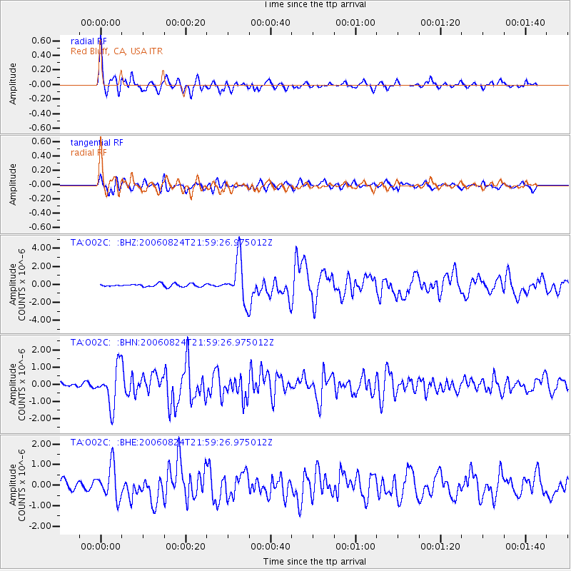
Signal To Noise
| Channel | StoN | STA | LTA |
| TA:O02C: :BHN:20060824T21:59:26.975012Z | 8.897195 | 1.1650503E-6 | 1.3094579E-7 |
| TA:O02C: :BHE:20060824T21:59:26.975012Z | 4.756954 | 8.2025616E-7 | 1.7243306E-7 |
| TA:O02C: :BHZ:20060824T21:59:26.975012Z | 15.54295 | 2.4150959E-6 | 1.5538208E-7 |
| Arrivals |
| Ps | 5.8 SECOND |
| PpPs | 16 SECOND |
| PsPs/PpSs | 21 SECOND |


