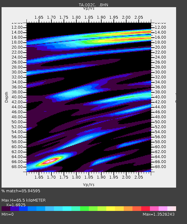
O02C Red Bluff, CA, USA - Earthquake Result Viewer

Earthquake location: Bonin Islands, Japan Region
Earthquake latitude/longitude: 26.1/144.0
Earthquake time(UTC): 2006/08/06 (218) 18:16:40 GMT
Earthquake Depth: 23 km
Earthquake Magnitude: 6.0 MB, 5.6 MS, 5.8 MW, 5.8 MW
Earthquake Catalog/Contributor: WHDF/NEIC
Network: TA USArray Transportable Network (new EarthScope stations)
Station: O02C Red Bluff, CA, USA
Lat/Lon: 40.18 N/122.79 W
Elevation: 962 m
Distance: 75.9 deg
Az: 52.056 deg
Baz: 292.28 deg
Ray Param: 0.05130206
Estimated Moho Depth: 65.5 km
Estimated Crust Vp/Vs: 1.69
Assumed Crust Vp: 6.566 km/s
Estimated Crust Vs: 3.88 km/s
Estimated Crust Poisson's Ratio: 0.23
Radial Match: 85.94595 %
Radial Bump: 400
Transverse Match: 73.07977 %
Transverse Bump: 400
SOD ConfigId: 2665
Insert Time: 2010-03-07 04:15:05.121 +0000
GWidth: 2.5
Max Bumps: 400
Tol: 0.001

Signal To Noise

ChannelStoNSTALTA
TA:O02C: :BHN:20060806T18:27:53.774004Z1.91671263.178631E-71.6583765E-7
TA:O02C: :BHE:20060806T18:27:53.774004Z4.27745683.8925268E-79.100096E-8
TA:O02C: :BHZ:20060806T18:27:53.774004Z7.18715951.0469532E-61.4566997E-7
Arrivals
Ps7.2 SECOND
PpPs26 SECOND
PsPs/PpSs33 SECOND