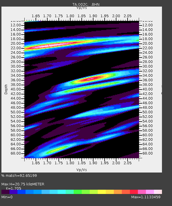
O02C Red Bluff, CA, USA - Earthquake Result Viewer
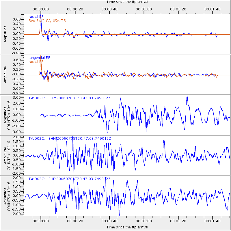
Earthquake location: Andreanof Islands, Aleutian Is.
Earthquake latitude/longitude: 51.2/-179.3
Earthquake time(UTC): 2006/07/08 (189) 20:40:00 GMT
Earthquake Depth: 22 km
Earthquake Magnitude: 6.2 MB, 6.4 MS, 6.6 MW, 6.6 MW
Earthquake Catalog/Contributor: WHDF/NEIC
Network: TA USArray Transportable Network (new EarthScope stations)
Station: O02C Red Bluff, CA, USA
Lat/Lon: 40.18 N/122.79 W
Elevation: 962 m
Distance: 40.1 deg
Az: 83.252 deg
Baz: 305.391 deg
Ray Param: 0.07458182
Estimated Moho Depth: 20.75 km
Estimated Crust Vp/Vs: 1.71
Assumed Crust Vp: 6.566 km/s
Estimated Crust Vs: 3.851 km/s
Estimated Crust Poisson's Ratio: 0.24
Radial Match: 92.65199 %
Radial Bump: 400
Transverse Match: 84.39322 %
Transverse Bump: 400
SOD ConfigId: 2665
Insert Time: 2010-03-07 04:15:06.589 +0000
GWidth: 2.5
Max Bumps: 400
Tol: 0.001

Signal To Noise

ChannelStoNSTALTA
TA:O02C: :BHN:20060708T20:47:03.749012Z2.78693682.655151E-79.52713E-8
TA:O02C: :BHE:20060708T20:47:03.749012Z1.59049361.9347725E-71.2164605E-7
TA:O02C: :BHZ:20060708T20:47:03.749012Z4.50235374.9455866E-71.0984448E-7
Arrivals
Ps2.4 SECOND
PpPs7.9 SECOND
PsPs/PpSs10 SECOND