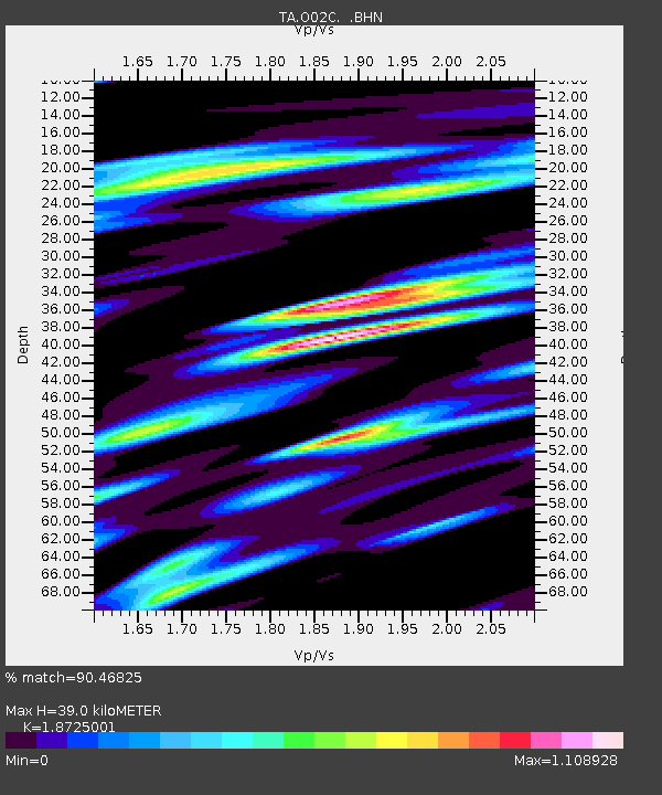
O02C Red Bluff, CA, USA - Earthquake Result Viewer
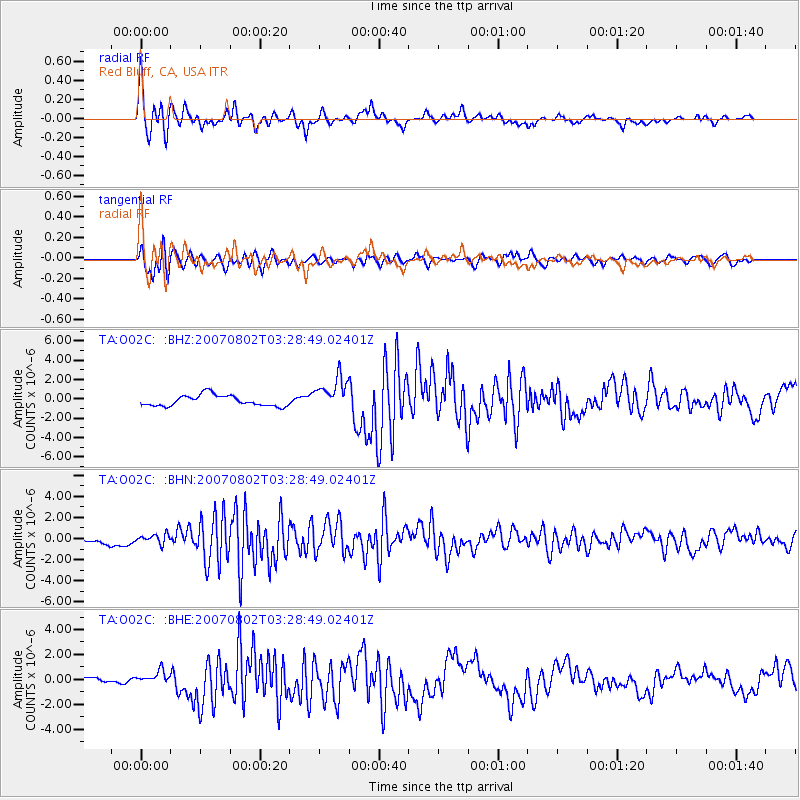
Earthquake location: Andreanof Islands, Aleutian Is.
Earthquake latitude/longitude: 51.3/-180.0
Earthquake time(UTC): 2007/08/02 (214) 03:21:42 GMT
Earthquake Depth: 21 km
Earthquake Magnitude: 6.3 MB, 6.6 MS, 6.7 MW, 6.6 MW
Earthquake Catalog/Contributor: WHDF/NEIC
Network: TA USArray Transportable Network (new EarthScope stations)
Station: O02C Red Bluff, CA, USA
Lat/Lon: 40.18 N/122.79 W
Elevation: 962 m
Distance: 40.5 deg
Az: 82.907 deg
Baz: 305.611 deg
Ray Param: 0.074363045
Estimated Moho Depth: 39.0 km
Estimated Crust Vp/Vs: 1.87
Assumed Crust Vp: 6.566 km/s
Estimated Crust Vs: 3.507 km/s
Estimated Crust Poisson's Ratio: 0.30
Radial Match: 90.46825 %
Radial Bump: 400
Transverse Match: 75.51399 %
Transverse Bump: 400
SOD ConfigId: 2564
Insert Time: 2010-03-07 04:15:12.947 +0000
GWidth: 2.5
Max Bumps: 400
Tol: 0.001

Signal To Noise

ChannelStoNSTALTA
TA:O02C: :BHN:20070802T03:28:49.02401Z0.94370234.4821476E-74.749536E-7
TA:O02C: :BHE:20070802T03:28:49.02401Z2.4728725.3472615E-72.162369E-7
TA:O02C: :BHZ:20070802T03:28:49.02401Z3.06964371.7039245E-65.5508866E-7
Arrivals
Ps5.6 SECOND
PpPs16 SECOND
PsPs/PpSs21 SECOND