You are here: Home > Network List > TA - USArray Transportable Network (new EarthScope stations) Stations List
> Station O02C Red Bluff, CA, USA > Earthquake Result Viewer
O02C Red Bluff, CA, USA - Earthquake Result Viewer

| Earthquake location: |
Vanuatu Islands |
| Earthquake latitude/longitude: |
-15.6/167.7 |
| Earthquake time(UTC): |
2007/08/01 (213) 17:08:51 GMT |
| Earthquake Depth: |
120 km |
| Earthquake Magnitude: |
6.2 MB, 7.2 MW, 7.2 MW |
| Earthquake Catalog/Contributor: |
WHDF/NEIC |
|
| Network: |
TA USArray Transportable Network (new EarthScope stations) |
| Station: |
O02C Red Bluff, CA, USA |
| Lat/Lon: |
40.18 N/122.79 W |
| Elevation: |
962 m |
|
| Distance: |
85.0 deg |
| Az: |
46.097 deg |
| Baz: |
244.987 deg |
| Ray Param: |
0.044786982 |
| Estimated Moho Depth: |
10.0 km |
| Estimated Crust Vp/Vs: |
1.85 |
| Assumed Crust Vp: |
6.566 km/s |
| Estimated Crust Vs: |
3.549 km/s |
| Estimated Crust Poisson's Ratio: |
0.29 |
|
| Radial Match: |
92.210655 % |
| Radial Bump: |
400 |
| Transverse Match: |
91.53589 % |
| Transverse Bump: |
400 |
| SOD ConfigId: |
2564 |
| Insert Time: |
2010-03-07 04:15:15.672 +0000 |
| GWidth: |
2.5 |
| Max Bumps: |
400 |
| Tol: |
0.001 |
|
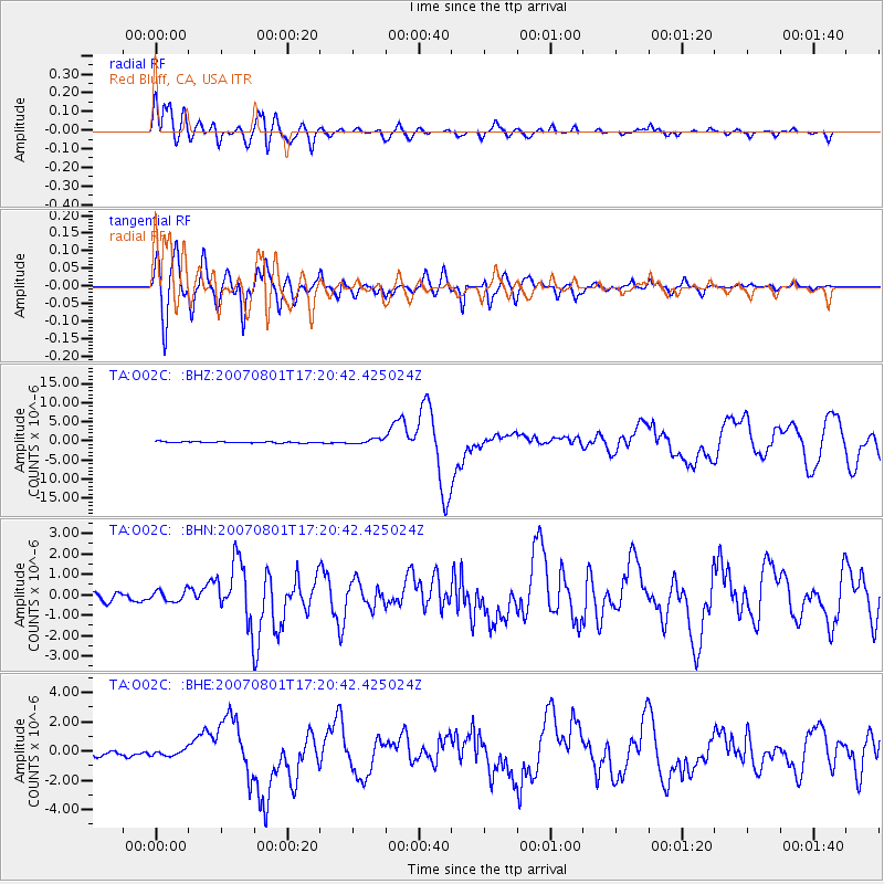
Signal To Noise
| Channel | StoN | STA | LTA |
| TA:O02C: :BHN:20070801T17:20:42.425024Z | 1.6373557 | 2.7186192E-7 | 1.6603718E-7 |
| TA:O02C: :BHE:20070801T17:20:42.425024Z | 0.9050044 | 1.9432288E-7 | 2.1472037E-7 |
| TA:O02C: :BHZ:20070801T17:20:42.425024Z | 3.5802364 | 6.2927046E-7 | 1.7576227E-7 |
| Arrivals |
| Ps | 1.3 SECOND |
| PpPs | 4.2 SECOND |
| PsPs/PpSs | 5.6 SECOND |


