O02C Red Bluff, CA, USA - Earthquake Result Viewer
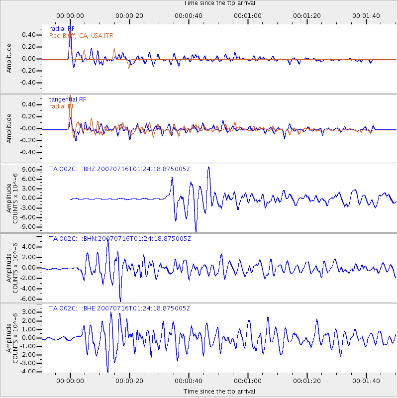
Earthquake location: Near West Coast Of Honshu, Japan
Earthquake latitude/longitude: 37.5/138.4
Earthquake time(UTC): 2007/07/16 (197) 01:13:22 GMT
Earthquake Depth: 12 km
Earthquake Magnitude: 6.5 MB, 6.4 MS, 6.6 MW, 6.5 MW
Earthquake Catalog/Contributor: WHDF/NEIC
Network: TA USArray Transportable Network (new EarthScope stations)
Station: O02C Red Bluff, CA, USA
Lat/Lon: 40.18 N/122.79 W
Elevation: 962 m
Distance: 72.7 deg
Az: 52.47 deg
Baz: 304.634 deg
Ray Param: 0.0534711
Estimated Moho Depth: 68.75 km
Estimated Crust Vp/Vs: 1.66
Assumed Crust Vp: 6.566 km/s
Estimated Crust Vs: 3.944 km/s
Estimated Crust Poisson's Ratio: 0.22
Radial Match: 96.84819 %
Radial Bump: 279
Transverse Match: 93.81049 %
Transverse Bump: 400
SOD ConfigId: 2564
Insert Time: 2010-03-07 04:15:22.758 +0000
GWidth: 2.5
Max Bumps: 400
Tol: 0.001

Signal To Noise

ChannelStoNSTALTA
TA:O02C: :BHN:20070716T01:24:18.875005Z7.03434377.0091653E-79.964206E-8
TA:O02C: :BHE:20070716T01:24:18.875005Z7.91359955.169039E-76.531844E-8
TA:O02C: :BHZ:20070716T01:24:18.875005Z24.7374822.22059E-68.976621E-8
Arrivals
Ps7.2 SECOND
PpPs27 SECOND
PsPs/PpSs34 SECOND