You are here: Home > Network List > TA - USArray Transportable Network (new EarthScope stations) Stations List
> Station O03C Acorn Hollow, Los Molinos, CA, USA > Earthquake Result Viewer
O03C Acorn Hollow, Los Molinos, CA, USA - Earthquake Result Viewer
| Earthquake location: |
Northern Peru |
| Earthquake latitude/longitude: |
-5.7/-76.4 |
| Earthquake time(UTC): |
2005/09/26 (269) 01:55:37 GMT |
| Earthquake Depth: |
115 km |
| Earthquake Magnitude: |
6.7 MB, 7.5 MW, 7.5 MW |
| Earthquake Catalog/Contributor: |
WHDF/NEIC |
|
| Network: |
TA USArray Transportable Network (new EarthScope stations) |
| Station: |
O03C Acorn Hollow, Los Molinos, CA, USA |
| Lat/Lon: |
40.00 N/122.03 W |
| Elevation: |
85 m |
|
| Distance: |
61.9 deg |
| Az: |
321.48 deg |
| Baz: |
126.216 deg |
| Ray Param: |
0.060276926 |
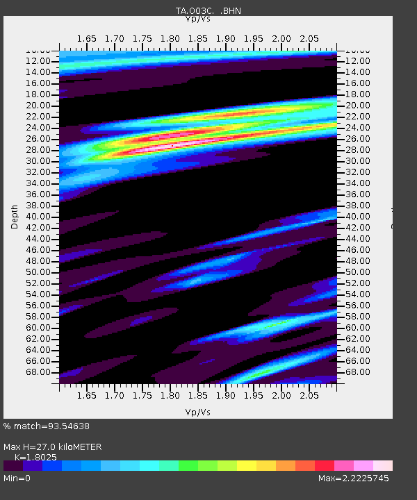
| Estimated Moho Depth: |
27.0 km |
| Estimated Crust Vp/Vs: |
1.80 |
| Assumed Crust Vp: |
6.472 km/s |
| Estimated Crust Vs: |
3.59 km/s |
| Estimated Crust Poisson's Ratio: |
0.28 |
|
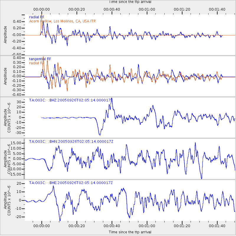
| Radial Match: |
93.54638 % |
| Radial Bump: |
400 |
| Transverse Match: |
78.903786 % |
| Transverse Bump: |
400 |
| SOD ConfigId: |
2475 |
| Insert Time: |
2010-03-07 04:15:39.439 +0000 |
| GWidth: |
2.5 |
| Max Bumps: |
400 |
| Tol: |
0.001 |
|
Signal To Noise
| Channel | StoN | STA | LTA |
| TA:O03C: :BHN:20050926T02:05:14.000017Z | 6.6532335 | 5.822798E-6 | 8.7518316E-7 |
| TA:O03C: :BHE:20050926T02:05:14.000017Z | 6.2548223 | 4.7156886E-6 | 7.539285E-7 |
| TA:O03C: :BHZ:20050926T02:05:14.000017Z | 37.036125 | 1.9243362E-5 | 5.195836E-7 |
| Arrivals |
| Ps | 3.5 SECOND |
| PpPs | 11 SECOND |
| PsPs/PpSs | 15 SECOND |


