
Station TA O03C - Acorn Hollow, Los Molinos, CA, USA
Network: TA - USArray Transportable Network (new EarthScope stations)
Nearby stations (2 deg radius)
| Station | Name | (Lat, Lon) | Start / End | Elevation |
| O03C | Acorn Hollow, Los Molinos, CA, USA | (40.00, -122.03) | 2005-04-19 / 2499-01-01 | 85 m |
| Crust2 Type: | T6,Margin /shield transition, 1 km seds. |
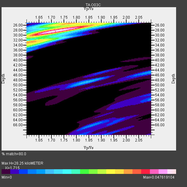
| Thickness Estimate: | 28 km |
| Thickness StdDev: | 11 km |
| Vp/Vs Estimate: | 1.72 |
| Vp/Vs StdDev: | 0.12 |
| Vs Estimate: | 3.774 km/s |
| Poisson's Ratio: | 0.24 |
| Peak Value: | 0.05 |
| Assumed Vp: | 6.472 km/s |
| Ps Weight: | 0.33333334 |
| PpPs Weight: | 0.33333334 |
| PsPs Weight: | 0.33333328 |
| Residual Complexity: | 0.529 |
| Nearby stations H: | +- |
| (2.0 deg) Vp/Vs: | +- |
3 with match > 90% ( 60.0 %) and 5 with match > 80% ( 100.0 %) out of 5.
Download stack as xyz text file.
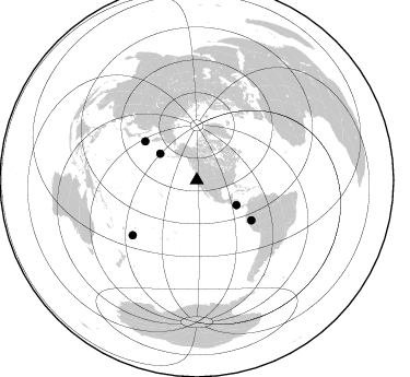
Azimuth Distribution of Events:
Prior Results for this Station
| Study | Thickness | Vp/Vs | Vp | Vs | Poissons Ratio | Extra |
| EARS | 28 km | 1.72 | 6.472 km/s | 3.774 km/s | 0.24 | |
| Crust2.0 | 32 km | 1.79 | 6.472 km/s | 3.622 km/s | 0.27 | T6,Margin /shield transition, 1 km seds. |
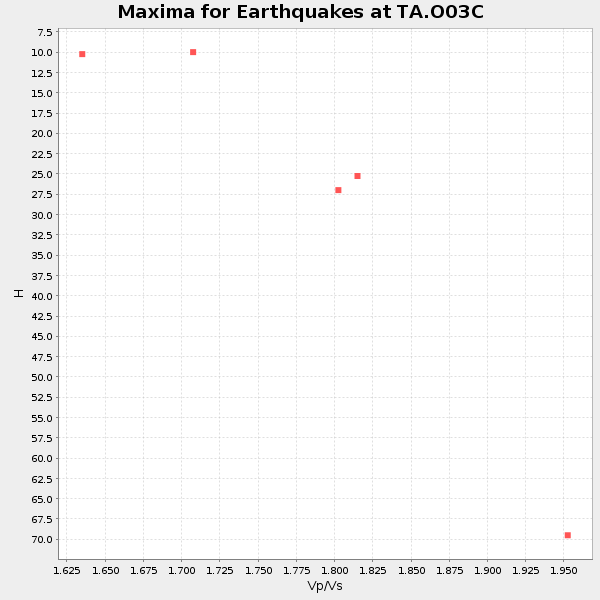
| Global Maxima | 28 km | 1.72 | 6.472 km/s | 3.774 km/s | 0.24 | amp=0.047619104 |
| Local Maxima 1 | 25 km | 1.78 | 6.472 km/s | 3.631 km/s | 0.27 | amp=0.027845375 |
| Local Maxima 2 | 33 km | 1.60 | 6.472 km/s | 4.045 km/s | 0.18 | amp=0.025872782 |
| Local Maxima 3 | 25 km | 1.91 | 6.472 km/s | 3.393 km/s | 0.31 | amp=0.018328276 |
| Local Maxima 4 | 34 km | 1.61 | 6.472 km/s | 4.026 km/s | 0.18 | amp=0.0145221 |
| Predicted Arrivals for vertical incidence (zero ray parameter) | |
| Ps | 3.12 SECOND |
| PpPs | 11.85 SECOND |
| PsPs/PpSs | 14.97 SECOND |
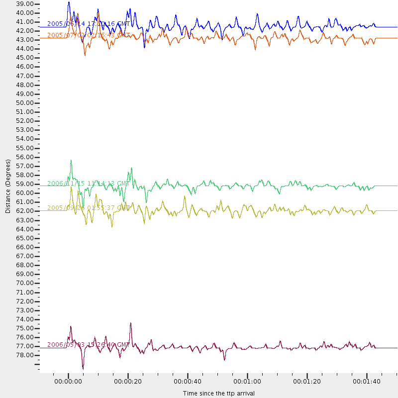
Events Processed for this Station
Download zip of receiver functions as SAC
Plot maxima for each earthquake.
Events Used in the Stack
(5 events)| Radial Match | Distance | Baz | FERegion | Time | Lat/Lon | Depth | Magnitude |
| 95.61499 | 59.2 deg | 306.898 deg | Kuril Islands | 2006/11/15 11:14:13 GMT | (46.6, 153.3) | 10 km | 6.5 MB, 7.8 MS, 8.3 MW, 7.9 MW |
| 94.09463 | 77.1 deg | 229.498 deg | Tonga Islands | 2006/05/03 15:26:40 GMT | (-20.2, -174.1) | 55 km | 7.2 MB, 7.8 MS, 7.9 MW, 7.9 MW |
| 93.54638 | 61.9 deg | 126.216 deg | Northern Peru | 2005/09/26 01:55:37 GMT | (-5.7, -76.4) | 115 km | 6.7 MB, 7.5 MW, 7.5 MW |
| 82.827965 | 42.7 deg | 122.077 deg | Near Coast Of Nicaragua | 2005/07/02 02:16:43 GMT | (11.2, -86.2) | 27 km | 5.6 MB, 6.4 MS, 6.6 MW, 6.6 MW |
| 80.65209 | 41.4 deg | 305.838 deg | Rat Islands, Aleutian Islands | 2005/06/14 17:10:16 GMT | (51.2, 179.4) | 51 km | 6.0 MB, 6.8 MW, 6.6 MW |
Losers
(0 events)| Radial Match | Distance | Baz | FERegion | Time | Lat/Lon | Depth | Magnitude | Reason |
