You are here: Home > Network List > TA - USArray Transportable Network (new EarthScope stations) Stations List
> Station R14A James Farms, Milford, UT, USA > Earthquake Result Viewer
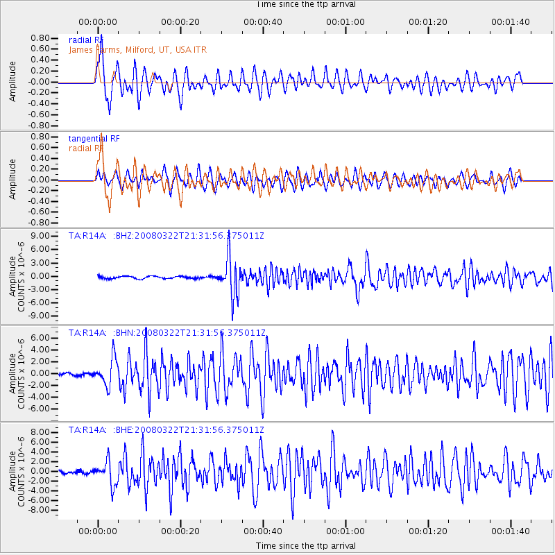
R14A James Farms, Milford, UT, USA - Earthquake Result Viewer

| Earthquake location: |
Andreanof Islands, Aleutian Is. |
| Earthquake latitude/longitude: |
52.2/-178.7 |
| Earthquake time(UTC): |
2008/03/22 (082) 21:24:11 GMT |
| Earthquake Depth: |
132 km |
| Earthquake Magnitude: |
5.8 MB, 6.2 MW, 6.1 MW |
| Earthquake Catalog/Contributor: |
WHDF/NEIC |
|
| Network: |
TA USArray Transportable Network (new EarthScope stations) |
| Station: |
R14A James Farms, Milford, UT, USA |
| Lat/Lon: |
38.30 N/113.02 W |
| Elevation: |
1542 m |
|
| Distance: |
46.7 deg |
| Az: |
80.118 deg |
| Baz: |
309.552 deg |
| Ray Param: |
0.06999357 |
| Estimated Moho Depth: |
12.5 km |
| Estimated Crust Vp/Vs: |
1.60 |
| Assumed Crust Vp: |
6.276 km/s |
| Estimated Crust Vs: |
3.922 km/s |
| Estimated Crust Poisson's Ratio: |
0.18 |
|
| Radial Match: |
80.25846 % |
| Radial Bump: |
400 |
| Transverse Match: |
64.066864 % |
| Transverse Bump: |
400 |
| SOD ConfigId: |
2564 |
| Insert Time: |
2010-03-07 04:15:47.363 +0000 |
| GWidth: |
2.5 |
| Max Bumps: |
400 |
| Tol: |
0.001 |
|
Signal To Noise
| Channel | StoN | STA | LTA |
| TA:R14A: :BHN:20080322T21:31:56.375011Z | 10.534049 | 2.353002E-6 | 2.2337107E-7 |
| TA:R14A: :BHE:20080322T21:31:56.375011Z | 8.483336 | 2.5048193E-6 | 2.9526348E-7 |
| TA:R14A: :BHZ:20080322T21:31:56.375011Z | 16.632452 | 4.3859413E-6 | 2.636978E-7 |
| Arrivals |
| Ps | 1.3 SECOND |
| PpPs | 4.9 SECOND |
| PsPs/PpSs | 6.1 SECOND |


