
Station TA R14A - James Farms, Milford, UT, USA
Network: TA - USArray Transportable Network (new EarthScope stations)
Nearby stations (2 deg radius)
| Station | Name | (Lat, Lon) | Start / End | Elevation |
| R14A | James Farms, Milford, UT, USA | (38.30, -113.02) | 2007-02-27 / 2499-01-01 | 1.5 km |
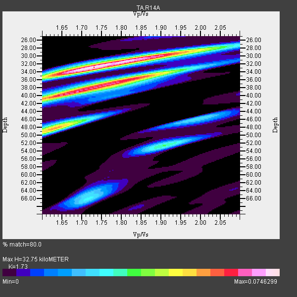
| Crust2 Type: | M5,extended crust, 0.5 km seds. |
| Thickness Estimate: | 33 km |
| Thickness StdDev: | 5.9 km |
| Vp/Vs Estimate: | 1.73 |
| Vp/Vs StdDev: | 0.09 |
| Vs Estimate: | 3.628 km/s |
| Poisson's Ratio: | 0.25 |
| Peak Value: | 0.07 |
| Assumed Vp: | 6.276 km/s |
| Ps Weight: | 0.33333334 |
| PpPs Weight: | 0.33333334 |
| PsPs Weight: | 0.33333328 |
| Residual Complexity: | 0.779 |
| Nearby stations H: | +- |
| (2.0 deg) Vp/Vs: | +- |
5 with match > 90% ( 25.0 %) and 20 with match > 80% ( 100.0 %) out of 20.
Download stack as xyz text file.
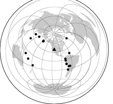
Azimuth Distribution of Events:
Prior Results for this Station
| Study | Thickness | Vp/Vs | Vp | Vs | Poissons Ratio | Extra |
| EARS | 33 km | 1.73 | 6.276 km/s | 3.628 km/s | 0.25 | |
| Crust2.0 | 31 km | 1.78 | 6.276 km/s | 3.529 km/s | 0.27 | M5,extended crust, 0.5 km seds. |
| Global Maxima | 33 km | 1.73 | 6.276 km/s | 3.628 km/s | 0.25 | amp=0.0746299 |
| Local Maxima 1 | 39 km | 1.68 | 6.276 km/s | 3.747 km/s | 0.22 | amp=0.065185316 |
| Local Maxima 2 | 36 km | 1.84 | 6.276 km/s | 3.42 km/s | 0.29 | amp=0.054260407 |
| Local Maxima 3 | 48 km | 1.63 | 6.276 km/s | 3.856 km/s | 0.20 | amp=0.05214405 |
| Local Maxima 4 | 30 km | 1.90 | 6.276 km/s | 3.307 km/s | 0.31 | amp=0.04365169 |
| Predicted Arrivals for vertical incidence (zero ray parameter) | |
| Ps | 3.81 SECOND |
| PpPs | 14.25 SECOND |
| PsPs/PpSs | 18.06 SECOND |
Events Processed for this Station
Download zip of receiver functions as SAC
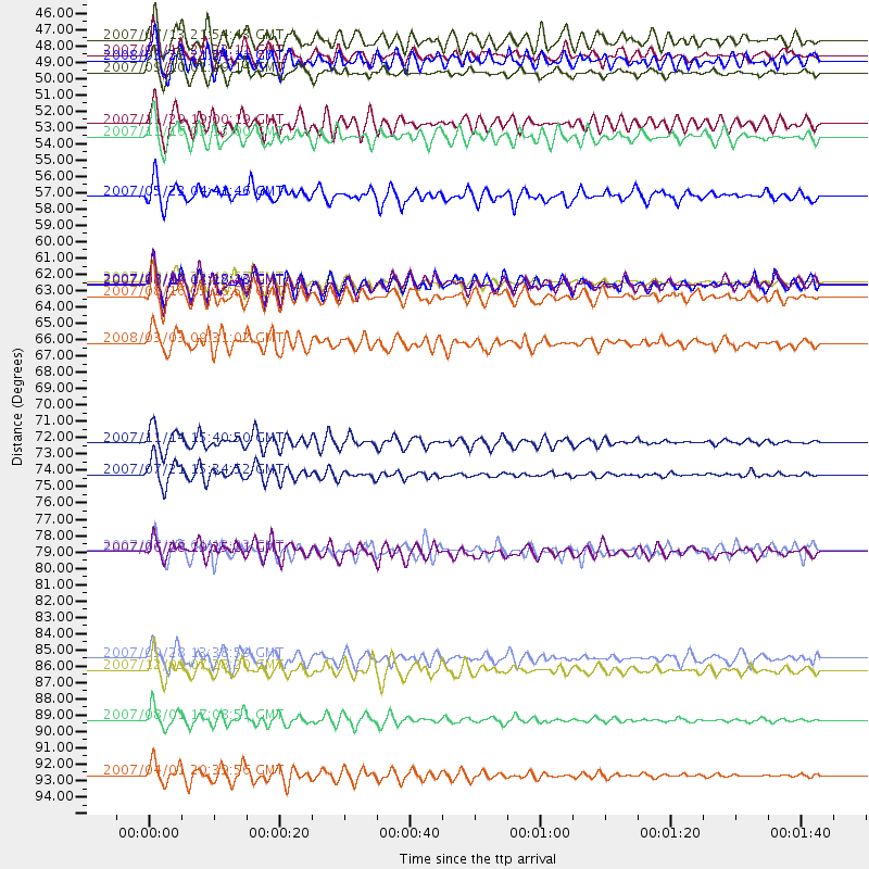
Plot maxima for each earthquake.
Events Used in the Stack
(20 events)| Radial Match | Distance | Baz | FERegion | Time | Lat/Lon | Depth | Magnitude |
| 94.58276 | 72.6 deg | 138.403 deg | Northern Chile | 2007/11/14 15:40:50 GMT | (-22.2, -69.9) | 40 km | 6.7 MB, 7.4 MS, 7.7 MW, 7.4 ME |
| 93.61411 | 95.1 deg | 263.33 deg | Solomon Islands | 2007/04/01 20:39:56 GMT | (-8.5, 157.0) | 10 km | 6.8 MB, 7.9 MS, 8.1 MW, 7.7 ME |
| 92.1156 | 61.7 deg | 138.988 deg | Near Coast Of Peru | 2007/08/15 23:40:57 GMT | (-13.4, -76.6) | 39 km | 6.7 MB, 7.9 MS, 8.0 MW, 7.5 ME |
| 91.679756 | 91.4 deg | 251.292 deg | Vanuatu Islands | 2007/08/01 17:08:51 GMT | (-15.6, 167.7) | 120 km | 6.2 MB, 7.2 MW, 7.2 MW |
| 90.66619 | 87.9 deg | 234.369 deg | South Of Fiji Islands | 2007/12/09 07:28:20 GMT | (-26.0, -177.5) | 152 km | 7.0 MB, 7.8 MW, 7.7 MW |
| 88.85029 | 46.3 deg | 306.852 deg | Andreanof Islands, Aleutian Is. | 2007/08/15 20:22:11 GMT | (50.3, -177.5) | 9.0 km | 6.3 MB, 6.2 MS, 6.4 MW, 5.9 ML |
| 87.34926 | 51.0 deg | 102.423 deg | Windward Islands | 2007/11/29 19:00:19 GMT | (15.0, -61.3) | 148 km | 6.9 MB, 7.4 MW, 7.4 MW |
| 87.054726 | 51.8 deg | 132.93 deg | Peru-Ecuador Border Region | 2007/11/16 03:13:00 GMT | (-2.3, -77.8) | 123 km | 6.3 MB, 6.8 MW, 6.7 MW |
| 86.99176 | 74.7 deg | 135.113 deg | Jujuy Province, Argentina | 2007/07/21 15:34:52 GMT | (-22.2, -65.8) | 290 km | 5.8 MB, 6.4 MW, 6.3 MW |
| 85.79379 | 47.5 deg | 128.965 deg | Near West Coast Of Colombia | 2007/09/10 01:49:14 GMT | (3.0, -78.0) | 31 km | 6.1 MB, 6.7 MS, 6.8 MW |
| 84.5845 | 79.9 deg | 310.037 deg | Near West Coast Of Honshu, Japan | 2007/07/16 01:13:22 GMT | (37.5, 138.4) | 12 km | 6.5 MB, 6.4 MS, 6.6 MW, 6.5 MW |
| 83.52283 | 61.9 deg | 139.144 deg | Near Coast Of Peru | 2007/08/19 01:22:40 GMT | (-13.6, -76.6) | 26 km | 5.9 MB, 5.4 MS, 5.8 MW, 5.5 ML |
| 82.91007 | 62.7 deg | 139.079 deg | Near Coast Of Peru | 2007/08/16 05:16:56 GMT | (-14.3, -76.1) | 23 km | 5.8 MB, 6.1 MS, 6.3 MW, 6.2 ML |
| 82.19725 | 80.0 deg | 144.991 deg | Near Coast Of Central Chile | 2007/06/28 19:25:21 GMT | (-32.0, -71.3) | 69 km | 5.5 MB, 5.7 MW, 5.6 MW |
| 81.61641 | 87.2 deg | 295.809 deg | Volcano Islands, Japan Region | 2007/09/28 13:38:59 GMT | (22.0, 142.7) | 276 km | 6.7 MB, 7.4 MW, 7.4 MW |
| 81.49681 | 45.3 deg | 308.752 deg | Andreanof Islands, Aleutian Is. | 2007/07/13 21:54:43 GMT | (51.8, -176.3) | 35 km | 5.7 MB, 5.6 MS, 6.0 MW, 5.9 MW |
| 81.188805 | 55.9 deg | 47.087 deg | Northern Mid-Atlantic Ridge | 2007/05/23 04:41:46 GMT | (52.4, -31.8) | 10 km | 5.6 MS, 5.4 MB, 5.7 MW, 5.6 MW |
| 80.77655 | 65.8 deg | 310.818 deg | Kuril Islands | 2008/03/03 09:31:02 GMT | (46.4, 153.2) | 10 km | 6.2 MB, 6.5 MS, 6.5 MW, 6.5 MW |
| 80.47281 | 61.9 deg | 139.116 deg | Near Coast Of Peru | 2007/08/17 13:18:13 GMT | (-13.6, -76.6) | 48 km | 5.6 MB, 5.6 MS, 5.9 MW |
| 80.25846 | 46.7 deg | 309.552 deg | Andreanof Islands, Aleutian Is. | 2008/03/22 21:24:11 GMT | (52.2, -178.7) | 132 km | 5.8 MB, 6.2 MW, 6.1 MW |
Losers
(0 events)| Radial Match | Distance | Baz | FERegion | Time | Lat/Lon | Depth | Magnitude | Reason |
