You are here: Home > Network List > TA - USArray Transportable Network (new EarthScope stations) Stations List
> Station R14A James Farms, Milford, UT, USA > Earthquake Result Viewer
R14A James Farms, Milford, UT, USA - Earthquake Result Viewer
| Earthquake location: |
South Of Fiji Islands |
| Earthquake latitude/longitude: |
-26.0/-177.5 |
| Earthquake time(UTC): |
2007/12/09 (343) 07:28:20 GMT |
| Earthquake Depth: |
152 km |
| Earthquake Magnitude: |
7.0 MB, 7.8 MW, 7.7 MW |
| Earthquake Catalog/Contributor: |
WHDF/NEIC |
|
| Network: |
TA USArray Transportable Network (new EarthScope stations) |
| Station: |
R14A James Farms, Milford, UT, USA |
| Lat/Lon: |
38.30 N/113.02 W |
| Elevation: |
1542 m |
|
| Distance: |
87.9 deg |
| Az: |
45.282 deg |
| Baz: |
234.369 deg |
| Ray Param: |
0.042610984 |
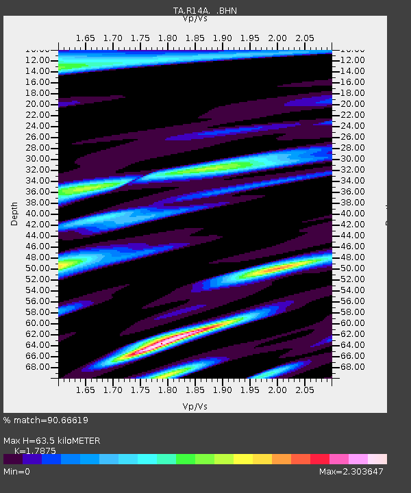
| Estimated Moho Depth: |
63.5 km |
| Estimated Crust Vp/Vs: |
1.79 |
| Assumed Crust Vp: |
6.276 km/s |
| Estimated Crust Vs: |
3.511 km/s |
| Estimated Crust Poisson's Ratio: |
0.27 |
|
| Radial Match: |
90.66619 % |
| Radial Bump: |
400 |
| Transverse Match: |
78.27046 % |
| Transverse Bump: |
400 |
| SOD ConfigId: |
2564 |
| Insert Time: |
2010-03-07 04:15:50.490 +0000 |
| GWidth: |
2.5 |
| Max Bumps: |
400 |
| Tol: |
0.001 |
|
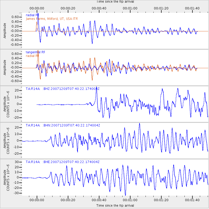
Signal To Noise
| Channel | StoN | STA | LTA |
| TA:R14A: :BHN:20071209T07:40:22.174004Z | 0.87765294 | 2.6472947E-7 | 3.016334E-7 |
| TA:R14A: :BHE:20071209T07:40:22.174004Z | 2.3953235 | 6.4709405E-7 | 2.7014892E-7 |
| TA:R14A: :BHZ:20071209T07:40:22.174004Z | 5.7559705 | 1.2005588E-6 | 2.0857627E-7 |
| Arrivals |
| Ps | 8.1 SECOND |
| PpPs | 28 SECOND |
| PsPs/PpSs | 36 SECOND |


