You are here: Home > Network List > TA - USArray Transportable Network (new EarthScope stations) Stations List
> Station R14A James Farms, Milford, UT, USA > Earthquake Result Viewer
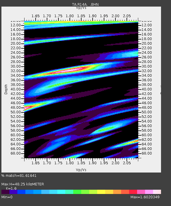
R14A James Farms, Milford, UT, USA - Earthquake Result Viewer
| Earthquake location: |
Volcano Islands, Japan Region |
| Earthquake latitude/longitude: |
22.0/142.7 |
| Earthquake time(UTC): |
2007/09/28 (271) 13:38:59 GMT |
| Earthquake Depth: |
276 km |
| Earthquake Magnitude: |
6.7 MB, 7.4 MW, 7.4 MW |
| Earthquake Catalog/Contributor: |
WHDF/NEIC |
|
| Network: |
TA USArray Transportable Network (new EarthScope stations) |
| Station: |
R14A James Farms, Milford, UT, USA |
| Lat/Lon: |
38.30 N/113.02 W |
| Elevation: |
1542 m |
|
| Distance: |
87.2 deg |
| Az: |
49.753 deg |
| Baz: |
295.809 deg |
| Ray Param: |
0.04283792 |
| Estimated Moho Depth: |
48.25 km |
| Estimated Crust Vp/Vs: |
1.60 |
| Assumed Crust Vp: |
6.276 km/s |
| Estimated Crust Vs: |
3.922 km/s |
| Estimated Crust Poisson's Ratio: |
0.18 |
|
| Radial Match: |
81.61641 % |
| Radial Bump: |
400 |
| Transverse Match: |
83.978775 % |
| Transverse Bump: |
400 |
| SOD ConfigId: |
2564 |
| Insert Time: |
2010-03-07 04:15:57.497 +0000 |
| GWidth: |
2.5 |
| Max Bumps: |
400 |
| Tol: |
0.001 |
|

Signal To Noise
| Channel | StoN | STA | LTA |
| TA:R14A: :BHN:20070928T13:50:43.375012Z | 5.239237 | 2.2161676E-6 | 4.2299436E-7 |
| TA:R14A: :BHE:20070928T13:50:43.375012Z | 11.637224 | 4.8333877E-6 | 4.1533855E-7 |
| TA:R14A: :BHZ:20070928T13:50:43.375012Z | 33.97703 | 1.0663068E-5 | 3.1383163E-7 |
| Arrivals |
| Ps | 4.7 SECOND |
| PpPs | 20 SECOND |
| PsPs/PpSs | 24 SECOND |


