You are here: Home > Network List > TA - USArray Transportable Network (new EarthScope stations) Stations List
> Station R14A James Farms, Milford, UT, USA > Earthquake Result Viewer
R14A James Farms, Milford, UT, USA - Earthquake Result Viewer

| Earthquake location: |
Near West Coast Of Colombia |
| Earthquake latitude/longitude: |
3.0/-78.0 |
| Earthquake time(UTC): |
2007/09/10 (253) 01:49:14 GMT |
| Earthquake Depth: |
31 km |
| Earthquake Magnitude: |
6.1 MB, 6.7 MS, 6.8 MW |
| Earthquake Catalog/Contributor: |
WHDF/NEIC |
|
| Network: |
TA USArray Transportable Network (new EarthScope stations) |
| Station: |
R14A James Farms, Milford, UT, USA |
| Lat/Lon: |
38.30 N/113.02 W |
| Elevation: |
1542 m |
|
| Distance: |
47.5 deg |
| Az: |
322.224 deg |
| Baz: |
128.965 deg |
| Ray Param: |
0.069867924 |
| Estimated Moho Depth: |
35.25 km |
| Estimated Crust Vp/Vs: |
1.78 |
| Assumed Crust Vp: |
6.276 km/s |
| Estimated Crust Vs: |
3.521 km/s |
| Estimated Crust Poisson's Ratio: |
0.27 |
|
| Radial Match: |
85.79379 % |
| Radial Bump: |
400 |
| Transverse Match: |
73.926674 % |
| Transverse Bump: |
400 |
| SOD ConfigId: |
2564 |
| Insert Time: |
2010-03-07 04:15:58.929 +0000 |
| GWidth: |
2.5 |
| Max Bumps: |
400 |
| Tol: |
0.001 |
|
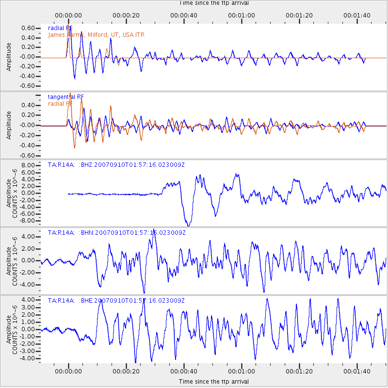
Signal To Noise
| Channel | StoN | STA | LTA |
| TA:R14A: :BHN:20070910T01:57:16.023009Z | 4.431618 | 7.856963E-7 | 1.7729332E-7 |
| TA:R14A: :BHE:20070910T01:57:16.023009Z | 3.2303164 | 6.5272667E-7 | 2.0206276E-7 |
| TA:R14A: :BHZ:20070910T01:57:16.023009Z | 15.143575 | 1.436092E-6 | 9.4831776E-8 |
| Arrivals |
| Ps | 4.7 SECOND |
| PpPs | 15 SECOND |
| PsPs/PpSs | 19 SECOND |


