You are here: Home > Network List > TA - USArray Transportable Network (new EarthScope stations) Stations List
> Station R14A James Farms, Milford, UT, USA > Earthquake Result Viewer
R14A James Farms, Milford, UT, USA - Earthquake Result Viewer

| Earthquake location: |
Near Coast Of Peru |
| Earthquake latitude/longitude: |
-13.6/-76.6 |
| Earthquake time(UTC): |
2007/08/17 (229) 13:18:13 GMT |
| Earthquake Depth: |
48 km |
| Earthquake Magnitude: |
5.6 MB, 5.6 MS, 5.9 MW |
| Earthquake Catalog/Contributor: |
WHDF/NEIC |
|
| Network: |
TA USArray Transportable Network (new EarthScope stations) |
| Station: |
R14A James Farms, Milford, UT, USA |
| Lat/Lon: |
38.30 N/113.02 W |
| Elevation: |
1542 m |
|
| Distance: |
61.9 deg |
| Az: |
328.017 deg |
| Baz: |
139.116 deg |
| Ray Param: |
0.060489494 |
| Estimated Moho Depth: |
41.0 km |
| Estimated Crust Vp/Vs: |
1.60 |
| Assumed Crust Vp: |
6.276 km/s |
| Estimated Crust Vs: |
3.922 km/s |
| Estimated Crust Poisson's Ratio: |
0.18 |
|
| Radial Match: |
80.47281 % |
| Radial Bump: |
400 |
| Transverse Match: |
79.792336 % |
| Transverse Bump: |
400 |
| SOD ConfigId: |
2564 |
| Insert Time: |
2010-03-07 04:16:01.717 +0000 |
| GWidth: |
2.5 |
| Max Bumps: |
400 |
| Tol: |
0.001 |
|
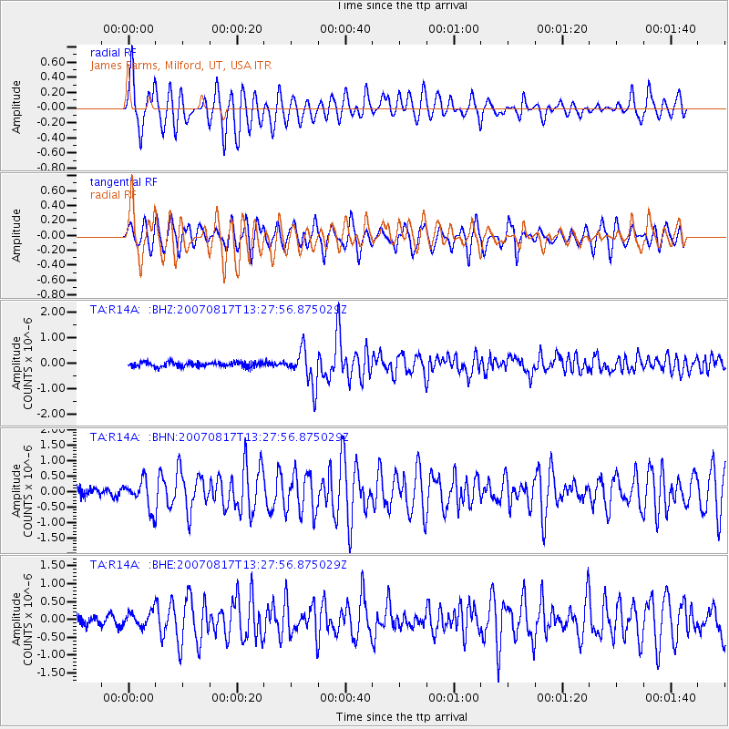
Signal To Noise
| Channel | StoN | STA | LTA |
| TA:R14A: :BHN:20070817T13:27:56.875029Z | 4.1562214 | 4.6867652E-7 | 1.1276505E-7 |
| TA:R14A: :BHE:20070817T13:27:56.875029Z | 1.9365747 | 2.0797586E-7 | 1.0739367E-7 |
| TA:R14A: :BHZ:20070817T13:27:56.875029Z | 7.628976 | 7.076571E-7 | 9.2759116E-8 |
| Arrivals |
| Ps | 4.1 SECOND |
| PpPs | 16 SECOND |
| PsPs/PpSs | 20 SECOND |


