You are here: Home > Network List > TA - USArray Transportable Network (new EarthScope stations) Stations List
> Station R14A James Farms, Milford, UT, USA > Earthquake Result Viewer
R14A James Farms, Milford, UT, USA - Earthquake Result Viewer
| Earthquake location: |
Near Coast Of Peru |
| Earthquake latitude/longitude: |
-13.4/-76.6 |
| Earthquake time(UTC): |
2007/08/15 (227) 23:40:57 GMT |
| Earthquake Depth: |
39 km |
| Earthquake Magnitude: |
6.7 MB, 7.9 MS, 8.0 MW, 7.5 ME |
| Earthquake Catalog/Contributor: |
WHDF/NEIC |
|
| Network: |
TA USArray Transportable Network (new EarthScope stations) |
| Station: |
R14A James Farms, Milford, UT, USA |
| Lat/Lon: |
38.30 N/113.02 W |
| Elevation: |
1542 m |
|
| Distance: |
61.7 deg |
| Az: |
327.957 deg |
| Baz: |
138.988 deg |
| Ray Param: |
0.06063975 |
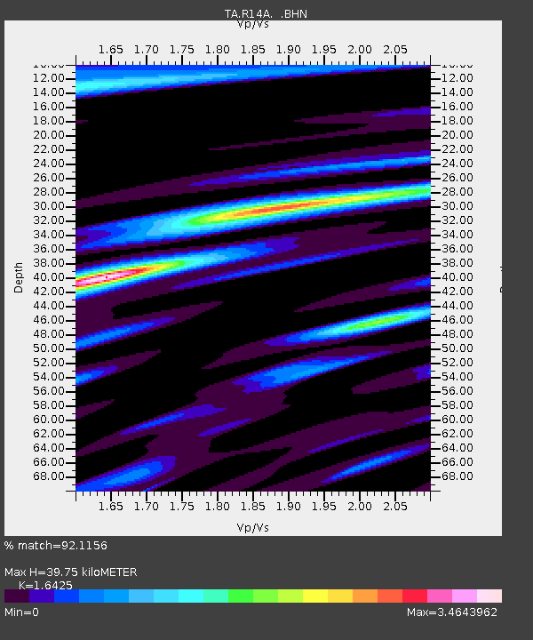
| Estimated Moho Depth: |
39.75 km |
| Estimated Crust Vp/Vs: |
1.64 |
| Assumed Crust Vp: |
6.276 km/s |
| Estimated Crust Vs: |
3.821 km/s |
| Estimated Crust Poisson's Ratio: |
0.21 |
|
| Radial Match: |
92.1156 % |
| Radial Bump: |
400 |
| Transverse Match: |
84.09477 % |
| Transverse Bump: |
400 |
| SOD ConfigId: |
2564 |
| Insert Time: |
2010-03-07 04:16:05.962 +0000 |
| GWidth: |
2.5 |
| Max Bumps: |
400 |
| Tol: |
0.001 |
|

Signal To Noise
| Channel | StoN | STA | LTA |
| TA:R14A: :BHN:20070815T23:50:41.29802Z | 9.813759 | 1.180659E-6 | 1.2030648E-7 |
| TA:R14A: :BHE:20070815T23:50:41.29802Z | 6.272037 | 9.247251E-7 | 1.4743617E-7 |
| TA:R14A: :BHZ:20070815T23:50:41.29802Z | 22.254366 | 2.4597364E-6 | 1.1052826E-7 |
| Arrivals |
| Ps | 4.3 SECOND |
| PpPs | 16 SECOND |
| PsPs/PpSs | 20 SECOND |


