You are here: Home > Network List > TA - USArray Transportable Network (new EarthScope stations) Stations List
> Station K11A Parker Ranch, Bruneau, ID, USA > Earthquake Result Viewer
K11A Parker Ranch, Bruneau, ID, USA - Earthquake Result Viewer
| Earthquake location: |
Kuril Islands |
| Earthquake latitude/longitude: |
46.4/153.2 |
| Earthquake time(UTC): |
2008/03/03 (063) 09:31:02 GMT |
| Earthquake Depth: |
10 km |
| Earthquake Magnitude: |
6.2 MB, 6.5 MS, 6.5 MW, 6.5 MW |
| Earthquake Catalog/Contributor: |
WHDF/NEIC |
|
| Network: |
TA USArray Transportable Network (new EarthScope stations) |
| Station: |
K11A Parker Ranch, Bruneau, ID, USA |
| Lat/Lon: |
42.77 N/116.03 W |
| Elevation: |
914 m |
|
| Distance: |
61.2 deg |
| Az: |
57.142 deg |
| Baz: |
307.87 deg |
| Ray Param: |
0.061013985 |
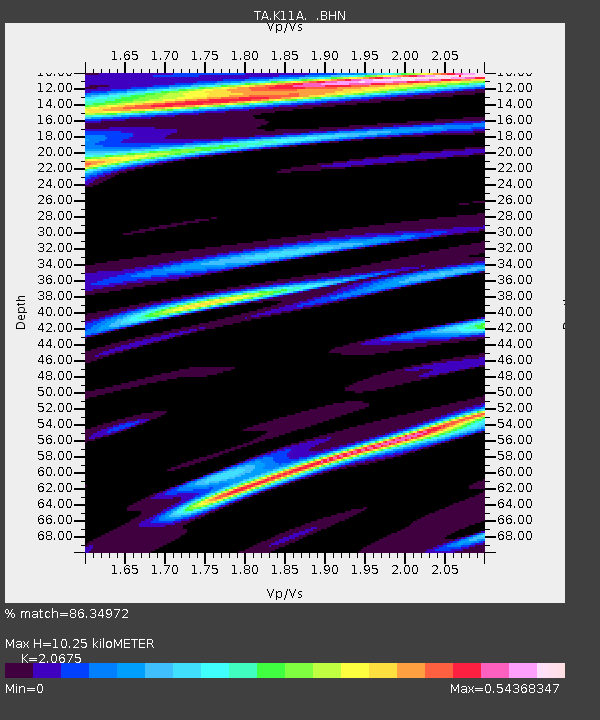
| Estimated Moho Depth: |
10.25 km |
| Estimated Crust Vp/Vs: |
2.07 |
| Assumed Crust Vp: |
6.291 km/s |
| Estimated Crust Vs: |
3.043 km/s |
| Estimated Crust Poisson's Ratio: |
0.35 |
|
| Radial Match: |
86.34972 % |
| Radial Bump: |
400 |
| Transverse Match: |
64.25176 % |
| Transverse Bump: |
400 |
| SOD ConfigId: |
2564 |
| Insert Time: |
2010-03-07 04:21:10.792 +0000 |
| GWidth: |
2.5 |
| Max Bumps: |
400 |
| Tol: |
0.001 |
|
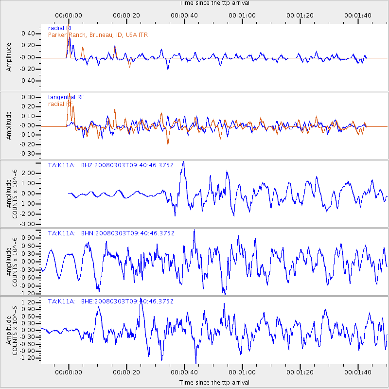
Signal To Noise
| Channel | StoN | STA | LTA |
| TA:K11A: :BHN:20080303T09:40:46.375Z | 1.7615042 | 3.6358406E-7 | 2.0640546E-7 |
| TA:K11A: :BHE:20080303T09:40:46.375Z | 1.0055369 | 1.3016076E-7 | 1.2944403E-7 |
| TA:K11A: :BHZ:20080303T09:40:46.375Z | 1.6208605 | 3.0764846E-7 | 1.8980563E-7 |
| Arrivals |
| Ps | 1.8 SECOND |
| PpPs | 4.8 SECOND |
| PsPs/PpSs | 6.6 SECOND |


