
Station TA K11A - Parker Ranch, Bruneau, ID, USA
Network: TA - USArray Transportable Network (new EarthScope stations)
Nearby stations (2 deg radius)
| Station | Name | (Lat, Lon) | Start / End | Elevation |
| K11A | Parker Ranch, Bruneau, ID, USA | (42.77, -116.03) | 2007-02-06 / 2499-01-01 | 0.9 km |
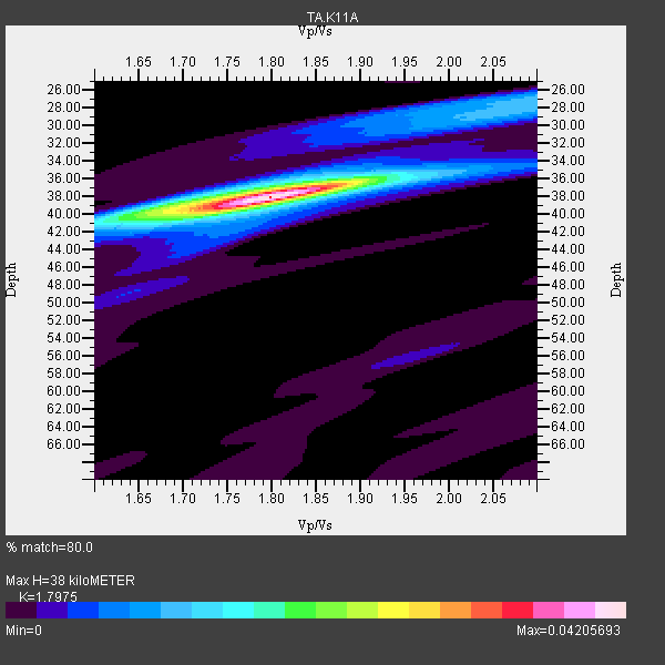
| Crust2 Type: | M9,thick extended crust, 0.5 km seds. |
| Thickness Estimate: | 38 km |
| Thickness StdDev: | 0.2 km |
| Vp/Vs Estimate: | 1.80 |
| Vp/Vs StdDev: | 0.01 |
| Vs Estimate: | 3.5 km/s |
| Poisson's Ratio: | 0.28 |
| Peak Value: | 0.04 |
| Assumed Vp: | 6.291 km/s |
| Ps Weight: | 0.33333334 |
| PpPs Weight: | 0.33333334 |
| PsPs Weight: | 0.33333328 |
| Residual Complexity: | 0.384 |
| Nearby stations H: | +- |
| (2.0 deg) Vp/Vs: | +- |
17 with match > 90% ( 51.515152 %) and 33 with match > 80% ( 100.0 %) out of 33.
Download stack as xyz text file.
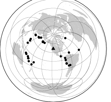
Azimuth Distribution of Events:
Prior Results for this Station
| Study | Thickness | Vp/Vs | Vp | Vs | Poissons Ratio | Extra |
| EARS | 38 km | 1.80 | 6.291 km/s | 3.5 km/s | 0.28 | |
| Crust2.0 | 40 km | 1.78 | 6.291 km/s | 3.539 km/s | 0.27 | M9,thick extended crust, 0.5 km seds. |
| Global Maxima | 38 km | 1.80 | 6.291 km/s | 3.5 km/s | 0.28 | amp=0.04205693 |
| Local Maxima 1 | 39 km | 1.69 | 6.291 km/s | 3.734 km/s | 0.23 | amp=0.013240105 |
| Local Maxima 2 | 28 km | 2.08 | 6.291 km/s | 3.032 km/s | 0.35 | amp=0.010990242 |
| Local Maxima 3 | 26 km | 2.10 | 6.291 km/s | 2.999 km/s | 0.35 | amp=0.0065212613 |
| Local Maxima 4 | 40 km | 1.67 | 6.291 km/s | 3.773 km/s | 0.22 | amp=0.0044305297 |
| Predicted Arrivals for vertical incidence (zero ray parameter) | |
| Ps | 4.82 SECOND |
| PpPs | 16.90 SECOND |
| PsPs/PpSs | 21.71 SECOND |
Events Processed for this Station
Download zip of receiver functions as SAC
Plot maxima for each earthquake.
Events Used in the Stack
(33 events)| Radial Match | Distance | Baz | FERegion | Time | Lat/Lon | Depth | Magnitude |
| 98.63894 | 89.3 deg | 253.575 deg | Santa Cruz Islands | 2007/09/02 01:05:18 GMT | (-11.6, 165.8) | 35 km | 5.9 MB, 7.3 MS, 7.2 MW, 6.9 ME |
| 98.35162 | 66.6 deg | 137.646 deg | Near Coast Of Peru | 2007/08/15 23:40:57 GMT | (-13.4, -76.6) | 39 km | 6.7 MB, 7.9 MS, 8.0 MW, 7.5 ME |
| 98.096436 | 77.4 deg | 136.805 deg | Northern Chile | 2007/11/14 15:40:50 GMT | (-22.2, -69.9) | 40 km | 6.7 MB, 7.4 MS, 7.7 MW, 7.4 ME |
| 95.92984 | 56.6 deg | 132.232 deg | Peru-Ecuador Border Region | 2007/11/16 03:13:00 GMT | (-2.3, -77.8) | 123 km | 6.3 MB, 6.8 MW, 6.7 MW |
| 95.6059 | 93.4 deg | 261.732 deg | Solomon Islands | 2007/04/01 20:39:56 GMT | (-8.5, 157.0) | 10 km | 6.8 MB, 7.9 MS, 8.1 MW, 7.7 ME |
| 94.9831 | 90.7 deg | 249.433 deg | Vanuatu Islands | 2007/08/01 17:08:51 GMT | (-15.6, 167.7) | 120 km | 6.2 MB, 7.2 MW, 7.2 MW |
| 94.97095 | 92.6 deg | 259.106 deg | Solomon Islands | 2007/08/16 08:39:27 GMT | (-9.8, 159.5) | 10 km | 6.1 MB, 6.7 MS, 6.4 MW |
| 94.501915 | 83.2 deg | 293.597 deg | Volcano Islands, Japan Region | 2007/09/28 13:38:59 GMT | (22.0, 142.7) | 276 km | 6.7 MB, 7.4 MW, 7.4 MW |
| 94.175835 | 54.2 deg | 103.407 deg | Windward Islands | 2007/11/29 19:00:19 GMT | (15.0, -61.3) | 148 km | 6.9 MB, 7.4 MW, 7.4 MW |
| 94.15193 | 79.5 deg | 133.527 deg | Jujuy Province, Argentina | 2007/07/21 15:34:52 GMT | (-22.2, -65.8) | 290 km | 5.8 MB, 6.4 MW, 6.3 MW |
| 93.77682 | 42.8 deg | 304.412 deg | Andreanof Islands, Aleutian Is. | 2007/12/19 09:30:27 GMT | (51.4, -179.5) | 29 km | 6.4 MB, 7.1 MS, 7.1 MW, 7.0 MW |
| 93.710724 | 41.9 deg | 302.455 deg | Andreanof Islands, Aleutian Is. | 2007/08/15 20:22:11 GMT | (50.3, -177.5) | 9.0 km | 6.3 MB, 6.2 MS, 6.4 MW, 5.9 ML |
| 92.899734 | 35.7 deg | 304.22 deg | Fox Islands, Aleutian Islands | 2007/07/15 13:08:00 GMT | (52.5, -168.0) | 10 km | 5.8 MB, 5.9 MS, 6.1 MW, 6.0 MW |
| 92.75349 | 89.0 deg | 283.195 deg | South Of Mariana Islands | 2007/09/30 02:08:30 GMT | (10.5, 145.7) | 14 km | 6.4 MB, 7.1 MS, 6.9 MW, 6.9 MW |
| 91.479485 | 83.5 deg | 289.575 deg | Mariana Islands | 2007/10/31 03:30:17 GMT | (18.9, 145.4) | 223 km | 6.2 MB, 7.2 MW, 7.2 MW |
| 90.7278 | 66.8 deg | 137.791 deg | Near Coast Of Peru | 2007/08/19 01:22:40 GMT | (-13.6, -76.6) | 26 km | 5.9 MB, 5.4 MS, 5.8 MW, 5.5 ML |
| 90.65039 | 50.5 deg | 128.115 deg | South Of Panama | 2007/03/18 02:11:05 GMT | (4.6, -78.5) | 8.0 km | 6.4 MB, 5.7 MS, 6.2 MW, 6.1 MW |
| 89.795906 | 89.9 deg | 248.964 deg | Vanuatu Islands | 2007/07/15 09:27:34 GMT | (-15.4, 168.6) | 8.0 km | 6.0 MB, 5.8 MS, 6.1 MW, 6.0 MW |
| 88.97525 | 56.0 deg | 312.084 deg | Kamchatka Peninsula, Russia | 2007/05/30 20:22:12 GMT | (52.1, 157.3) | 116 km | 6.4 MB, 6.4 MW, 6.4 MW |
| 88.03837 | 90.4 deg | 234.43 deg | South Of Fiji Islands | 2007/10/16 21:05:43 GMT | (-25.8, 179.5) | 509 km | 6.2 MB, 6.6 MW, 6.5 MW |
| 86.34972 | 61.2 deg | 307.87 deg | Kuril Islands | 2008/03/03 09:31:02 GMT | (46.4, 153.2) | 10 km | 6.2 MB, 6.5 MS, 6.5 MW, 6.5 MW |
| 86.114494 | 66.7 deg | 137.764 deg | Near Coast Of Peru | 2007/08/17 13:18:13 GMT | (-13.6, -76.6) | 48 km | 5.6 MB, 5.6 MS, 5.9 MW |
| 85.4513 | 75.3 deg | 307.637 deg | Near West Coast Of Honshu, Japan | 2007/07/16 01:13:22 GMT | (37.5, 138.4) | 12 km | 6.5 MB, 6.4 MS, 6.6 MW, 6.5 MW |
| 85.450806 | 76.5 deg | 308.533 deg | Near West Coast Of Honshu, Japan | 2007/03/25 00:41:57 GMT | (37.3, 136.6) | 8.0 km | 6.1 MB, 6.8 MS, 6.7 MW, 6.6 MW |
| 85.3331 | 86.4 deg | 92.348 deg | Central Mid-Atlantic Ridge | 2007/07/03 08:26:00 GMT | (0.7, -30.3) | 10 km | 5.8 MB, 5.9 MS, 6.3 MW, 6.1 MW |
| 85.09307 | 54.6 deg | 48.509 deg | Northern Mid-Atlantic Ridge | 2007/05/23 04:41:46 GMT | (52.4, -31.8) | 10 km | 5.6 MS, 5.4 MB, 5.7 MW, 5.6 MW |
| 84.413635 | 67.6 deg | 137.708 deg | Near Coast Of Peru | 2007/08/16 05:16:56 GMT | (-14.3, -76.1) | 23 km | 5.8 MB, 6.1 MS, 6.3 MW, 6.2 ML |
| 83.62796 | 36.1 deg | 135.329 deg | Near Coast Of Guatemala | 2007/06/08 13:32:00 GMT | (13.8, -90.8) | 48 km | 5.5 MB, 5.4 MS, 5.8 MW, 5.8 MW |
| 83.49596 | 63.3 deg | 308.696 deg | Kuril Islands | 2007/09/03 16:14:53 GMT | (45.8, 150.1) | 94 km | 6.3 MB, 6.2 MW, 6.2 ME |
| 83.08007 | 80.4 deg | 235.465 deg | Tonga Islands | 2007/08/26 12:37:31 GMT | (-17.5, -174.3) | 127 km | 5.9 MB, 6.1 MW |
| 81.817184 | 42.2 deg | 305.409 deg | Andreanof Islands, Aleutian Is. | 2008/03/22 21:24:11 GMT | (52.2, -178.7) | 132 km | 5.8 MB, 6.2 MW, 6.1 MW |
| 81.74036 | 92.6 deg | 243.111 deg | Southeast Of Loyalty Islands | 2007/07/27 14:46:26 GMT | (-21.5, 170.9) | 10 km | 6.0 MB, 6.0 MS, 6.1 MW, 6.1 MW |
| 81.57826 | 43.1 deg | 304.436 deg | Andreanof Islands, Aleutian Is. | 2007/08/02 03:21:42 GMT | (51.3, -180.0) | 21 km | 6.3 MB, 6.6 MS, 6.7 MW, 6.6 MW |
Losers
(0 events)| Radial Match | Distance | Baz | FERegion | Time | Lat/Lon | Depth | Magnitude | Reason |
