You are here: Home > Network List > TA - USArray Transportable Network (new EarthScope stations) Stations List
> Station K11A Parker Ranch, Bruneau, ID, USA > Earthquake Result Viewer
K11A Parker Ranch, Bruneau, ID, USA - Earthquake Result Viewer
| Earthquake location: |
South Of Mariana Islands |
| Earthquake latitude/longitude: |
10.5/145.7 |
| Earthquake time(UTC): |
2007/09/30 (273) 02:08:30 GMT |
| Earthquake Depth: |
14 km |
| Earthquake Magnitude: |
6.4 MB, 7.1 MS, 6.9 MW, 6.9 MW |
| Earthquake Catalog/Contributor: |
WHDF/NEIC |
|
| Network: |
TA USArray Transportable Network (new EarthScope stations) |
| Station: |
K11A Parker Ranch, Bruneau, ID, USA |
| Lat/Lon: |
42.77 N/116.03 W |
| Elevation: |
914 m |
|
| Distance: |
89.0 deg |
| Az: |
46.789 deg |
| Baz: |
283.195 deg |
| Ray Param: |
0.042187694 |
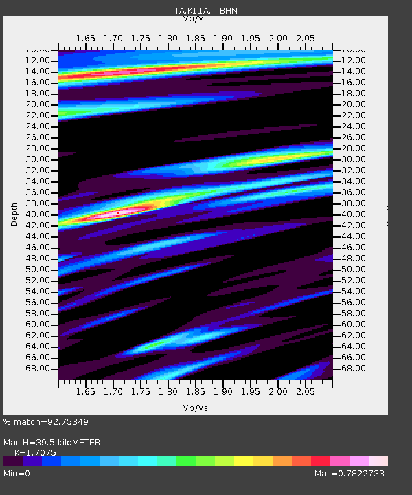
| Estimated Moho Depth: |
39.5 km |
| Estimated Crust Vp/Vs: |
1.71 |
| Assumed Crust Vp: |
6.291 km/s |
| Estimated Crust Vs: |
3.684 km/s |
| Estimated Crust Poisson's Ratio: |
0.24 |
|
| Radial Match: |
92.75349 % |
| Radial Bump: |
400 |
| Transverse Match: |
86.04805 % |
| Transverse Bump: |
400 |
| SOD ConfigId: |
2564 |
| Insert Time: |
2010-03-07 04:21:23.856 +0000 |
| GWidth: |
2.5 |
| Max Bumps: |
400 |
| Tol: |
0.001 |
|

Signal To Noise
| Channel | StoN | STA | LTA |
| TA:K11A: :BHN:20070930T02:20:52.700029Z | 1.2995274 | 1.253522E-7 | 9.6459836E-8 |
| TA:K11A: :BHE:20070930T02:20:52.700029Z | 1.4314425 | 1.8944372E-7 | 1.3234462E-7 |
| TA:K11A: :BHZ:20070930T02:20:52.700029Z | 5.198566 | 7.838009E-7 | 1.5077252E-7 |
| Arrivals |
| Ps | 4.5 SECOND |
| PpPs | 17 SECOND |
| PsPs/PpSs | 21 SECOND |


