You are here: Home > Network List > TA - USArray Transportable Network (new EarthScope stations) Stations List
> Station K11A Parker Ranch, Bruneau, ID, USA > Earthquake Result Viewer
K11A Parker Ranch, Bruneau, ID, USA - Earthquake Result Viewer
| Earthquake location: |
Kuril Islands |
| Earthquake latitude/longitude: |
45.8/150.1 |
| Earthquake time(UTC): |
2007/09/03 (246) 16:14:53 GMT |
| Earthquake Depth: |
94 km |
| Earthquake Magnitude: |
6.3 MB, 6.2 MW, 6.2 ME |
| Earthquake Catalog/Contributor: |
WHDF/NEIC |
|
| Network: |
TA USArray Transportable Network (new EarthScope stations) |
| Station: |
K11A Parker Ranch, Bruneau, ID, USA |
| Lat/Lon: |
42.77 N/116.03 W |
| Elevation: |
914 m |
|
| Distance: |
63.3 deg |
| Az: |
55.288 deg |
| Baz: |
308.696 deg |
| Ray Param: |
0.059390575 |
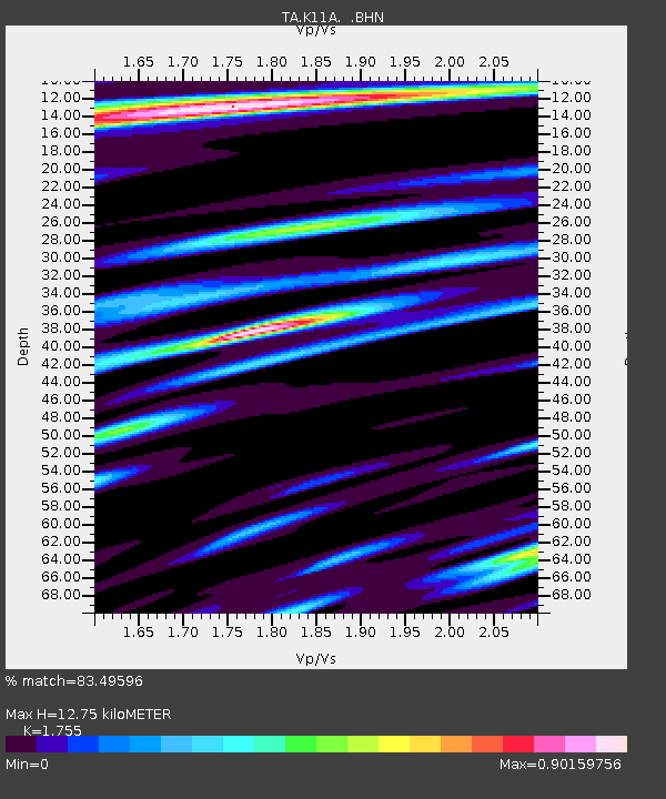
| Estimated Moho Depth: |
12.75 km |
| Estimated Crust Vp/Vs: |
1.75 |
| Assumed Crust Vp: |
6.291 km/s |
| Estimated Crust Vs: |
3.585 km/s |
| Estimated Crust Poisson's Ratio: |
0.26 |
|
| Radial Match: |
83.49596 % |
| Radial Bump: |
400 |
| Transverse Match: |
75.931046 % |
| Transverse Bump: |
400 |
| SOD ConfigId: |
2564 |
| Insert Time: |
2010-03-07 04:21:26.709 +0000 |
| GWidth: |
2.5 |
| Max Bumps: |
400 |
| Tol: |
0.001 |
|
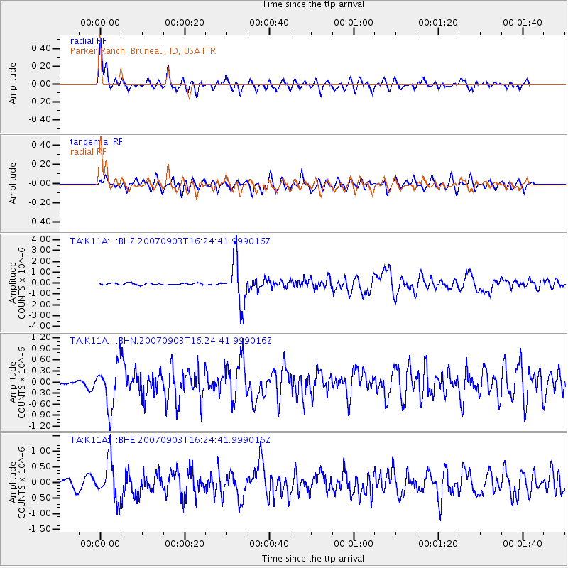
Signal To Noise
| Channel | StoN | STA | LTA |
| TA:K11A: :BHN:20070903T16:24:41.999016Z | 6.0077186 | 5.9365874E-7 | 9.8816E-8 |
| TA:K11A: :BHE:20070903T16:24:41.999016Z | 5.8215747 | 6.473102E-7 | 1.1119159E-7 |
| TA:K11A: :BHZ:20070903T16:24:41.999016Z | 26.049751 | 2.1160852E-6 | 8.123244E-8 |
| Arrivals |
| Ps | 1.6 SECOND |
| PpPs | 5.4 SECOND |
| PsPs/PpSs | 7.0 SECOND |


