You are here: Home > Network List > TA - USArray Transportable Network (new EarthScope stations) Stations List
> Station K11A Parker Ranch, Bruneau, ID, USA > Earthquake Result Viewer
K11A Parker Ranch, Bruneau, ID, USA - Earthquake Result Viewer
| Earthquake location: |
Tonga Islands |
| Earthquake latitude/longitude: |
-17.5/-174.3 |
| Earthquake time(UTC): |
2007/08/26 (238) 12:37:31 GMT |
| Earthquake Depth: |
127 km |
| Earthquake Magnitude: |
5.9 MB, 6.1 MW |
| Earthquake Catalog/Contributor: |
WHDF/NEIC |
|
| Network: |
TA USArray Transportable Network (new EarthScope stations) |
| Station: |
K11A Parker Ranch, Bruneau, ID, USA |
| Lat/Lon: |
42.77 N/116.03 W |
| Elevation: |
914 m |
|
| Distance: |
80.4 deg |
| Az: |
39.456 deg |
| Baz: |
235.465 deg |
| Ray Param: |
0.04804246 |
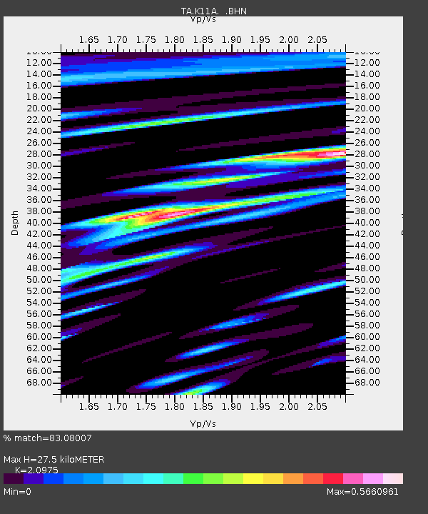
| Estimated Moho Depth: |
27.5 km |
| Estimated Crust Vp/Vs: |
2.10 |
| Assumed Crust Vp: |
6.291 km/s |
| Estimated Crust Vs: |
2.999 km/s |
| Estimated Crust Poisson's Ratio: |
0.35 |
|
| Radial Match: |
83.08007 % |
| Radial Bump: |
400 |
| Transverse Match: |
67.74637 % |
| Transverse Bump: |
380 |
| SOD ConfigId: |
2564 |
| Insert Time: |
2010-03-07 04:21:30.110 +0000 |
| GWidth: |
2.5 |
| Max Bumps: |
400 |
| Tol: |
0.001 |
|

Signal To Noise
| Channel | StoN | STA | LTA |
| TA:K11A: :BHN:20070826T12:48:57.249021Z | 1.578197 | 1.343611E-7 | 8.513583E-8 |
| TA:K11A: :BHE:20070826T12:48:57.249021Z | 3.283359 | 2.4255323E-7 | 7.38735E-8 |
| TA:K11A: :BHZ:20070826T12:48:57.249021Z | 11.122717 | 9.042395E-7 | 8.129664E-8 |
| Arrivals |
| Ps | 4.9 SECOND |
| PpPs | 13 SECOND |
| PsPs/PpSs | 18 SECOND |


