You are here: Home > Network List > TA - USArray Transportable Network (new EarthScope stations) Stations List
> Station K11A Parker Ranch, Bruneau, ID, USA > Earthquake Result Viewer
K11A Parker Ranch, Bruneau, ID, USA - Earthquake Result Viewer
| Earthquake location: |
Southeast Of Loyalty Islands |
| Earthquake latitude/longitude: |
-21.5/170.9 |
| Earthquake time(UTC): |
2007/07/27 (208) 14:46:26 GMT |
| Earthquake Depth: |
10 km |
| Earthquake Magnitude: |
6.0 MB, 6.0 MS, 6.1 MW, 6.1 MW |
| Earthquake Catalog/Contributor: |
WHDF/NEIC |
|
| Network: |
TA USArray Transportable Network (new EarthScope stations) |
| Station: |
K11A Parker Ranch, Bruneau, ID, USA |
| Lat/Lon: |
42.77 N/116.03 W |
| Elevation: |
914 m |
|
| Distance: |
92.6 deg |
| Az: |
44.831 deg |
| Baz: |
243.111 deg |
| Ray Param: |
0.04142058 |
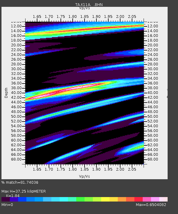
| Estimated Moho Depth: |
37.25 km |
| Estimated Crust Vp/Vs: |
1.84 |
| Assumed Crust Vp: |
6.291 km/s |
| Estimated Crust Vs: |
3.419 km/s |
| Estimated Crust Poisson's Ratio: |
0.29 |
|
| Radial Match: |
81.74036 % |
| Radial Bump: |
400 |
| Transverse Match: |
68.00697 % |
| Transverse Bump: |
400 |
| SOD ConfigId: |
2564 |
| Insert Time: |
2010-03-07 04:21:46.039 +0000 |
| GWidth: |
2.5 |
| Max Bumps: |
400 |
| Tol: |
0.001 |
|
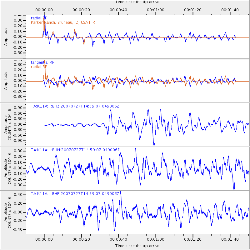
Signal To Noise
| Channel | StoN | STA | LTA |
| TA:K11A: :BHN:20070727T14:59:07.049006Z | 0.9185825 | 6.0954264E-8 | 6.6356876E-8 |
| TA:K11A: :BHE:20070727T14:59:07.049006Z | 0.49696362 | 2.6833362E-8 | 5.3994622E-8 |
| TA:K11A: :BHZ:20070727T14:59:07.049006Z | 4.4521685 | 1.8256357E-7 | 4.1005542E-8 |
| Arrivals |
| Ps | 5.1 SECOND |
| PpPs | 17 SECOND |
| PsPs/PpSs | 22 SECOND |


