You are here: Home > Network List > TA - USArray Transportable Network (new EarthScope stations) Stations List
> Station K11A Parker Ranch, Bruneau, ID, USA > Earthquake Result Viewer
K11A Parker Ranch, Bruneau, ID, USA - Earthquake Result Viewer
| Earthquake location: |
Fox Islands, Aleutian Islands |
| Earthquake latitude/longitude: |
52.5/-168.0 |
| Earthquake time(UTC): |
2007/07/15 (196) 13:08:00 GMT |
| Earthquake Depth: |
10 km |
| Earthquake Magnitude: |
5.8 MB, 5.9 MS, 6.1 MW, 6.0 MW |
| Earthquake Catalog/Contributor: |
WHDF/NEIC |
|
| Network: |
TA USArray Transportable Network (new EarthScope stations) |
| Station: |
K11A Parker Ranch, Bruneau, ID, USA |
| Lat/Lon: |
42.77 N/116.03 W |
| Elevation: |
914 m |
|
| Distance: |
35.7 deg |
| Az: |
84.557 deg |
| Baz: |
304.22 deg |
| Ray Param: |
0.07710331 |
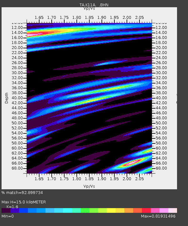
| Estimated Moho Depth: |
15.0 km |
| Estimated Crust Vp/Vs: |
1.60 |
| Assumed Crust Vp: |
6.291 km/s |
| Estimated Crust Vs: |
3.932 km/s |
| Estimated Crust Poisson's Ratio: |
0.18 |
|
| Radial Match: |
92.899734 % |
| Radial Bump: |
296 |
| Transverse Match: |
73.47871 % |
| Transverse Bump: |
400 |
| SOD ConfigId: |
2564 |
| Insert Time: |
2010-03-07 04:21:51.921 +0000 |
| GWidth: |
2.5 |
| Max Bumps: |
400 |
| Tol: |
0.001 |
|
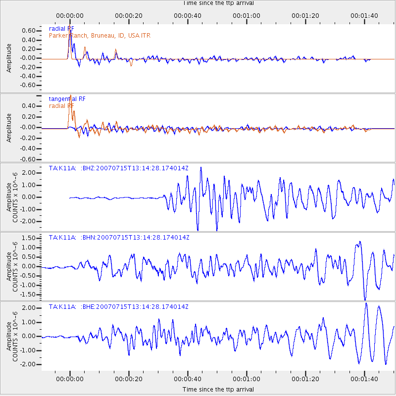
Signal To Noise
| Channel | StoN | STA | LTA |
| TA:K11A: :BHN:20070715T13:14:28.174014Z | 1.5775284 | 9.942791E-8 | 6.302765E-8 |
| TA:K11A: :BHE:20070715T13:14:28.174014Z | 2.0246277 | 1.00244E-7 | 4.9512312E-8 |
| TA:K11A: :BHZ:20070715T13:14:28.174014Z | 7.241497 | 3.2520026E-7 | 4.490788E-8 |
| Arrivals |
| Ps | 1.6 SECOND |
| PpPs | 5.7 SECOND |
| PsPs/PpSs | 7.3 SECOND |


