You are here: Home > Network List > TA - USArray Transportable Network (new EarthScope stations) Stations List
> Station K10A MacKenzie Ranch, Jordan Valley, OR, USA > Earthquake Result Viewer
K10A MacKenzie Ranch, Jordan Valley, OR, USA - Earthquake Result Viewer
| Earthquake location: |
South Of Fiji Islands |
| Earthquake latitude/longitude: |
-26.0/-177.5 |
| Earthquake time(UTC): |
2007/12/09 (343) 07:28:20 GMT |
| Earthquake Depth: |
152 km |
| Earthquake Magnitude: |
7.0 MB, 7.8 MW, 7.7 MW |
| Earthquake Catalog/Contributor: |
WHDF/NEIC |
|
| Network: |
TA USArray Transportable Network (new EarthScope stations) |
| Station: |
K10A MacKenzie Ranch, Jordan Valley, OR, USA |
| Lat/Lon: |
42.78 N/116.87 W |
| Elevation: |
1701 m |
|
| Distance: |
88.3 deg |
| Az: |
39.941 deg |
| Baz: |
231.698 deg |
| Ray Param: |
0.042355724 |
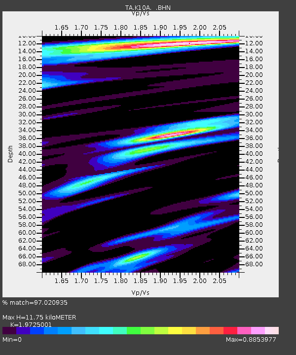
| Estimated Moho Depth: |
11.75 km |
| Estimated Crust Vp/Vs: |
1.97 |
| Assumed Crust Vp: |
6.291 km/s |
| Estimated Crust Vs: |
3.189 km/s |
| Estimated Crust Poisson's Ratio: |
0.33 |
|
| Radial Match: |
97.020935 % |
| Radial Bump: |
325 |
| Transverse Match: |
89.471756 % |
| Transverse Bump: |
400 |
| SOD ConfigId: |
2564 |
| Insert Time: |
2010-03-07 04:22:16.358 +0000 |
| GWidth: |
2.5 |
| Max Bumps: |
400 |
| Tol: |
0.001 |
|
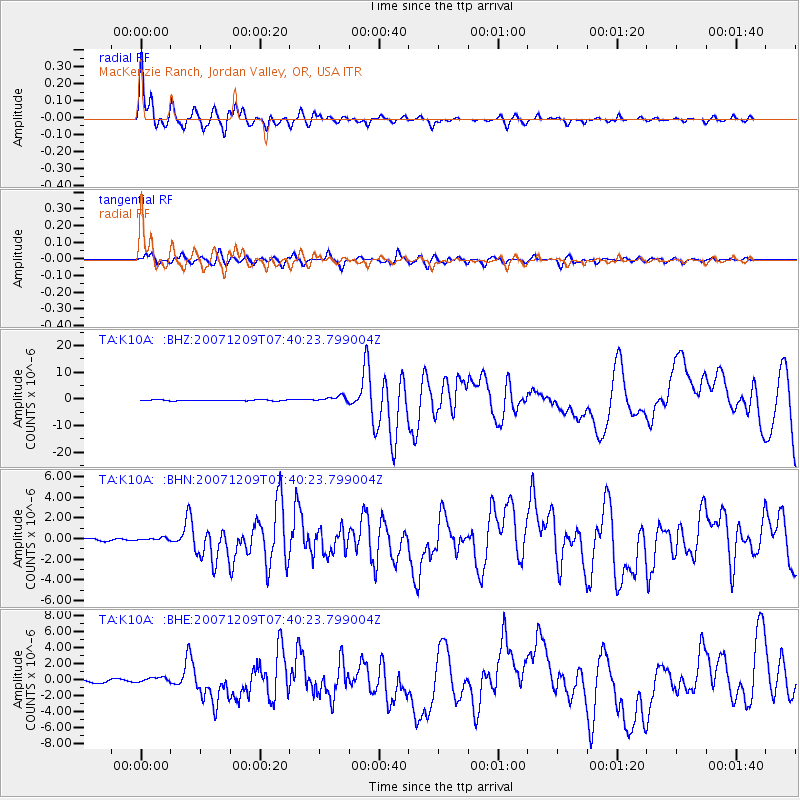
Signal To Noise
| Channel | StoN | STA | LTA |
| TA:K10A: :BHN:20071209T07:40:23.799004Z | 1.0384798 | 1.4640273E-7 | 1.4097792E-7 |
| TA:K10A: :BHE:20071209T07:40:23.799004Z | 3.6384647 | 3.9957118E-7 | 1.0981862E-7 |
| TA:K10A: :BHZ:20071209T07:40:23.799004Z | 6.2557664 | 1.1127395E-6 | 1.778742E-7 |
| Arrivals |
| Ps | 1.9 SECOND |
| PpPs | 5.5 SECOND |
| PsPs/PpSs | 7.3 SECOND |


