
Station TA K10A - MacKenzie Ranch, Jordan Valley, OR, USA
Network: TA - USArray Transportable Network (new EarthScope stations)
Nearby stations (2 deg radius)
| Station | Name | (Lat, Lon) | Start / End | Elevation |
| K10A | MacKenzie Ranch, Jordan Valley, OR, USA | (42.78, -116.87) | 2006-12-16 / 2499-01-01 | 1.7 km |
| Crust2 Type: | M9,thick extended crust, 0.5 km seds. |
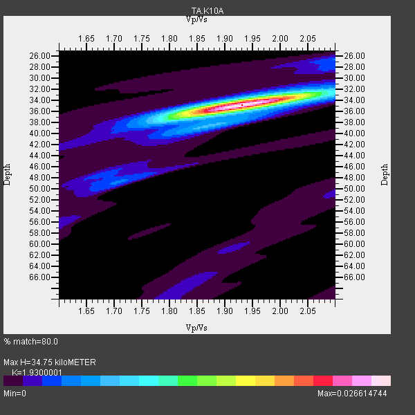
| Thickness Estimate: | 35 km |
| Thickness StdDev: | 0.3 km |
| Vp/Vs Estimate: | 1.93 |
| Vp/Vs StdDev: | 0.02 |
| Vs Estimate: | 3.26 km/s |
| Poisson's Ratio: | 0.32 |
| Peak Value: | 0.03 |
| Assumed Vp: | 6.291 km/s |
| Ps Weight: | 0.33333334 |
| PpPs Weight: | 0.33333334 |
| PsPs Weight: | 0.33333328 |
| Residual Complexity: | 0.239 |
| Nearby stations H: | +- |
| (2.0 deg) Vp/Vs: | +- |
24 with match > 90% ( 63.157894 %) and 38 with match > 80% ( 100.0 %) out of 38.
Download stack as xyz text file.
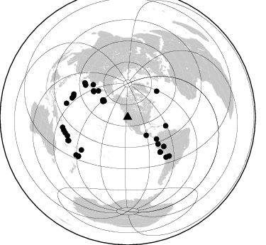
Azimuth Distribution of Events:
Prior Results for this Station
| Study | Thickness | Vp/Vs | Vp | Vs | Poissons Ratio | Extra |
| EARS | 35 km | 1.93 | 6.291 km/s | 3.26 km/s | 0.32 | |
| Crust2.0 | 40 km | 1.78 | 6.291 km/s | 3.539 km/s | 0.27 | M9,thick extended crust, 0.5 km seds. |
| Global Maxima | 35 km | 1.93 | 6.291 km/s | 3.26 km/s | 0.32 | amp=0.026614744 |
| Local Maxima 1 | 34 km | 1.97 | 6.291 km/s | 3.194 km/s | 0.33 | amp=0.005562243 |
| Local Maxima 2 | 49 km | 1.71 | 6.291 km/s | 3.684 km/s | 0.24 | amp=0.003820934 |
| Local Maxima 3 | 26 km | 2.10 | 6.291 km/s | 2.999 km/s | 0.35 | amp=0.0037518395 |
| Local Maxima 4 | 38 km | 1.80 | 6.291 km/s | 3.5 km/s | 0.28 | amp=0.0033557434 |
| Predicted Arrivals for vertical incidence (zero ray parameter) | |
| Ps | 5.14 SECOND |
| PpPs | 16.18 SECOND |
| PsPs/PpSs | 21.32 SECOND |
Events Processed for this Station
Download zip of receiver functions as SAC
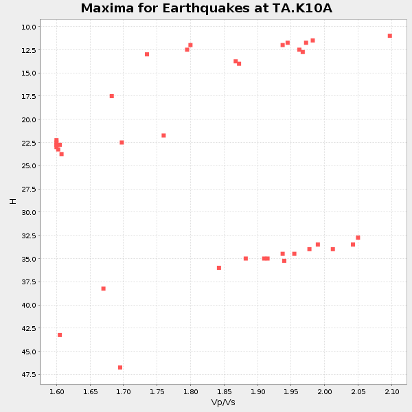
Plot maxima for each earthquake.
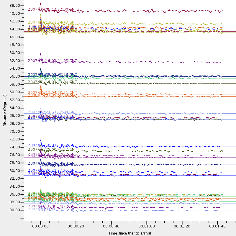
Events Used in the Stack
(38 events)| Radial Match | Distance | Baz | FERegion | Time | Lat/Lon | Depth | Magnitude |
| 98.97736 | 88.7 deg | 253.005 deg | Santa Cruz Islands | 2007/09/02 01:05:18 GMT | (-11.6, 165.8) | 35 km | 5.9 MB, 7.3 MS, 7.2 MW, 6.9 ME |
| 98.25736 | 92.8 deg | 261.17 deg | Solomon Islands | 2007/04/01 20:39:56 GMT | (-8.5, 157.0) | 10 km | 6.8 MB, 7.9 MS, 8.1 MW, 7.7 ME |
| 98.15582 | 60.0 deg | 306.779 deg | East Of Kuril Islands | 2007/01/13 04:23:21 GMT | (46.2, 154.5) | 10 km | 7.3 MB, 8.2 MS, 8.1 MW, 7.9 MW |
| 97.90229 | 90.1 deg | 248.867 deg | Vanuatu Islands | 2007/08/01 17:08:51 GMT | (-15.6, 167.7) | 120 km | 6.2 MB, 7.2 MW, 7.2 MW |
| 97.54439 | 77.8 deg | 136.141 deg | Northern Chile | 2007/11/14 15:40:50 GMT | (-22.2, -69.9) | 40 km | 6.7 MB, 7.4 MS, 7.7 MW, 7.4 ME |
| 97.46733 | 67.0 deg | 136.886 deg | Near Coast Of Peru | 2007/08/15 23:40:57 GMT | (-13.4, -76.6) | 39 km | 6.7 MB, 7.9 MS, 8.0 MW, 7.5 ME |
| 97.020935 | 88.3 deg | 231.698 deg | South Of Fiji Islands | 2007/12/09 07:28:20 GMT | (-26.0, -177.5) | 152 km | 7.0 MB, 7.8 MW, 7.7 MW |
| 96.99166 | 82.7 deg | 293.06 deg | Volcano Islands, Japan Region | 2007/09/28 13:38:59 GMT | (22.0, 142.7) | 276 km | 6.7 MB, 7.4 MW, 7.4 MW |
| 96.41522 | 55.5 deg | 311.794 deg | Kamchatka Peninsula, Russia | 2007/05/30 20:22:12 GMT | (52.1, 157.3) | 116 km | 6.4 MB, 6.4 MW, 6.4 MW |
| 96.12034 | 57.0 deg | 131.398 deg | Peru-Ecuador Border Region | 2007/11/16 03:13:00 GMT | (-2.3, -77.8) | 123 km | 6.3 MB, 6.8 MW, 6.7 MW |
| 96.06606 | 42.3 deg | 304.217 deg | Andreanof Islands, Aleutian Is. | 2007/12/19 09:30:27 GMT | (51.4, -179.5) | 29 km | 6.4 MB, 7.1 MS, 7.1 MW, 7.0 MW |
| 95.68797 | 92.0 deg | 258.544 deg | Solomon Islands | 2007/08/16 08:39:27 GMT | (-9.8, 159.5) | 10 km | 6.1 MB, 6.7 MS, 6.4 MW |
| 95.514656 | 51.0 deg | 127.244 deg | South Of Panama | 2007/03/18 02:11:05 GMT | (4.6, -78.5) | 8.0 km | 6.4 MB, 5.7 MS, 6.2 MW, 6.1 MW |
| 95.39718 | 54.9 deg | 102.745 deg | Windward Islands | 2007/11/29 19:00:19 GMT | (15.0, -61.3) | 148 km | 6.9 MB, 7.4 MW, 7.4 MW |
| 95.28284 | 89.4 deg | 248.395 deg | Vanuatu Islands | 2007/07/15 09:27:34 GMT | (-15.4, 168.6) | 8.0 km | 6.0 MB, 5.8 MS, 6.1 MW, 6.0 MW |
| 95.147575 | 74.8 deg | 307.168 deg | Near West Coast Of Honshu, Japan | 2007/07/16 01:13:22 GMT | (37.5, 138.4) | 12 km | 6.5 MB, 6.4 MS, 6.6 MW, 6.5 MW |
| 94.68358 | 77.4 deg | 308.656 deg | Sea Of Japan | 2007/07/16 14:17:37 GMT | (36.8, 134.9) | 350 km | 6.2 MB, 6.8 MW, 6.8 MW |
| 94.14744 | 88.4 deg | 282.631 deg | South Of Mariana Islands | 2007/09/30 02:08:30 GMT | (10.5, 145.7) | 14 km | 6.4 MB, 7.1 MS, 6.9 MW, 6.9 MW |
| 93.874 | 40.3 deg | 304.256 deg | Andreanof Islands, Aleutian Is. | 2007/07/13 21:54:43 GMT | (51.8, -176.3) | 35 km | 5.7 MB, 5.6 MS, 6.0 MW, 5.9 MW |
| 93.626755 | 79.9 deg | 132.884 deg | Jujuy Province, Argentina | 2007/07/21 15:34:52 GMT | (-22.2, -65.8) | 290 km | 5.8 MB, 6.4 MW, 6.3 MW |
| 93.59644 | 41.4 deg | 302.253 deg | Andreanof Islands, Aleutian Is. | 2007/08/15 20:22:11 GMT | (50.3, -177.5) | 9.0 km | 6.3 MB, 6.2 MS, 6.4 MW, 5.9 ML |
| 93.085075 | 67.2 deg | 137.006 deg | Near Coast Of Peru | 2007/08/17 13:18:13 GMT | (-13.6, -76.6) | 48 km | 5.6 MB, 5.6 MS, 5.9 MW |
| 92.53648 | 82.9 deg | 289.032 deg | Mariana Islands | 2007/10/31 03:30:17 GMT | (18.9, 145.4) | 223 km | 6.2 MB, 7.2 MW, 7.2 MW |
| 92.204704 | 66.7 deg | 313.189 deg | Sakhalin, Russia | 2007/08/02 02:37:42 GMT | (47.1, 141.8) | 5.0 km | 6.2 MS, 5.3 MB, 6.2 MW, 6.2 MW |
| 88.00004 | 42.0 deg | 304.091 deg | Andreanof Islands, Aleutian Is. | 2007/12/21 07:24:34 GMT | (51.4, -179.0) | 30 km | 6.1 MB, 6.2 MW, 6.3 ML |
| 87.63341 | 90.8 deg | 255.927 deg | Solomon Islands | 2007/11/27 11:49:58 GMT | (-10.9, 162.1) | 16 km | 5.9 MB, 6.7 MS, 6.6 MW, 6.4 MW |
| 87.6255 | 41.7 deg | 305.233 deg | Andreanof Islands, Aleutian Is. | 2008/03/22 21:24:11 GMT | (52.2, -178.7) | 132 km | 5.8 MB, 6.2 MW, 6.1 MW |
| 86.61053 | 67.2 deg | 137.032 deg | Near Coast Of Peru | 2007/08/19 01:22:40 GMT | (-13.6, -76.6) | 26 km | 5.9 MB, 5.4 MS, 5.8 MW, 5.5 ML |
| 85.788055 | 76.0 deg | 308.058 deg | Near West Coast Of Honshu, Japan | 2007/03/25 00:41:57 GMT | (37.3, 136.6) | 8.0 km | 6.1 MB, 6.8 MS, 6.7 MW, 6.6 MW |
| 85.131905 | 55.0 deg | 48.235 deg | Northern Mid-Atlantic Ridge | 2007/05/23 04:41:46 GMT | (52.4, -31.8) | 10 km | 5.6 MS, 5.4 MB, 5.7 MW, 5.6 MW |
| 85.05385 | 60.7 deg | 307.51 deg | Kuril Islands | 2008/03/03 09:31:02 GMT | (46.4, 153.2) | 10 km | 6.2 MB, 6.5 MS, 6.5 MW, 6.5 MW |
| 84.765434 | 42.6 deg | 304.238 deg | Andreanof Islands, Aleutian Is. | 2007/08/02 03:21:42 GMT | (51.3, -180.0) | 21 km | 6.3 MB, 6.6 MS, 6.7 MW, 6.6 MW |
| 83.929474 | 79.9 deg | 234.836 deg | Tonga Islands | 2007/08/26 12:37:31 GMT | (-17.5, -174.3) | 127 km | 5.9 MB, 6.1 MW |
| 83.57065 | 82.0 deg | 291.002 deg | Mariana Islands | 2007/01/30 21:37:45 GMT | (21.0, 144.7) | 30 km | 6.3 MB, 6.5 MS, 6.6 MW, 6.5 MW |
| 83.16622 | 88.6 deg | 231.661 deg | South Of Fiji Islands | 2007/07/18 00:07:35 GMT | (-26.3, -177.7) | 10 km | 5.8 MB, 5.9 MS, 6.1 MW, 6.0 MW |
| 81.19379 | 89.9 deg | 233.864 deg | South Of Fiji Islands | 2007/10/16 21:05:43 GMT | (-25.8, 179.5) | 509 km | 6.2 MB, 6.6 MW, 6.5 MW |
| 80.986824 | 65.5 deg | 128.973 deg | Western Brazil | 2007/07/21 13:27:04 GMT | (-8.1, -71.3) | 645 km | 6.2 MB, 6.1 MW, 6.0 MW |
| 80.33746 | 36.6 deg | 134.178 deg | Near Coast Of Guatemala | 2007/06/08 13:32:00 GMT | (13.8, -90.8) | 48 km | 5.5 MB, 5.4 MS, 5.8 MW, 5.8 MW |
Losers
(0 events)| Radial Match | Distance | Baz | FERegion | Time | Lat/Lon | Depth | Magnitude | Reason |
