You are here: Home > Network List > TA - USArray Transportable Network (new EarthScope stations) Stations List
> Station K10A MacKenzie Ranch, Jordan Valley, OR, USA > Earthquake Result Viewer
K10A MacKenzie Ranch, Jordan Valley, OR, USA - Earthquake Result Viewer
| Earthquake location: |
Santa Cruz Islands |
| Earthquake latitude/longitude: |
-11.6/165.8 |
| Earthquake time(UTC): |
2007/09/02 (245) 01:05:18 GMT |
| Earthquake Depth: |
35 km |
| Earthquake Magnitude: |
5.9 MB, 7.3 MS, 7.2 MW, 6.9 ME |
| Earthquake Catalog/Contributor: |
WHDF/NEIC |
|
| Network: |
TA USArray Transportable Network (new EarthScope stations) |
| Station: |
K10A MacKenzie Ranch, Jordan Valley, OR, USA |
| Lat/Lon: |
42.78 N/116.87 W |
| Elevation: |
1701 m |
|
| Distance: |
88.7 deg |
| Az: |
45.941 deg |
| Baz: |
253.005 deg |
| Ray Param: |
0.042335134 |
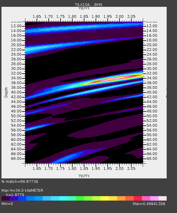
| Estimated Moho Depth: |
34.0 km |
| Estimated Crust Vp/Vs: |
1.98 |
| Assumed Crust Vp: |
6.291 km/s |
| Estimated Crust Vs: |
3.181 km/s |
| Estimated Crust Poisson's Ratio: |
0.33 |
|
| Radial Match: |
98.97736 % |
| Radial Bump: |
208 |
| Transverse Match: |
83.45328 % |
| Transverse Bump: |
400 |
| SOD ConfigId: |
2564 |
| Insert Time: |
2010-03-07 04:22:32.036 +0000 |
| GWidth: |
2.5 |
| Max Bumps: |
400 |
| Tol: |
0.001 |
|
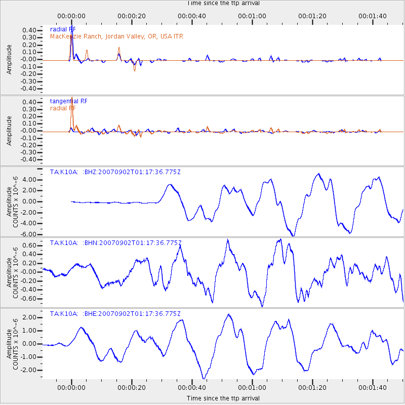
Signal To Noise
| Channel | StoN | STA | LTA |
| TA:K10A: :BHN:20070902T01:17:36.775Z | 2.5738904 | 1.5083587E-7 | 5.8602286E-8 |
| TA:K10A: :BHE:20070902T01:17:36.775Z | 20.67279 | 8.632915E-7 | 4.1759797E-8 |
| TA:K10A: :BHZ:20070902T01:17:36.775Z | 31.638617 | 2.3350624E-6 | 7.380419E-8 |
| Arrivals |
| Ps | 5.4 SECOND |
| PpPs | 16 SECOND |
| PsPs/PpSs | 21 SECOND |


