You are here: Home > Network List > TA - USArray Transportable Network (new EarthScope stations) Stations List
> Station K10A MacKenzie Ranch, Jordan Valley, OR, USA > Earthquake Result Viewer
K10A MacKenzie Ranch, Jordan Valley, OR, USA - Earthquake Result Viewer
| Earthquake location: |
Near Coast Of Guatemala |
| Earthquake latitude/longitude: |
13.8/-90.8 |
| Earthquake time(UTC): |
2007/06/08 (159) 13:32:00 GMT |
| Earthquake Depth: |
48 km |
| Earthquake Magnitude: |
5.5 MB, 5.4 MS, 5.8 MW, 5.8 MW |
| Earthquake Catalog/Contributor: |
WHDF/NEIC |
|
| Network: |
TA USArray Transportable Network (new EarthScope stations) |
| Station: |
K10A MacKenzie Ranch, Jordan Valley, OR, USA |
| Lat/Lon: |
42.78 N/116.87 W |
| Elevation: |
1701 m |
|
| Distance: |
36.6 deg |
| Az: |
327.071 deg |
| Baz: |
134.178 deg |
| Ray Param: |
0.076486096 |
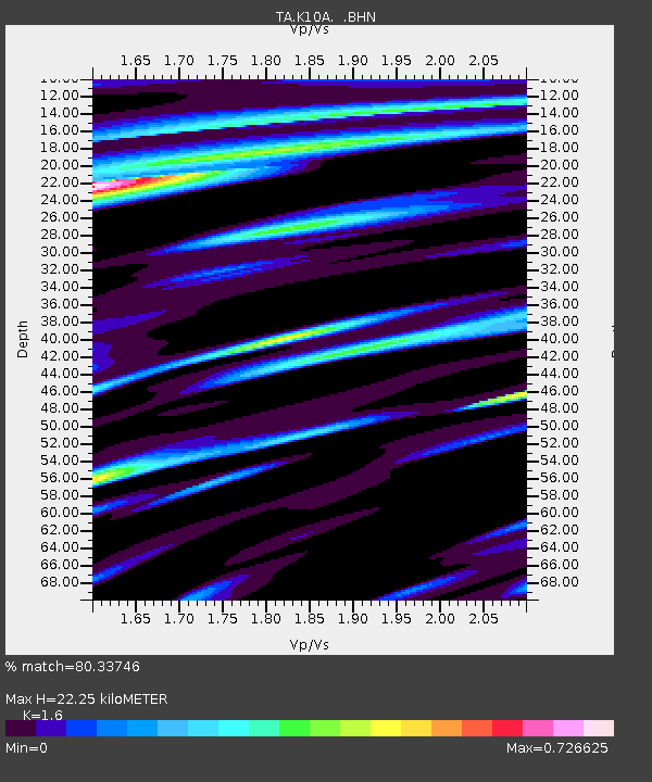
| Estimated Moho Depth: |
22.25 km |
| Estimated Crust Vp/Vs: |
1.60 |
| Assumed Crust Vp: |
6.291 km/s |
| Estimated Crust Vs: |
3.932 km/s |
| Estimated Crust Poisson's Ratio: |
0.18 |
|
| Radial Match: |
80.33746 % |
| Radial Bump: |
400 |
| Transverse Match: |
59.909763 % |
| Transverse Bump: |
400 |
| SOD ConfigId: |
2564 |
| Insert Time: |
2010-03-07 04:23:02.105 +0000 |
| GWidth: |
2.5 |
| Max Bumps: |
400 |
| Tol: |
0.001 |
|
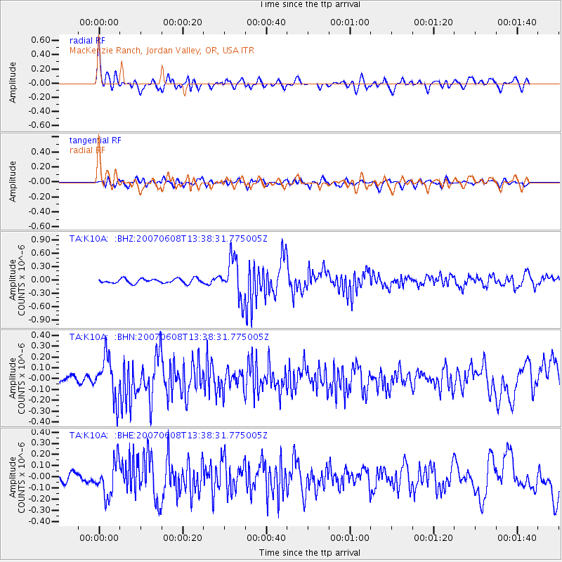
Signal To Noise
| Channel | StoN | STA | LTA |
| TA:K10A: :BHN:20070608T13:38:31.775005Z | 8.54184 | 1.9642611E-7 | 2.2995762E-8 |
| TA:K10A: :BHE:20070608T13:38:31.775005Z | 3.5608017 | 1.5797913E-7 | 4.4366168E-8 |
| TA:K10A: :BHZ:20070608T13:38:31.775005Z | 8.902155 | 4.5902533E-7 | 5.1563394E-8 |
| Arrivals |
| Ps | 2.3 SECOND |
| PpPs | 8.5 SECOND |
| PsPs/PpSs | 11 SECOND |


