You are here: Home > Network List > TA - USArray Transportable Network (new EarthScope stations) Stations List
> Station K10A MacKenzie Ranch, Jordan Valley, OR, USA > Earthquake Result Viewer
K10A MacKenzie Ranch, Jordan Valley, OR, USA - Earthquake Result Viewer
| Earthquake location: |
Near West Coast Of Honshu, Japan |
| Earthquake latitude/longitude: |
37.3/136.6 |
| Earthquake time(UTC): |
2007/03/25 (084) 00:41:57 GMT |
| Earthquake Depth: |
8.0 km |
| Earthquake Magnitude: |
6.1 MB, 6.8 MS, 6.7 MW, 6.6 MW |
| Earthquake Catalog/Contributor: |
WHDF/NEIC |
|
| Network: |
TA USArray Transportable Network (new EarthScope stations) |
| Station: |
K10A MacKenzie Ranch, Jordan Valley, OR, USA |
| Lat/Lon: |
42.78 N/116.87 W |
| Elevation: |
1701 m |
|
| Distance: |
76.0 deg |
| Az: |
46.663 deg |
| Baz: |
308.058 deg |
| Ray Param: |
0.051279724 |
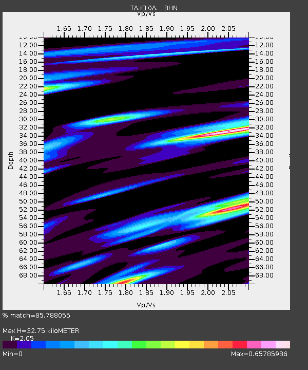
| Estimated Moho Depth: |
32.75 km |
| Estimated Crust Vp/Vs: |
2.05 |
| Assumed Crust Vp: |
6.291 km/s |
| Estimated Crust Vs: |
3.069 km/s |
| Estimated Crust Poisson's Ratio: |
0.34 |
|
| Radial Match: |
85.788055 % |
| Radial Bump: |
400 |
| Transverse Match: |
71.593376 % |
| Transverse Bump: |
400 |
| SOD ConfigId: |
2564 |
| Insert Time: |
2010-03-07 04:23:08.736 +0000 |
| GWidth: |
2.5 |
| Max Bumps: |
400 |
| Tol: |
0.001 |
|
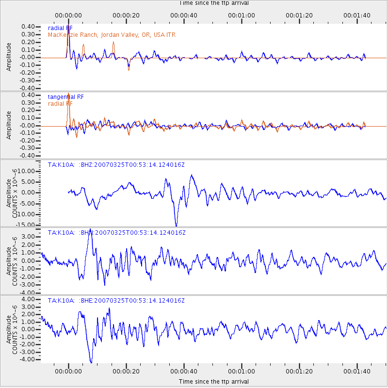
Signal To Noise
| Channel | StoN | STA | LTA |
| TA:K10A: :BHN:20070325T00:53:14.124016Z | 1.9985354 | 9.410861E-7 | 4.708879E-7 |
| TA:K10A: :BHE:20070325T00:53:14.124016Z | 1.2466058 | 1.1730483E-6 | 9.409938E-7 |
| TA:K10A: :BHZ:20070325T00:53:14.124016Z | 1.0090607 | 2.8651177E-6 | 2.8393906E-6 |
| Arrivals |
| Ps | 5.6 SECOND |
| PpPs | 15 SECOND |
| PsPs/PpSs | 21 SECOND |


