You are here: Home > Network List > TA - USArray Transportable Network (new EarthScope stations) Stations List
> Station K10A MacKenzie Ranch, Jordan Valley, OR, USA > Earthquake Result Viewer
K10A MacKenzie Ranch, Jordan Valley, OR, USA - Earthquake Result Viewer
| Earthquake location: |
South Of Panama |
| Earthquake latitude/longitude: |
4.6/-78.5 |
| Earthquake time(UTC): |
2007/03/18 (077) 02:11:05 GMT |
| Earthquake Depth: |
8.0 km |
| Earthquake Magnitude: |
6.4 MB, 5.7 MS, 6.2 MW, 6.1 MW |
| Earthquake Catalog/Contributor: |
WHDF/NEIC |
|
| Network: |
TA USArray Transportable Network (new EarthScope stations) |
| Station: |
K10A MacKenzie Ranch, Jordan Valley, OR, USA |
| Lat/Lon: |
42.78 N/116.87 W |
| Elevation: |
1701 m |
|
| Distance: |
51.0 deg |
| Az: |
323.987 deg |
| Baz: |
127.244 deg |
| Ray Param: |
0.06768545 |
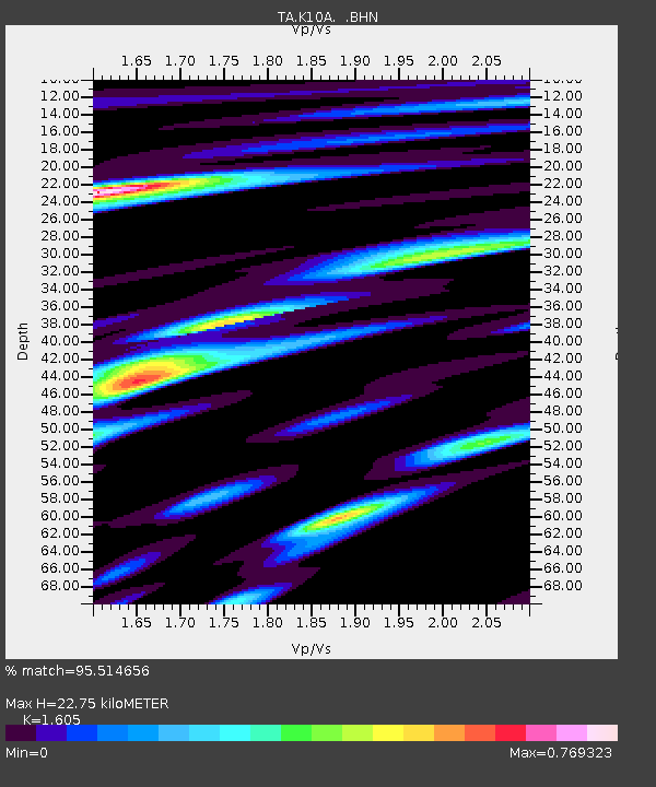
| Estimated Moho Depth: |
22.75 km |
| Estimated Crust Vp/Vs: |
1.61 |
| Assumed Crust Vp: |
6.291 km/s |
| Estimated Crust Vs: |
3.92 km/s |
| Estimated Crust Poisson's Ratio: |
0.18 |
|
| Radial Match: |
95.514656 % |
| Radial Bump: |
400 |
| Transverse Match: |
77.72781 % |
| Transverse Bump: |
400 |
| SOD ConfigId: |
2564 |
| Insert Time: |
2010-03-07 04:23:10.487 +0000 |
| GWidth: |
2.5 |
| Max Bumps: |
400 |
| Tol: |
0.001 |
|
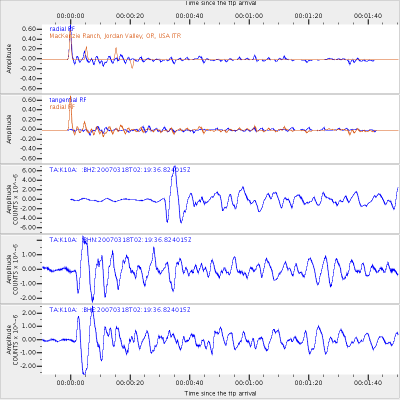
Signal To Noise
| Channel | StoN | STA | LTA |
| TA:K10A: :BHN:20070318T02:19:36.824015Z | 6.8527756 | 1.0283985E-6 | 1.5007035E-7 |
| TA:K10A: :BHE:20070318T02:19:36.824015Z | 11.279465 | 1.2391357E-6 | 1.09857666E-7 |
| TA:K10A: :BHZ:20070318T02:19:36.824015Z | 16.820015 | 2.952076E-6 | 1.7550973E-7 |
| Arrivals |
| Ps | 2.3 SECOND |
| PpPs | 8.9 SECOND |
| PsPs/PpSs | 11 SECOND |


