You are here: Home > Network List > TA - USArray Transportable Network (new EarthScope stations) Stations List
> Station K10A MacKenzie Ranch, Jordan Valley, OR, USA > Earthquake Result Viewer
K10A MacKenzie Ranch, Jordan Valley, OR, USA - Earthquake Result Viewer
| Earthquake location: |
Mariana Islands |
| Earthquake latitude/longitude: |
21.0/144.7 |
| Earthquake time(UTC): |
2007/01/30 (030) 21:37:45 GMT |
| Earthquake Depth: |
30 km |
| Earthquake Magnitude: |
6.3 MB, 6.5 MS, 6.6 MW, 6.5 MW |
| Earthquake Catalog/Contributor: |
WHDF/NEIC |
|
| Network: |
TA USArray Transportable Network (new EarthScope stations) |
| Station: |
K10A MacKenzie Ranch, Jordan Valley, OR, USA |
| Lat/Lon: |
42.78 N/116.87 W |
| Elevation: |
1701 m |
|
| Distance: |
82.0 deg |
| Az: |
47.353 deg |
| Baz: |
291.002 deg |
| Ray Param: |
0.047187496 |
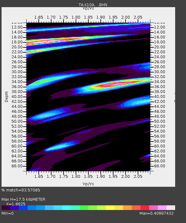
| Estimated Moho Depth: |
17.5 km |
| Estimated Crust Vp/Vs: |
1.68 |
| Assumed Crust Vp: |
6.291 km/s |
| Estimated Crust Vs: |
3.739 km/s |
| Estimated Crust Poisson's Ratio: |
0.23 |
|
| Radial Match: |
83.57065 % |
| Radial Bump: |
369 |
| Transverse Match: |
63.953884 % |
| Transverse Bump: |
400 |
| SOD ConfigId: |
2564 |
| Insert Time: |
2010-03-07 04:23:12.373 +0000 |
| GWidth: |
2.5 |
| Max Bumps: |
400 |
| Tol: |
0.001 |
|
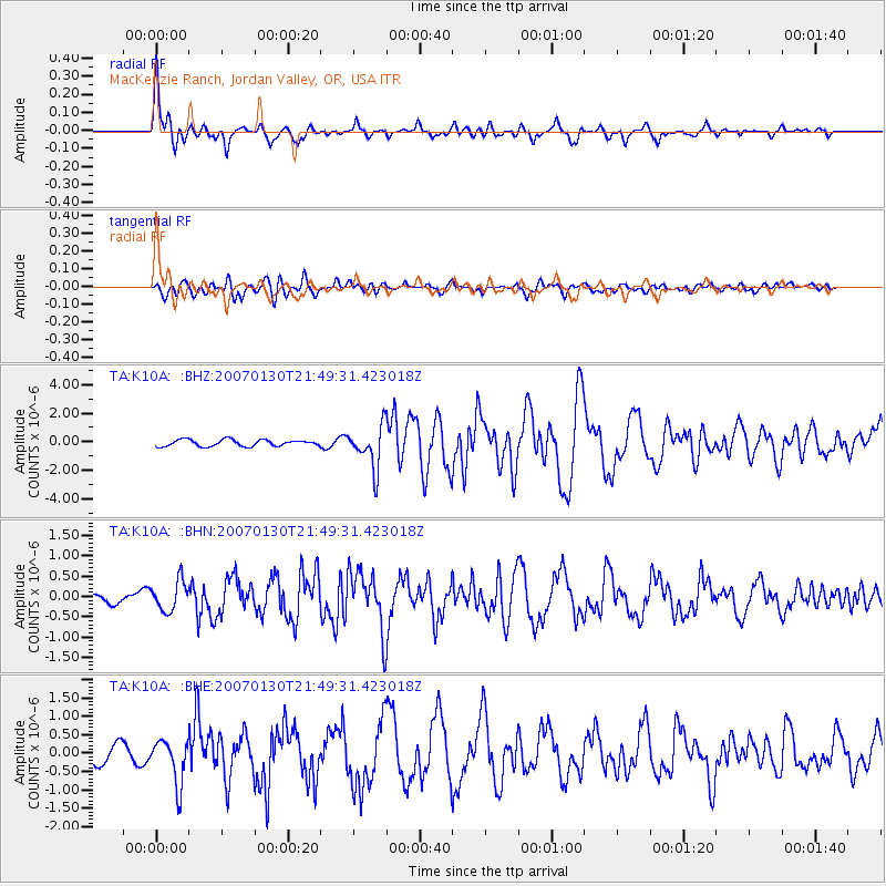
Signal To Noise
| Channel | StoN | STA | LTA |
| TA:K10A: :BHN:20070130T21:49:31.423018Z | 1.3459882 | 3.6624937E-7 | 2.7210444E-7 |
| TA:K10A: :BHE:20070130T21:49:31.423018Z | 2.2823036 | 5.976686E-7 | 2.6187075E-7 |
| TA:K10A: :BHZ:20070130T21:49:31.423018Z | 6.4779763 | 1.4892208E-6 | 2.298898E-7 |
| Arrivals |
| Ps | 2.0 SECOND |
| PpPs | 7.3 SECOND |
| PsPs/PpSs | 9.2 SECOND |


