You are here: Home > Network List > TA - USArray Transportable Network (new EarthScope stations) Stations List
> Station D11A Klaveano Farm, Fernwood, ID, USA > Earthquake Result Viewer
D11A Klaveano Farm, Fernwood, ID, USA - Earthquake Result Viewer
| Earthquake location: |
South Of Mariana Islands |
| Earthquake latitude/longitude: |
10.5/145.7 |
| Earthquake time(UTC): |
2007/09/30 (273) 02:08:30 GMT |
| Earthquake Depth: |
14 km |
| Earthquake Magnitude: |
6.4 MB, 7.1 MS, 6.9 MW, 6.9 MW |
| Earthquake Catalog/Contributor: |
WHDF/NEIC |
|
| Network: |
TA USArray Transportable Network (new EarthScope stations) |
| Station: |
D11A Klaveano Farm, Fernwood, ID, USA |
| Lat/Lon: |
47.05 N/116.34 W |
| Elevation: |
849 m |
|
| Distance: |
87.8 deg |
| Az: |
42.67 deg |
| Baz: |
282.865 deg |
| Ray Param: |
0.043060385 |
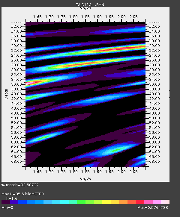
| Estimated Moho Depth: |
35.5 km |
| Estimated Crust Vp/Vs: |
1.60 |
| Assumed Crust Vp: |
6.571 km/s |
| Estimated Crust Vs: |
4.107 km/s |
| Estimated Crust Poisson's Ratio: |
0.18 |
|
| Radial Match: |
92.50727 % |
| Radial Bump: |
400 |
| Transverse Match: |
89.051544 % |
| Transverse Bump: |
400 |
| SOD ConfigId: |
2564 |
| Insert Time: |
2010-03-07 04:28:40.428 +0000 |
| GWidth: |
2.5 |
| Max Bumps: |
400 |
| Tol: |
0.001 |
|

Signal To Noise
| Channel | StoN | STA | LTA |
| TA:D11A: :BHN:20070930T02:20:47.149004Z | 1.2338237 | 1.9814671E-7 | 1.6059563E-7 |
| TA:D11A: :BHE:20070930T02:20:47.149004Z | 1.8945571 | 1.7092881E-7 | 9.0220986E-8 |
| TA:D11A: :BHZ:20070930T02:20:47.149004Z | 3.6645343 | 5.56136E-7 | 1.5176171E-7 |
| Arrivals |
| Ps | 3.3 SECOND |
| PpPs | 14 SECOND |
| PsPs/PpSs | 17 SECOND |


