
Station TA D11A - Klaveano Farm, Fernwood, ID, USA
Network: TA - USArray Transportable Network (new EarthScope stations)
Nearby stations (2 deg radius)
| Station | Name | (Lat, Lon) | Start / End | Elevation |
| D11A | Klaveano Farm, Fernwood, ID, USA | (47.05, -116.34) | 2006-11-11 / 2499-01-01 | 0.8 km |
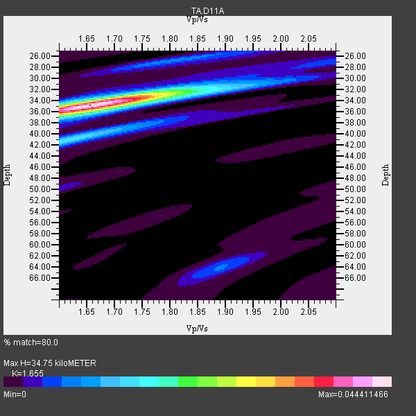
| Crust2 Type: | Q9,orogen/41km no ice, cordilleras, 0.25 km seds. |
| Thickness Estimate: | 35 km |
| Thickness StdDev: | 0.4 km |
| Vp/Vs Estimate: | 1.65 |
| Vp/Vs StdDev: | 0.02 |
| Vs Estimate: | 3.97 km/s |
| Poisson's Ratio: | 0.21 |
| Peak Value: | 0.04 |
| Assumed Vp: | 6.571 km/s |
| Ps Weight: | 0.33333334 |
| PpPs Weight: | 0.33333334 |
| PsPs Weight: | 0.33333328 |
| Residual Complexity: | 0.371 |
| Nearby stations H: | +- |
| (2.0 deg) Vp/Vs: | +- |
10 with match > 90% ( 40.0 %) and 25 with match > 80% ( 100.0 %) out of 25.
Download stack as xyz text file.
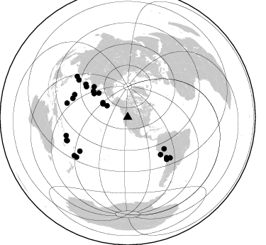
Azimuth Distribution of Events:
Prior Results for this Station
| Study | Thickness | Vp/Vs | Vp | Vs | Poissons Ratio | Extra |
| EARS | 35 km | 1.65 | 6.571 km/s | 3.97 km/s | 0.21 | |
| Crust2.0 | 41 km | 1.76 | 6.571 km/s | 3.735 km/s | 0.26 | Q9,orogen/41km no ice, cordilleras, 0.25 km seds. |
| Global Maxima | 35 km | 1.65 | 6.571 km/s | 3.97 km/s | 0.21 | amp=0.044411466 |
| Local Maxima 1 | 41 km | 1.62 | 6.571 km/s | 4.062 km/s | 0.19 | amp=0.014584885 |
| Local Maxima 2 | 34 km | 1.73 | 6.571 km/s | 3.809 km/s | 0.25 | amp=0.009043614 |
| Local Maxima 3 | 27 km | 1.80 | 6.571 km/s | 3.65 km/s | 0.28 | amp=0.00740343 |
| Local Maxima 4 | 64 km | 1.89 | 6.571 km/s | 3.472 km/s | 0.31 | amp=0.0068331496 |
| Predicted Arrivals for vertical incidence (zero ray parameter) | |
| Ps | 3.46 SECOND |
| PpPs | 14.04 SECOND |
| PsPs/PpSs | 17.51 SECOND |
Events Processed for this Station
Download zip of receiver functions as SAC
Plot maxima for each earthquake.
Events Used in the Stack
(25 events)| Radial Match | Distance | Baz | FERegion | Time | Lat/Lon | Depth | Magnitude |
| 98.22357 | 90.3 deg | 253.348 deg | Santa Cruz Islands | 2007/09/02 01:05:18 GMT | (-11.6, 165.8) | 35 km | 5.9 MB, 7.3 MS, 7.2 MW, 6.9 ME |
| 96.69888 | 92.0 deg | 249.317 deg | Vanuatu Islands | 2007/08/01 17:08:51 GMT | (-15.6, 167.7) | 120 km | 6.2 MB, 7.2 MW, 7.2 MW |
| 95.91265 | 80.7 deg | 137.126 deg | Northern Chile | 2007/11/14 15:40:50 GMT | (-22.2, -69.9) | 40 km | 6.7 MB, 7.4 MS, 7.7 MW, 7.4 ME |
| 95.85625 | 91.2 deg | 232.062 deg | South Of Fiji Islands | 2007/12/09 07:28:20 GMT | (-26.0, -177.5) | 152 km | 7.0 MB, 7.8 MW, 7.7 MW |
| 94.74491 | 81.3 deg | 292.863 deg | Volcano Islands, Japan Region | 2007/09/28 13:38:59 GMT | (22.0, 142.7) | 276 km | 6.7 MB, 7.4 MW, 7.4 MW |
| 93.129265 | 81.9 deg | 288.852 deg | Mariana Islands | 2007/10/31 03:30:17 GMT | (18.9, 145.4) | 223 km | 6.2 MB, 7.2 MW, 7.2 MW |
| 92.50727 | 87.8 deg | 282.865 deg | South Of Mariana Islands | 2007/09/30 02:08:30 GMT | (10.5, 145.7) | 14 km | 6.4 MB, 7.1 MS, 6.9 MW, 6.9 MW |
| 91.61166 | 91.3 deg | 248.794 deg | Vanuatu Islands | 2007/07/15 09:27:34 GMT | (-15.4, 168.6) | 8.0 km | 6.0 MB, 5.8 MS, 6.1 MW, 6.0 MW |
| 91.32957 | 64.1 deg | 312.008 deg | Sakhalin, Russia | 2007/08/02 02:37:42 GMT | (47.1, 141.8) | 5.0 km | 6.2 MS, 5.3 MB, 6.2 MW, 6.2 MW |
| 90.9406 | 75.0 deg | 308.153 deg | Sea Of Japan | 2007/07/16 14:17:37 GMT | (36.8, 134.9) | 350 km | 6.2 MB, 6.8 MW, 6.8 MW |
| 89.55191 | 53.0 deg | 309.666 deg | Kamchatka Peninsula, Russia | 2007/05/30 20:22:12 GMT | (52.1, 157.3) | 116 km | 6.4 MB, 6.4 MW, 6.4 MW |
| 89.48375 | 40.4 deg | 300.258 deg | Andreanof Islands, Aleutian Is. | 2007/12/19 09:30:27 GMT | (51.4, -179.5) | 29 km | 6.4 MB, 7.1 MS, 7.1 MW, 7.0 MW |
| 89.06396 | 72.5 deg | 306.477 deg | Near West Coast Of Honshu, Japan | 2007/07/16 01:13:22 GMT | (37.5, 138.4) | 12 km | 6.5 MB, 6.4 MS, 6.6 MW, 6.5 MW |
| 88.44731 | 39.5 deg | 298.074 deg | Andreanof Islands, Aleutian Is. | 2007/08/15 20:22:11 GMT | (50.3, -177.5) | 9.0 km | 6.3 MB, 6.2 MS, 6.4 MW, 5.9 ML |
| 87.07913 | 33.2 deg | 298.854 deg | Fox Islands, Aleutian Islands | 2007/07/15 13:08:00 GMT | (52.5, -168.0) | 10 km | 5.8 MB, 5.9 MS, 6.1 MW, 6.0 MW |
| 86.76043 | 82.6 deg | 234.709 deg | Tonga Islands | 2007/08/26 12:37:31 GMT | (-17.5, -174.3) | 127 km | 5.9 MB, 6.1 MW |
| 86.12381 | 60.6 deg | 306.75 deg | Kuril Islands | 2007/09/03 16:14:53 GMT | (45.8, 150.1) | 94 km | 6.3 MB, 6.2 MW, 6.2 ME |
| 83.45558 | 82.6 deg | 133.78 deg | Jujuy Province, Argentina | 2007/07/21 15:34:52 GMT | (-22.2, -65.8) | 290 km | 5.8 MB, 6.4 MW, 6.3 MW |
| 83.43547 | 58.0 deg | 304.916 deg | East Of Kuril Islands | 2006/12/07 19:10:21 GMT | (46.2, 154.4) | 16 km | 6.3 MB, 6.1 MS, 6.3 MW, 6.3 MW |
| 83.14989 | 70.1 deg | 138.616 deg | Near Coast Of Peru | 2007/08/17 13:18:13 GMT | (-13.6, -76.6) | 48 km | 5.6 MB, 5.6 MS, 5.9 MW |
| 82.721596 | 67.9 deg | 130.865 deg | Western Brazil | 2007/07/21 13:27:04 GMT | (-8.1, -71.3) | 645 km | 6.2 MB, 6.1 MW, 6.0 MW |
| 82.19576 | 86.6 deg | 307.287 deg | Northwest Of Ryukyu Islands | 2007/07/31 15:07:35 GMT | (27.3, 126.9) | 10 km | 5.5 MB, 5.7 MS, 5.9 MW, 5.9 MW |
| 81.56318 | 78.8 deg | 136.188 deg | Near Coast Of Northern Chile | 2008/02/04 17:01:30 GMT | (-20.2, -70.0) | 44 km | 6.0 MB, 6.2 MS, 6.3 MW, 6.3 MW |
| 81.45821 | 92.7 deg | 234.312 deg | South Of Fiji Islands | 2007/10/16 21:05:43 GMT | (-25.8, 179.5) | 509 km | 6.2 MB, 6.6 MW, 6.5 MW |
| 80.16093 | 91.5 deg | 308.88 deg | Taiwan Region | 2007/09/06 17:51:26 GMT | (24.3, 122.2) | 53 km | 6.1 MB, 6.2 MW, 6.1 ME |
Losers
(0 events)| Radial Match | Distance | Baz | FERegion | Time | Lat/Lon | Depth | Magnitude | Reason |
