You are here: Home > Network List > TA - USArray Transportable Network (new EarthScope stations) Stations List
> Station D11A Klaveano Farm, Fernwood, ID, USA > Earthquake Result Viewer
D11A Klaveano Farm, Fernwood, ID, USA - Earthquake Result Viewer
| Earthquake location: |
Volcano Islands, Japan Region |
| Earthquake latitude/longitude: |
22.0/142.7 |
| Earthquake time(UTC): |
2007/09/28 (271) 13:38:59 GMT |
| Earthquake Depth: |
276 km |
| Earthquake Magnitude: |
6.7 MB, 7.4 MW, 7.4 MW |
| Earthquake Catalog/Contributor: |
WHDF/NEIC |
|
| Network: |
TA USArray Transportable Network (new EarthScope stations) |
| Station: |
D11A Klaveano Farm, Fernwood, ID, USA |
| Lat/Lon: |
47.05 N/116.34 W |
| Elevation: |
849 m |
|
| Distance: |
81.3 deg |
| Az: |
42.764 deg |
| Baz: |
292.863 deg |
| Ray Param: |
0.046937946 |
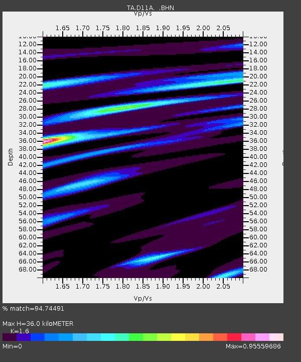
| Estimated Moho Depth: |
36.0 km |
| Estimated Crust Vp/Vs: |
1.60 |
| Assumed Crust Vp: |
6.571 km/s |
| Estimated Crust Vs: |
4.107 km/s |
| Estimated Crust Poisson's Ratio: |
0.18 |
|
| Radial Match: |
94.74491 % |
| Radial Bump: |
400 |
| Transverse Match: |
85.50829 % |
| Transverse Bump: |
400 |
| SOD ConfigId: |
2564 |
| Insert Time: |
2010-03-07 04:28:42.124 +0000 |
| GWidth: |
2.5 |
| Max Bumps: |
400 |
| Tol: |
0.001 |
|

Signal To Noise
| Channel | StoN | STA | LTA |
| TA:D11A: :BHN:20070928T13:50:14.273022Z | 46.042442 | 2.89165E-6 | 6.2804006E-8 |
| TA:D11A: :BHE:20070928T13:50:14.273022Z | 35.221706 | 3.5113467E-6 | 9.969269E-8 |
| TA:D11A: :BHZ:20070928T13:50:14.273022Z | 98.25628 | 1.2381363E-5 | 1.2601092E-7 |
| Arrivals |
| Ps | 3.4 SECOND |
| PpPs | 14 SECOND |
| PsPs/PpSs | 17 SECOND |


