You are here: Home > Network List > TA - USArray Transportable Network (new EarthScope stations) Stations List
> Station D11A Klaveano Farm, Fernwood, ID, USA > Earthquake Result Viewer
D11A Klaveano Farm, Fernwood, ID, USA - Earthquake Result Viewer
| Earthquake location: |
Northwest Of Ryukyu Islands |
| Earthquake latitude/longitude: |
27.3/126.9 |
| Earthquake time(UTC): |
2007/07/31 (212) 15:07:35 GMT |
| Earthquake Depth: |
10 km |
| Earthquake Magnitude: |
5.5 MB, 5.7 MS, 5.9 MW, 5.9 MW |
| Earthquake Catalog/Contributor: |
WHDF/NEIC |
|
| Network: |
TA USArray Transportable Network (new EarthScope stations) |
| Station: |
D11A Klaveano Farm, Fernwood, ID, USA |
| Lat/Lon: |
47.05 N/116.34 W |
| Elevation: |
849 m |
|
| Distance: |
86.6 deg |
| Az: |
37.708 deg |
| Baz: |
307.287 deg |
| Ray Param: |
0.043938406 |
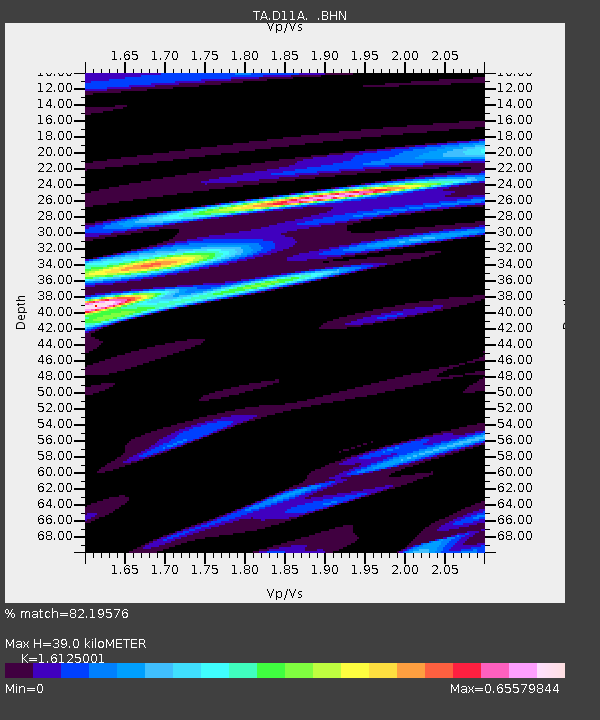
| Estimated Moho Depth: |
39.0 km |
| Estimated Crust Vp/Vs: |
1.61 |
| Assumed Crust Vp: |
6.571 km/s |
| Estimated Crust Vs: |
4.075 km/s |
| Estimated Crust Poisson's Ratio: |
0.19 |
|
| Radial Match: |
82.19576 % |
| Radial Bump: |
400 |
| Transverse Match: |
73.93878 % |
| Transverse Bump: |
400 |
| SOD ConfigId: |
2564 |
| Insert Time: |
2010-03-07 04:28:57.899 +0000 |
| GWidth: |
2.5 |
| Max Bumps: |
400 |
| Tol: |
0.001 |
|

Signal To Noise
| Channel | StoN | STA | LTA |
| TA:D11A: :BHN:20070731T15:19:47.200005Z | 0.73548853 | 4.1259753E-8 | 5.609843E-8 |
| TA:D11A: :BHE:20070731T15:19:47.200005Z | 1.0818641 | 4.33469E-8 | 4.0066865E-8 |
| TA:D11A: :BHZ:20070731T15:19:47.200005Z | 2.0528417 | 1.6631665E-7 | 8.101777E-8 |
| Arrivals |
| Ps | 3.7 SECOND |
| PpPs | 15 SECOND |
| PsPs/PpSs | 19 SECOND |


