You are here: Home > Network List > TA - USArray Transportable Network (new EarthScope stations) Stations List
> Station D11A Klaveano Farm, Fernwood, ID, USA > Earthquake Result Viewer
D11A Klaveano Farm, Fernwood, ID, USA - Earthquake Result Viewer
| Earthquake location: |
Western Brazil |
| Earthquake latitude/longitude: |
-8.1/-71.3 |
| Earthquake time(UTC): |
2007/07/21 (202) 13:27:04 GMT |
| Earthquake Depth: |
645 km |
| Earthquake Magnitude: |
6.2 MB, 6.1 MW, 6.0 MW |
| Earthquake Catalog/Contributor: |
WHDF/NEIC |
|
| Network: |
TA USArray Transportable Network (new EarthScope stations) |
| Station: |
D11A Klaveano Farm, Fernwood, ID, USA |
| Lat/Lon: |
47.05 N/116.34 W |
| Elevation: |
849 m |
|
| Distance: |
67.9 deg |
| Az: |
328.511 deg |
| Baz: |
130.865 deg |
| Ray Param: |
0.054266285 |
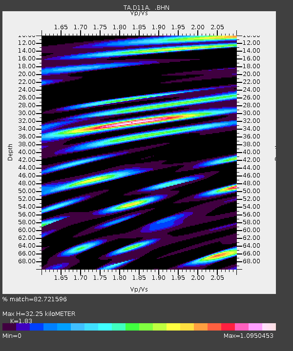
| Estimated Moho Depth: |
32.25 km |
| Estimated Crust Vp/Vs: |
1.83 |
| Assumed Crust Vp: |
6.571 km/s |
| Estimated Crust Vs: |
3.591 km/s |
| Estimated Crust Poisson's Ratio: |
0.29 |
|
| Radial Match: |
82.721596 % |
| Radial Bump: |
400 |
| Transverse Match: |
71.397545 % |
| Transverse Bump: |
400 |
| SOD ConfigId: |
2564 |
| Insert Time: |
2010-03-07 04:29:01.563 +0000 |
| GWidth: |
2.5 |
| Max Bumps: |
400 |
| Tol: |
0.001 |
|

Signal To Noise
| Channel | StoN | STA | LTA |
| TA:D11A: :BHN:20070721T13:36:30.149014Z | 9.743186 | 3.2734943E-7 | 3.3597782E-8 |
| TA:D11A: :BHE:20070721T13:36:30.149014Z | 7.6164684 | 3.2770865E-7 | 4.3026326E-8 |
| TA:D11A: :BHZ:20070721T13:36:30.149014Z | 16.389166 | 1.0508419E-6 | 6.411808E-8 |
| Arrivals |
| Ps | 4.2 SECOND |
| PpPs | 13 SECOND |
| PsPs/PpSs | 18 SECOND |


