You are here: Home > Network List > TA - USArray Transportable Network (new EarthScope stations) Stations List
> Station D11A Klaveano Farm, Fernwood, ID, USA > Earthquake Result Viewer
D11A Klaveano Farm, Fernwood, ID, USA - Earthquake Result Viewer
| Earthquake location: |
Near West Coast Of Honshu, Japan |
| Earthquake latitude/longitude: |
37.5/138.4 |
| Earthquake time(UTC): |
2007/07/16 (197) 01:13:22 GMT |
| Earthquake Depth: |
12 km |
| Earthquake Magnitude: |
6.5 MB, 6.4 MS, 6.6 MW, 6.5 MW |
| Earthquake Catalog/Contributor: |
WHDF/NEIC |
|
| Network: |
TA USArray Transportable Network (new EarthScope stations) |
| Station: |
D11A Klaveano Farm, Fernwood, ID, USA |
| Lat/Lon: |
47.05 N/116.34 W |
| Elevation: |
849 m |
|
| Distance: |
72.5 deg |
| Az: |
43.765 deg |
| Baz: |
306.477 deg |
| Ray Param: |
0.053585585 |
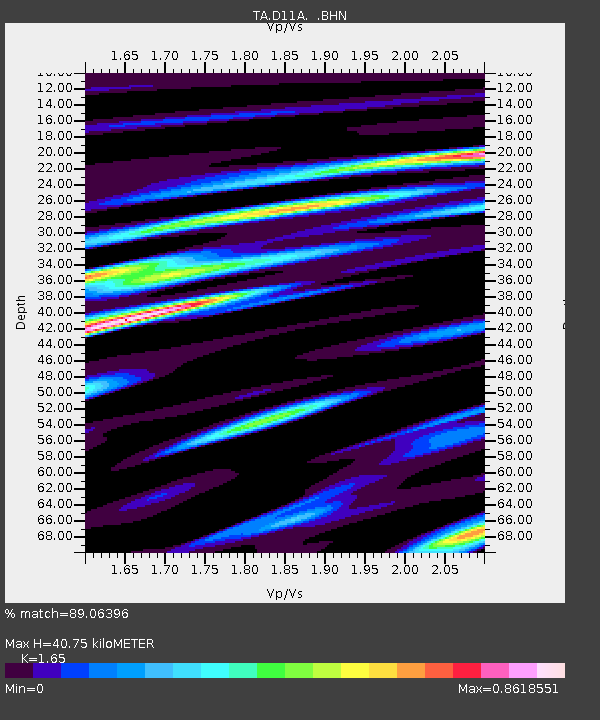
| Estimated Moho Depth: |
40.75 km |
| Estimated Crust Vp/Vs: |
1.65 |
| Assumed Crust Vp: |
6.571 km/s |
| Estimated Crust Vs: |
3.982 km/s |
| Estimated Crust Poisson's Ratio: |
0.21 |
|
| Radial Match: |
89.06396 % |
| Radial Bump: |
400 |
| Transverse Match: |
90.438416 % |
| Transverse Bump: |
400 |
| SOD ConfigId: |
2564 |
| Insert Time: |
2010-03-07 04:29:05.022 +0000 |
| GWidth: |
2.5 |
| Max Bumps: |
400 |
| Tol: |
0.001 |
|

Signal To Noise
| Channel | StoN | STA | LTA |
| TA:D11A: :BHN:20070716T01:24:17.825017Z | 18.474533 | 7.0238474E-7 | 3.8019078E-8 |
| TA:D11A: :BHE:20070716T01:24:17.825017Z | 10.812337 | 5.641148E-7 | 5.2173256E-8 |
| TA:D11A: :BHZ:20070716T01:24:17.825017Z | 41.870686 | 1.9143522E-6 | 4.5720583E-8 |
| Arrivals |
| Ps | 4.2 SECOND |
| PpPs | 16 SECOND |
| PsPs/PpSs | 20 SECOND |


