You are here: Home > Network List > TA - USArray Transportable Network (new EarthScope stations) Stations List
> Station A11A Hall Mountain, Copeland, ID, USA > Earthquake Result Viewer
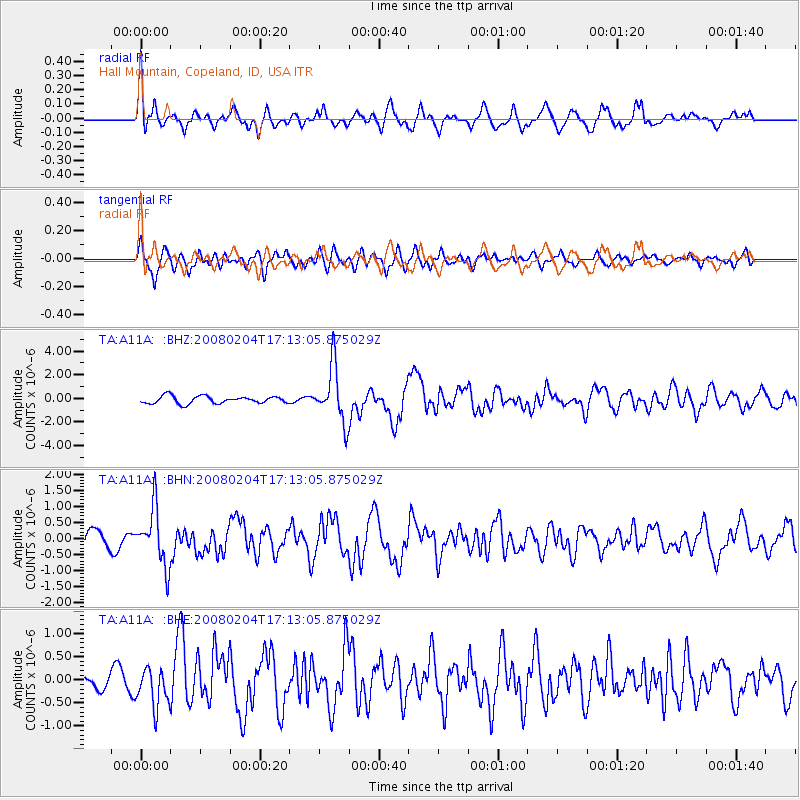
A11A Hall Mountain, Copeland, ID, USA - Earthquake Result Viewer
| Earthquake location: |
Near Coast Of Northern Chile |
| Earthquake latitude/longitude: |
-20.2/-70.0 |
| Earthquake time(UTC): |
2008/02/04 (035) 17:01:30 GMT |
| Earthquake Depth: |
44 km |
| Earthquake Magnitude: |
6.0 MB, 6.2 MS, 6.3 MW, 6.3 MW |
| Earthquake Catalog/Contributor: |
WHDF/NEIC |
|
| Network: |
TA USArray Transportable Network (new EarthScope stations) |
| Station: |
A11A Hall Mountain, Copeland, ID, USA |
| Lat/Lon: |
48.96 N/116.36 W |
| Elevation: |
1455 m |
|
| Distance: |
80.2 deg |
| Az: |
331.069 deg |
| Baz: |
136.409 deg |
| Ray Param: |
0.048354227 |
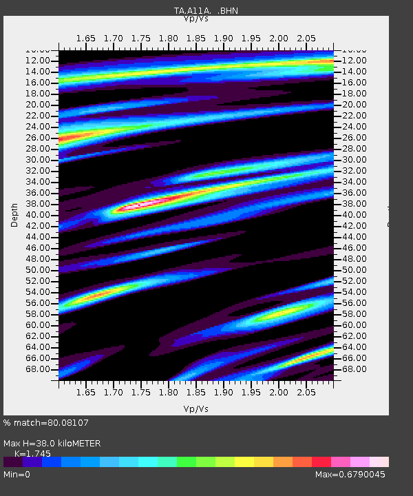
| Estimated Moho Depth: |
38.0 km |
| Estimated Crust Vp/Vs: |
1.75 |
| Assumed Crust Vp: |
6.571 km/s |
| Estimated Crust Vs: |
3.765 km/s |
| Estimated Crust Poisson's Ratio: |
0.26 |
|
| Radial Match: |
80.08107 % |
| Radial Bump: |
400 |
| Transverse Match: |
76.88952 % |
| Transverse Bump: |
400 |
| SOD ConfigId: |
2564 |
| Insert Time: |
2010-03-07 04:29:13.511 +0000 |
| GWidth: |
2.5 |
| Max Bumps: |
400 |
| Tol: |
0.001 |
|
Signal To Noise
| Channel | StoN | STA | LTA |
| TA:A11A: :BHN:20080204T17:13:05.875029Z | 4.3928638 | 8.8015065E-7 | 2.003592E-7 |
| TA:A11A: :BHE:20080204T17:13:05.875029Z | 1.3567835 | 4.193215E-7 | 3.090556E-7 |
| TA:A11A: :BHZ:20080204T17:13:05.875029Z | 7.520295 | 2.3504815E-6 | 3.1255175E-7 |
| Arrivals |
| Ps | 4.4 SECOND |
| PpPs | 15 SECOND |
| PsPs/PpSs | 20 SECOND |


