
Station TA A11A - Hall Mountain, Copeland, ID, USA
Network: TA - USArray Transportable Network (new EarthScope stations)
Nearby stations (2 deg radius)
| Station | Name | (Lat, Lon) | Start / End | Elevation |
| A11A | Hall Mountain, Copeland, ID, USA | (48.96, -116.36) | 2006-10-10 / 2499-01-01 | 1.5 km |
| Crust2 Type: | Q9,orogen/41km no ice, cordilleras, 0.25 km seds. |
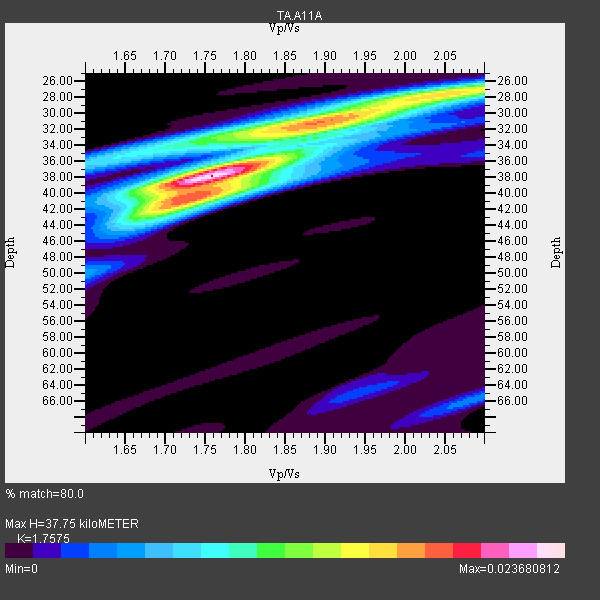
| Thickness Estimate: | 38 km |
| Thickness StdDev: | 2.7 km |
| Vp/Vs Estimate: | 1.76 |
| Vp/Vs StdDev: | 0.04 |
| Vs Estimate: | 3.739 km/s |
| Poisson's Ratio: | 0.26 |
| Peak Value: | 0.02 |
| Assumed Vp: | 6.571 km/s |
| Ps Weight: | 0.33333334 |
| PpPs Weight: | 0.33333334 |
| PsPs Weight: | 0.33333328 |
| Residual Complexity: | 0.693 |
| Nearby stations H: | +- |
| (2.0 deg) Vp/Vs: | +- |
23 with match > 90% ( 58.974358 %) and 39 with match > 80% ( 100.0 %) out of 39.
Download stack as xyz text file.
Azimuth Distribution of Events:

Prior Results for this Station
| Study | Thickness | Vp/Vs | Vp | Vs | Poissons Ratio | Extra |
| EARS | 38 km | 1.76 | 6.571 km/s | 3.739 km/s | 0.26 | |
| Crust2.0 | 41 km | 1.76 | 6.571 km/s | 3.735 km/s | 0.26 | Q9,orogen/41km no ice, cordilleras, 0.25 km seds. |
| Global Maxima | 38 km | 1.76 | 6.571 km/s | 3.739 km/s | 0.26 | amp=0.023680812 |
| Local Maxima 1 | 30 km | 1.92 | 6.571 km/s | 3.422 km/s | 0.31 | amp=0.016566155 |
| Local Maxima 2 | 40 km | 1.74 | 6.571 km/s | 3.782 km/s | 0.25 | amp=0.013527136 |
| Local Maxima 3 | 28 km | 2.05 | 6.571 km/s | 3.205 km/s | 0.34 | amp=0.012956917 |
| Local Maxima 4 | 35 km | 1.67 | 6.571 km/s | 3.929 km/s | 0.22 | amp=0.007867921 |
| Predicted Arrivals for vertical incidence (zero ray parameter) | |
| Ps | 4.35 SECOND |
| PpPs | 15.84 SECOND |
| PsPs/PpSs | 20.19 SECOND |
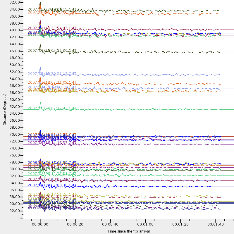
Events Processed for this Station
Download zip of receiver functions as SAC
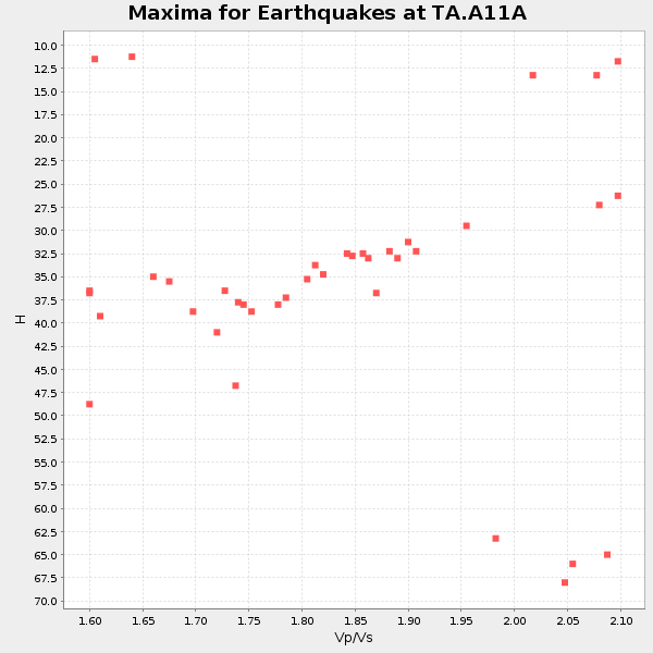
Plot maxima for each earthquake.
Events Used in the Stack
(39 events)| Radial Match | Distance | Baz | FERegion | Time | Lat/Lon | Depth | Magnitude |
| 98.67002 | 57.2 deg | 304.877 deg | Kuril Islands | 2006/11/15 11:14:13 GMT | (46.6, 153.3) | 10 km | 6.5 MB, 7.8 MS, 8.3 MW, 7.9 MW |
| 98.41383 | 90.8 deg | 253.346 deg | Santa Cruz Islands | 2007/09/02 01:05:18 GMT | (-11.6, 165.8) | 35 km | 5.9 MB, 7.3 MS, 7.2 MW, 6.9 ME |
| 97.43005 | 92.7 deg | 249.37 deg | Vanuatu Islands | 2007/08/01 17:08:51 GMT | (-15.6, 167.7) | 120 km | 6.2 MB, 7.2 MW, 7.2 MW |
| 97.10482 | 92.4 deg | 232.089 deg | South Of Fiji Islands | 2007/12/09 07:28:20 GMT | (-26.0, -177.5) | 152 km | 7.0 MB, 7.8 MW, 7.7 MW |
| 97.00944 | 94.1 deg | 261.9 deg | Solomon Islands | 2007/04/01 20:39:56 GMT | (-8.5, 157.0) | 10 km | 6.8 MB, 7.9 MS, 8.1 MW, 7.7 ME |
| 96.89199 | 71.3 deg | 138.929 deg | Near Coast Of Peru | 2007/08/15 23:40:57 GMT | (-13.4, -76.6) | 39 km | 6.7 MB, 7.9 MS, 8.0 MW, 7.5 ME |
| 96.099365 | 71.4 deg | 305.958 deg | Near West Coast Of Honshu, Japan | 2007/07/16 01:13:22 GMT | (37.5, 138.4) | 12 km | 6.5 MB, 6.4 MS, 6.6 MW, 6.5 MW |
| 95.8098 | 80.6 deg | 292.563 deg | Volcano Islands, Japan Region | 2007/09/28 13:38:59 GMT | (22.0, 142.7) | 276 km | 6.7 MB, 7.4 MW, 7.4 MW |
| 95.515 | 82.1 deg | 137.3 deg | Northern Chile | 2007/11/14 15:40:50 GMT | (-22.2, -69.9) | 40 km | 6.7 MB, 7.4 MS, 7.7 MW, 7.4 ME |
| 94.85319 | 87.3 deg | 282.766 deg | South Of Mariana Islands | 2007/09/30 02:08:30 GMT | (10.5, 145.7) | 14 km | 6.4 MB, 7.1 MS, 6.9 MW, 6.9 MW |
| 94.65016 | 54.7 deg | 131.407 deg | South Of Panama | 2007/03/18 02:11:05 GMT | (4.6, -78.5) | 8.0 km | 6.4 MB, 5.7 MS, 6.2 MW, 6.1 MW |
| 94.363625 | 90.3 deg | 308.883 deg | Taiwan Region | 2007/09/06 17:51:26 GMT | (24.3, 122.2) | 53 km | 6.1 MB, 6.2 MW, 6.1 ME |
| 94.18216 | 37.4 deg | 297.797 deg | Andreanof Islands, Aleutian Is. | 2007/07/13 21:54:43 GMT | (51.8, -176.3) | 35 km | 5.7 MB, 5.6 MS, 6.0 MW, 5.9 MW |
| 94.12022 | 38.7 deg | 295.968 deg | Andreanof Islands, Aleutian Is. | 2007/08/15 20:22:11 GMT | (50.3, -177.5) | 9.0 km | 6.3 MB, 6.2 MS, 6.4 MW, 5.9 ML |
| 93.77099 | 81.2 deg | 288.563 deg | Mariana Islands | 2007/10/31 03:30:17 GMT | (18.9, 145.4) | 223 km | 6.2 MB, 7.2 MW, 7.2 MW |
| 93.43448 | 32.3 deg | 296.214 deg | Fox Islands, Aleutian Islands | 2007/07/15 13:08:00 GMT | (52.5, -168.0) | 10 km | 5.8 MB, 5.9 MS, 6.1 MW, 6.0 MW |
| 93.29264 | 56.1 deg | 107.283 deg | Windward Islands | 2007/11/29 19:00:19 GMT | (15.0, -61.3) | 148 km | 6.9 MB, 7.4 MW, 7.4 MW |
| 93.02615 | 56.9 deg | 303.894 deg | East Of Kuril Islands | 2006/12/07 19:10:21 GMT | (46.2, 154.4) | 16 km | 6.3 MB, 6.1 MS, 6.3 MW, 6.3 MW |
| 92.841934 | 92.0 deg | 248.824 deg | Vanuatu Islands | 2007/07/15 09:27:34 GMT | (-15.4, 168.6) | 8.0 km | 6.0 MB, 5.8 MS, 6.1 MW, 6.0 MW |
| 92.15921 | 51.8 deg | 308.513 deg | Kamchatka Peninsula, Russia | 2007/05/30 20:22:12 GMT | (52.1, 157.3) | 116 km | 6.4 MB, 6.4 MW, 6.4 MW |
| 91.86173 | 72.5 deg | 306.979 deg | Near West Coast Of Honshu, Japan | 2007/03/25 00:41:57 GMT | (37.3, 136.6) | 8.0 km | 6.1 MB, 6.8 MS, 6.7 MW, 6.6 MW |
| 90.88309 | 39.4 deg | 298.253 deg | Andreanof Islands, Aleutian Is. | 2007/12/19 09:30:27 GMT | (51.4, -179.5) | 29 km | 6.4 MB, 7.1 MS, 7.1 MW, 7.0 MW |
| 90.78149 | 62.8 deg | 311.28 deg | Sakhalin, Russia | 2007/08/02 02:37:42 GMT | (47.1, 141.8) | 5.0 km | 6.2 MS, 5.3 MB, 6.2 MW, 6.2 MW |
| 89.48714 | 73.8 deg | 307.715 deg | Sea Of Japan | 2007/07/16 14:17:37 GMT | (36.8, 134.9) | 350 km | 6.2 MB, 6.8 MW, 6.8 MW |
| 88.012245 | 85.4 deg | 307.161 deg | Northwest Of Ryukyu Islands | 2007/07/31 15:07:35 GMT | (27.3, 126.9) | 10 km | 5.5 MB, 5.7 MS, 5.9 MW, 5.9 MW |
| 87.75466 | 93.5 deg | 259.197 deg | Solomon Islands | 2007/08/16 08:39:27 GMT | (-9.8, 159.5) | 10 km | 6.1 MB, 6.7 MS, 6.4 MW |
| 87.65657 | 44.5 deg | 305.334 deg | Komandorskiye Ostrova Region | 2007/07/29 04:54:36 GMT | (53.6, 169.7) | 26 km | 6.0 MB, 5.5 MS, 5.9 MW, 5.8 MW |
| 86.060234 | 38.7 deg | 295.859 deg | Andreanof Islands, Aleutian Is. | 2007/08/16 04:03:03 GMT | (50.2, -177.6) | 15 km | 5.8 MB |
| 84.94087 | 71.5 deg | 139.029 deg | Near Coast Of Peru | 2007/08/17 13:18:13 GMT | (-13.6, -76.6) | 48 km | 5.6 MB, 5.6 MS, 5.9 MW |
| 84.36639 | 31.3 deg | 142.361 deg | Gulf Of Mexico | 2007/05/23 19:09:15 GMT | (21.9, -96.4) | 10 km | 5.6 MW, 4.8 MS, 5.4 MB |
| 84.15441 | 80.1 deg | 290.432 deg | Mariana Islands | 2007/01/30 21:37:45 GMT | (21.0, 144.7) | 30 km | 6.3 MB, 6.5 MS, 6.6 MW, 6.5 MW |
| 83.996155 | 94.4 deg | 269.68 deg | New Ireland Region, P.N.G. | 2007/06/18 06:18:48 GMT | (-3.6, 151.0) | 26 km | 5.7 MB, 6.2 MS, 6.3 MW, 6.1 MW |
| 83.52314 | 82.0 deg | 233.727 deg | Samoa Islands Region | 2007/07/06 17:40:49 GMT | (-16.4, -172.6) | 10 km | 5.5 MB, 5.1 MS, 5.7 MW |
| 83.20035 | 83.7 deg | 234.5 deg | Tonga Islands | 2007/08/26 12:37:31 GMT | (-17.5, -174.3) | 127 km | 5.9 MB, 6.1 MW |
| 82.960976 | 71.5 deg | 139.054 deg | Near Coast Of Peru | 2007/08/19 01:22:40 GMT | (-13.6, -76.6) | 26 km | 5.9 MB, 5.4 MS, 5.8 MW, 5.5 ML |
| 81.790535 | 72.3 deg | 138.912 deg | Near Coast Of Peru | 2007/08/16 05:16:56 GMT | (-14.3, -76.1) | 23 km | 5.8 MB, 6.1 MS, 6.3 MW, 6.2 ML |
| 80.91423 | 85.5 deg | 307.175 deg | Northwest Of Ryukyu Islands | 2007/08/07 00:02:24 GMT | (27.3, 126.8) | 18 km | 5.5 MB, 5.8 MS, 5.9 MW, 5.9 MW |
| 80.53338 | 39.1 deg | 298.044 deg | Andreanof Islands, Aleutian Is. | 2007/12/21 07:24:34 GMT | (51.4, -179.0) | 30 km | 6.1 MB, 6.2 MW, 6.3 ML |
| 80.08107 | 80.2 deg | 136.409 deg | Near Coast Of Northern Chile | 2008/02/04 17:01:30 GMT | (-20.2, -70.0) | 44 km | 6.0 MB, 6.2 MS, 6.3 MW, 6.3 MW |
Losers
(0 events)| Radial Match | Distance | Baz | FERegion | Time | Lat/Lon | Depth | Magnitude | Reason |
