You are here: Home > Network List > TA - USArray Transportable Network (new EarthScope stations) Stations List
> Station A11A Hall Mountain, Copeland, ID, USA > Earthquake Result Viewer
A11A Hall Mountain, Copeland, ID, USA - Earthquake Result Viewer
| Earthquake location: |
South Of Fiji Islands |
| Earthquake latitude/longitude: |
-26.0/-177.5 |
| Earthquake time(UTC): |
2007/12/09 (343) 07:28:20 GMT |
| Earthquake Depth: |
152 km |
| Earthquake Magnitude: |
7.0 MB, 7.8 MW, 7.7 MW |
| Earthquake Catalog/Contributor: |
WHDF/NEIC |
|
| Network: |
TA USArray Transportable Network (new EarthScope stations) |
| Station: |
A11A Hall Mountain, Copeland, ID, USA |
| Lat/Lon: |
48.96 N/116.36 W |
| Elevation: |
1455 m |
|
| Distance: |
92.4 deg |
| Az: |
35.297 deg |
| Baz: |
232.089 deg |
| Ray Param: |
0.041380648 |
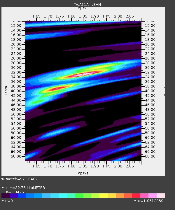
| Estimated Moho Depth: |
32.75 km |
| Estimated Crust Vp/Vs: |
1.85 |
| Assumed Crust Vp: |
6.571 km/s |
| Estimated Crust Vs: |
3.557 km/s |
| Estimated Crust Poisson's Ratio: |
0.29 |
|
| Radial Match: |
97.10482 % |
| Radial Bump: |
400 |
| Transverse Match: |
88.63173 % |
| Transverse Bump: |
400 |
| SOD ConfigId: |
2564 |
| Insert Time: |
2010-03-07 04:29:21.857 +0000 |
| GWidth: |
2.5 |
| Max Bumps: |
400 |
| Tol: |
0.001 |
|
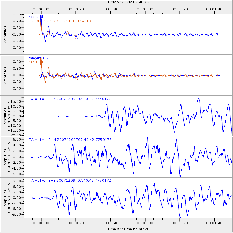
Signal To Noise
| Channel | StoN | STA | LTA |
| TA:A11A: :BHN:20071209T07:40:42.775017Z | 1.809285 | 2.6074133E-7 | 1.441129E-7 |
| TA:A11A: :BHE:20071209T07:40:42.775017Z | 1.892993 | 3.3917055E-7 | 1.791716E-7 |
| TA:A11A: :BHZ:20071209T07:40:42.775017Z | 5.464657 | 7.8193057E-7 | 1.430887E-7 |
| Arrivals |
| Ps | 4.3 SECOND |
| PpPs | 14 SECOND |
| PsPs/PpSs | 18 SECOND |


