You are here: Home > Network List > TA - USArray Transportable Network (new EarthScope stations) Stations List
> Station A11A Hall Mountain, Copeland, ID, USA > Earthquake Result Viewer
A11A Hall Mountain, Copeland, ID, USA - Earthquake Result Viewer
| Earthquake location: |
Santa Cruz Islands |
| Earthquake latitude/longitude: |
-11.6/165.8 |
| Earthquake time(UTC): |
2007/09/02 (245) 01:05:18 GMT |
| Earthquake Depth: |
35 km |
| Earthquake Magnitude: |
5.9 MB, 7.3 MS, 7.2 MW, 6.9 ME |
| Earthquake Catalog/Contributor: |
WHDF/NEIC |
|
| Network: |
TA USArray Transportable Network (new EarthScope stations) |
| Station: |
A11A Hall Mountain, Copeland, ID, USA |
| Lat/Lon: |
48.96 N/116.36 W |
| Elevation: |
1455 m |
|
| Distance: |
90.8 deg |
| Az: |
40.127 deg |
| Baz: |
253.346 deg |
| Ray Param: |
0.041640103 |
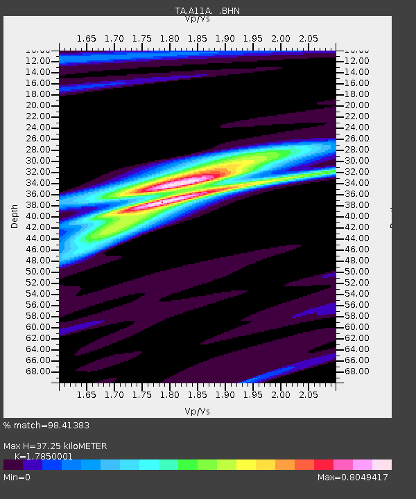
| Estimated Moho Depth: |
37.25 km |
| Estimated Crust Vp/Vs: |
1.79 |
| Assumed Crust Vp: |
6.571 km/s |
| Estimated Crust Vs: |
3.681 km/s |
| Estimated Crust Poisson's Ratio: |
0.27 |
|
| Radial Match: |
98.41383 % |
| Radial Bump: |
276 |
| Transverse Match: |
85.82487 % |
| Transverse Bump: |
400 |
| SOD ConfigId: |
2564 |
| Insert Time: |
2010-03-07 04:29:34.719 +0000 |
| GWidth: |
2.5 |
| Max Bumps: |
400 |
| Tol: |
0.001 |
|

Signal To Noise
| Channel | StoN | STA | LTA |
| TA:A11A: :BHN:20070902T01:17:46.699011Z | 3.9108462 | 2.2617311E-7 | 5.783227E-8 |
| TA:A11A: :BHE:20070902T01:17:46.699011Z | 14.521701 | 7.870389E-7 | 5.4197432E-8 |
| TA:A11A: :BHZ:20070902T01:17:46.699011Z | 31.402317 | 2.0314499E-6 | 6.469108E-8 |
| Arrivals |
| Ps | 4.5 SECOND |
| PpPs | 15 SECOND |
| PsPs/PpSs | 20 SECOND |


